
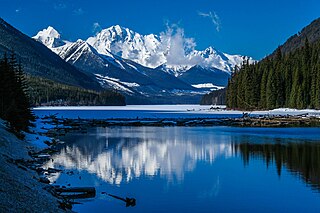
Mount Robson Provincial Park is a provincial park in the Canadian Rockies with an area of 2,249 km2. The park is located entirely within British Columbia, bordering Jasper National Park in Alberta. The B.C. legislature created the park in 1913, the same year as the first ascent of Mount Robson by a party led by Conrad Kain. It is the second oldest park in the provincial system. The park is named for Mount Robson, which has the highest point in the Canadian Rockies and is located entirely within the park.

Kokanee Glacier Provincial Park is one of the oldest provincial parks in British Columbia, established in 1922. The park has an area of 320.35 km2 (123.69 sq mi) and is located in the Selkirk Mountains in the West Kootenays region of BC. The park has three glaciers that feed over 30 alpine lakes which are the headwaters of many creeks.
Beaver Creek Provincial Park is a Class C provincial park in the Regional District of Kootenay Boundary in British Columbia, Canada.
Duffey Lake Provincial Park is a provincial park in British Columbia, Canada, located at the lake of the same name, which lies along BC Highway 99 just east of the summit of Cayoosh Pass. The lake's inflow and outflow are Cayoosh Creek. The park's highest point is Mount Rohr at the westernmost boundary.

Davis Lake Provincial Park is a 185 acres (0.75 km2) park in British Columbia, Canada, established as a protected provincial park in October 1963. It is located east of the southern end of Stave Lake, northeast of Mission, British Columbia, approximately 18 km north on Sylvester Rd from BC Highway 7. There are campgrounds and beaches at the south end of the lake, access is walk-in only via a 1 km unmaintained gravel road.
Emory Creek Provincial Park is a provincial park in British Columbia, Canada, located on the west side of the Fraser River just south of the town of Yale. It commemorates the location of a large boomtown, variously known as Emory, Emory Bar or Emory City, that first rose during the Fraser Canyon Gold Rush but became a major construction town during the building of the Canadian Pacific Railway in the 1880s.
Emory Creek in 1858 was a tent and shack camp, established by miners in search of gold. When it became evident that the gold was not available in the amounts estimated, the miners started moving north on the Fraser River. A few Chinese remained in the area. The area came into the hands of a man named Walker, who felt Emory Creek would become the head of riverboat navigation on the Fraser. Eventually, he sold the land to the Oppenheimer Brothers in early 1879. In the fall of 1879, Emory was chosen by the C.P.R. as the western terminus. In a short time it became Emory Creek. The town consisted of thirteen streets with its own newspaper, various shops, a brewery, nine saloons and a sawmill. When Yale was made the terminus, Emory was all but abandoned by 1885, with the completion of the railway. Today, it is an easily accessible treed campground with paved roads and flush outhouses.

Juan de Fuca Provincial Park is a provincial park located on the west coast of Vancouver Island in British Columbia, Canada. The park was established on April 4, 1996 by combining three former parks — China Beach, Loss Creek, and Botanical Beach — into one provincial park. It is the location of the majority of the Juan de Fuca Marine Trail, which is a southern compliment to the West Coast Trail within Pacific Rim National Park Reserve.

Kakwa Provincial Park and Protected Area is a 170,890 ha provincial park in northeastern British Columbia, Canada. The park preserves the southernmost portion of the Hart Ranges and the northernmost portion of the Continental Ranges. The park also preserves significant marine fossil deposits located in the region.
Kikomun Creek Provincial Park is a provincial park in British Columbia, Canada.
Mehatl Creek Provincial Park is a provincial park in British Columbia, Canada, located in the central Lillooet Ranges to the west of Boston Bar.
Nitinat River Provincial Park is a provincial park in the Canadian province of British Columbia on Vancouver Island.
Weymer Creek Provincial Park, formerly Weymer Creek Karst Provincial Park, is a provincial park located on the west coast of Vancouver Island in British Columbia, Canada, just southeast of the community of Tahsis in the region of Nootka Sound. Its most important feature is its karst topography and some of the deepest caves in Canada. Caving is currently not permitted in the park and visitors to the area are requested to practice "no trace" camping.

The Purcell Wilderness Conservancy is a provincial park in British Columbia, Canada. It was established in 1974, and encompasses six large drainages in the Purcell Mountains in the southeast of the province. It contains high peaks, alpine meadows and ridges, deep creek and river valleys, and hot springs at Dewar Creek.

Rearguard Falls Provincial Park is a provincial park in British Columbia, Canada, protecting Rearguard Falls on the Fraser River. It is located just above its emergence into the Rocky Mountain Trench near the community of Tete Jaune Cache. The park is easily accessed via BC Highway 16. Rearguard Falls is one of only two waterfalls on the 1,375 km (854 mi)-long Fraser River; the other is a few kilometres upstream at Overlander Falls. Rearguard Falls offers a view of the return of Chinook salmon for spawning.

Rosewall Creek Provincial Park is a provincial park in British Columbia, Canada, located northwest of the community of Bowser. The park is situated along picturesque Rosewall Creek, south of Fanny Bay on central Vancouver Island. The park features a mixture of coniferous trees interspersed with striking broad leaf maple trees. One of the best times to visit this park is in the fall when the color of the maple leaves makes an attractive backdrop for photographers.
Tranquil Creek Provincial Park is a provincial park in British Columbia, Canada, located at the head of the Kennedy River, east of the head of Bedwell Sound on Vancouver Island.

The Churn Creek Protected Area is a 36,747-hectare (90,800-acre) provincial protected area in British Columbia, Canada. It is a mix of dryland canyon and steppe and adjoining rangeland flanking the canyon of Churn Creek and that stream's confluence with the Fraser River at the northern apex of the Camelsfoot Range. The historic Gang Ranch is just north of the Churn Creek Protected Area. The Empire Valley Ranch ecological preserve was added to the Protected Area in an expansion.
The Nahatlatch River is a tributary of the Fraser River in the Canadian province of British Columbia. It originates in the Lillooet Ranges of the Coast Mountains and empties into the Fraser River in the Fraser Canyon, north of Boston Bar.
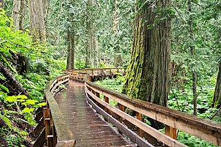
Ancient Forest/Chun T'oh Whudujut Provincial Park and Protected Area is a provincial park and protected area located in the regional district of Fraser-Fort George in the Canadian province of British Columbia. The park was established on 19 May 2016 to protect a portion of the North American inland temperate rainforest, the only inland temperate rainforest in the world.


