
Mount Robson Provincial Park is a provincial park in the Canadian Rockies with an area of 2,249 km2. The park is located entirely within British Columbia, bordering Jasper National Park in Alberta. The B.C. legislature created the park in 1913, the same year as the first ascent of Mount Robson by a party led by Conrad Kain. It is the second oldest park in the provincial system. The park is named for Mount Robson, which has the highest point in the Canadian Rockies and is located entirely within the park.

Garibaldi Provincial Park, also called Garibaldi Park, is a wilderness park located on the coastal mainland of British Columbia, Canada, 70 kilometres (43.5 mi) north of Vancouver. It was established in 1920 and named a Class A Provincial Park of British Columbia in 1927. The park is a popular destination for outdoor recreation, with over 30,000 overnight campers and over 106,000 day users in the 2017/2018 season.
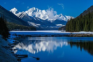
Duffey Lake Provincial Park is a provincial park in British Columbia, Canada, located at the lake of the same name, which lies along BC Highway 99 just east of the summit of Cayoosh Pass. The lake's inflow and outflow are Cayoosh Creek. The park's highest point is Mount Rohr at the westernmost boundary.
Hai Lake–Mount Herman Provincial Park is a provincial park in British Columbia, Canada. Established in 2004, it is 323 ha. and protects regionally significant bog ecosystems and old-growth forests. The park caters to outdoor pursuits such as day hiking, camping, fishing, and hunting.

Juniper Beach Provincial Park is a provincial park in the Thompson Country region of south central British Columbia, Canada. The facility is on the north side of the Thompson River, west of the town of Savona, and downstream from the Kamloops Lake outflow. On BC Highway 1, the locality is by road about 20 kilometres (12 mi) east of Cache Creek and 65 kilometres (40 mi) west of Kamloops.

Little Qualicum Falls Provincial Park is a provincial park in British Columbia, Canada, on central Vancouver Island, that encompasses the entire southern shore of Cameron Lake. The Island Rail Corridor line to Port Alberni passes through the park.
Mount Blanchet Provincial Park is a provincial park in British Columbia, Canada, located on the west side of the southern end of Takla Lake, north of Smithers.

Mount Elphinstone Provincial Park is a provincial park located near BC Highway 101, in British Columbia, Canada. Located near Mount Elphinstone, the park is on the west side of Howe Sound and north of the town of Gibsons and near the community of Roberts Creek. Created in 2000, the park is approximately 141 hectares in size.
Mount Fernie Provincial Park is a provincial park located just west of the town of Fernie in British Columbia, Canada. It was established on May 4, 1959 to protect the ecology of the lower Lizard River while providing recreational opportunities for local residents and visitors alike. The park is named after Mount Fernie, a prominent peak located north of the park.
Mount Geoffrey Escarpment Provincial Park is a Class-A provincial park in British Columbia, Canada, located on the southwest coast of Hornby Island. It covers an area of 187 hectares, stretching from the Shingle Spit ferry landing in the west to Ford Cove in the east.

Mount Maxwell Provincial Park is a provincial park in the Gulf Islands of British Columbia, Canada. It is located on Burgoyne Bay and the Sansum Narrows on the western shores of Saltspring Island.
Mount Richardson Provincial Park is a provincial park in British Columbia, Canada, located on the lower Sunshine Coast to the north of Sechelt.
Mount Terry Fox Provincial Park is a provincial park in British Columbia, Canada. It is located in the Rocky Mountains near Mount Robson and the city of Valemount, British Columbia. The park and Mount Terry Fox, which is within the park, are named in honor of amputee long-distance runner and cancer research activist Terry Fox, a native of Winnipeg, Manitoba who grew up in British Columbia.

The Purcell Wilderness Conservancy is a provincial park in British Columbia, Canada. It was established in 1974, and encompasses six large drainages in the Purcell Mountains in the southeast of the province. It contains high peaks, alpine meadows and ridges, deep creek and river valleys, and hot springs at Dewar Creek.
Steelhead Provincial Park is a provincial park in the Thompson Country region of south central British Columbia, Canada. The facility is at the west end of Kamloops Lake near the town of Savona. On BC Highway 1, the locality is by road about 38 kilometres (24 mi) east of Cache Creek and 45 kilometres (28 mi) west of Kamloops.
Tunkwa Provincial Park is a provincial park on the northern Thompson Plateau in south central British Columbia, Canada. The locality is by road about 16 kilometres (10 mi) north of Logan Lake and 27 kilometres (17 mi) south of Savona.

Mount Seymour Provincial Park is a park in Vancouver, British Columbia's North Shore Mountains. With an area of 35 square kilometres, it is located approximately 15 kilometres north of Downtown Vancouver. The park, named after Frederick Seymour, was established in 1936. Mount Seymour Provincial Park provides visitors with a variety of recreational activities and animals with natural habitat.

Mount Arrowsmith Biosphere Region (MABR) is a UNESCO Biosphere Reserve located on the east coast of Vancouver Island in British Columbia, Canada. It was designated in 2000 by UNESCO to protect a large second-growth coast Douglas fir ecosystem in the watersheds of the Little Qualicum and Englishman Rivers from being developed.

The Sea to Sea Green Blue Belt is a 62 kilometre long greenbelt surrounding the Greater Victoria metropolitan area in Canada. The greenbelt includes green space, forests, farms, and wetlands stretching from Sooke to Salt Spring Island. It also includes the "blue spaces" of Sooke Basin and Saanich Inlet.

