List of provincial parks of British Columbia Northern Interior

Last updated

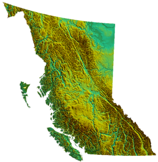
The list of provincial parks of the British Columbia Northern Interior contains the provincial parks located within this geographic region of the province of British Columbia. It includes parks from the three regional districts of Northern Rockies, Peace River and Stikine. These parks are administered by BC Parks under the jurisdiction of the Ministry of Environment and Climate Change Strategy.

List of parks

Park nameClassificationRegional districtsCoordinatesSizeEstablishedRemarks
haacres
Andy Bailey Provincial Park Provincial Park Northern Rockies
58°33′N122°30′W / 58.55°N 122.50°W / 58.55; -122.50 (Andy Bailey Provincial Park)
58°33′N122°30′W / 58.55°N 122.50°W / 58.55; -122.50
Atlin Provincial Park and Recreation Area Provincial Park Stikine Region 59°31′21″N133°45′36″W / 59.5225°N 133.76°W / 59.5225; -133.76
Bearhole Lake Provincial Park Provincial Park Peace River 55°02′50″N120°33′00″W / 55.0472°N 120.55°W / 55.0472; -120.55
Beatton Provincial Park Provincial Park Peace River 56°20′00″N120°55′59″W / 56.3333°N 120.933°W / 56.3333; -120.933
Beatton River Provincial Park Provincial Park Peace River 56°06′00″N120°22′30″W / 56.10°N 120.375°W / 56.10; -120.375
Bocock Peak Provincial Park Provincial Park Peace River 55°51′00″N122°55′59″W / 55.85°N 122.933°W / 55.85; -122.933
Boya Lake Provincial Park Provincial Park Stikine Region 59°23′00″N129°04′59″W / 59.3833°N 129.083°W / 59.3833; -129.083
Buckinghorse River Wayside Provincial Park Provincial Park Peace River 57°23′00″N122°49′59″W / 57.3833°N 122.833°W / 57.3833; -122.833
Butler Ridge Provincial Park Provincial Park Peace River 56°11′00″N122°18′00″W / 56.1833°N 122.30°W / 56.1833; -122.30
Charlie Lake Provincial Park Provincial Park Peace River 56°18′30″N120°59′46″W / 56.3083°N 120.996°W / 56.3083; -120.996
Chase Provincial Park Provincial Park Peace River 56°30′30″N125°01′44″W / 56.5083°N 125.029°W / 56.5083; -125.029
Dall River Old Growth Provincial Park Provincial Park Stikine Region 58°39′N127°42′W / 58.65°N 127.70°W / 58.65; -127.70
Denetiah Provincial Park Provincial Park Stikine Region 58°30′00″N127°25′01″W / 58.5°N 127.417°W / 58.5; -127.417
Dune Za Keyih Provincial Park and Protected Area Provincial Park
Protected Area
Stikine Region 58°25′00″N126°19′59″W / 58.4167°N 126.333°W / 58.4167; -126.333
East Pine Provincial Park Provincial Park Peace River 55°43′00″N121°13′01″W / 55.7167°N 121.217°W / 55.7167; -121.217
Ed Bird – Estella Lakes Provincial Park Provincial Park Peace River 56°56′02″N125°05′49″W / 56.934°N 125.097°W / 56.934; -125.097
Finlay-Russel Provincial Park and Protected Area Provincial Park
Protected Area
Peace River 57°32′00″N126°10′01″W / 57.5333°N 126.167°W / 57.5333; -126.167
Graham-Laurier Provincial Park Provincial Park Peace River 56°38′00″N123°30′00″W / 56.6333°N 123.50°W / 56.6333; -123.50
Gwillim Lake Provincial Park Provincial Park Peace River 55°25′59″N121°13′59″W / 55.433°N 121.233°W / 55.433; -121.233
Hole-in-the-Wall Provincial Park Provincial Park Peace River 55°08′46″N121°51′14″W / 55.146°N 121.854°W / 55.146; -121.854
Horneline Creek Provincial Park Provincial Park Stikine Region 59°00′N127°15′W / 59.0°N 127.25°W / 59.0; -127.25
Hyland River Provincial Park Provincial Park Stikine Region 59°57′39″N128°09′08″W / 59.9609°N 128.1522°W / 59.9609; -128.1522
Jackpine Remnant Provincial Park Provincial Park Northern Rockies 59°10′N123°17′W / 59.17°N 123.28°W / 59.17; -123.28
Kiskatinaw Provincial Park Provincial Park Peace River 55°58′N120°34′W / 55.96°N 120.56°W / 55.96; -120.56
Kotcho Lake Village Provincial Park Provincial Park Northern Rockies 59°01′21″N121°05′02″W / 59.0226°N 121.084°W / 59.0226; -121.084
Kwadacha Wilderness Provincial Park Provincial Park Peace River 57°48′00″N125°07′01″W / 57.8°N 125.117°W / 57.8; -125.117
Liard River Corridor Provincial Park Provincial Park Northern Rockies 59°18′00″N125°22′59″W / 59.30°N 125.383°W / 59.30; -125.383
Liard River Hot Springs Provincial Park Provincial Park Northern Rockies 59°24′00″N126°04′01″W / 59.40°N 126.067°W / 59.40; -126.067
Maxhamish Lake Provincial Park and Protected Area Provincial Park
Protected Area
Northern Rockies 59°49′34″N123°16′34″W / 59.8262°N 123.276°W / 59.8262; -123.276
Milligan Hills Provincial Park Provincial Park Peace River 57°29′35″N120°13′50″W / 57.4931°N 120.2306°W / 57.4931; -120.2306
Moberly Lake Provincial Park Provincial Park Peace River 55°48′29″N121°41′38″W / 55.808°N 121.694°W / 55.808; -121.694
Monkman Provincial Park Provincial Park Peace River 54°36′00″N121°10′59″W / 54.6°N 121.183°W / 54.6; -121.183
Muncho Lake Provincial Park Provincial Park Northern Rockies 59°10′00″N126°01′01″W / 59.1667°N 126.017°W / 59.1667; -126.017
Muscovite Lakes Provincial Park Provincial Park Peace River 55°58′40″N124°08′45″W / 55.9778°N 124.1458°W / 55.9778; -124.1458
Northern Rocky Mountains Provincial Park Provincial Park Northern Rockies 58°11′29″N124°21′49″W / 58.1914°N 124.3636°W / 58.1914; -124.3636
One Island Lake Provincial Park Provincial Park Peace River 55°18′26″N120°17′35″W / 55.3071°N 120.293°W / 55.3071; -120.293
Peace River Corridor Provincial Park Provincial Park Peace River 56°06′10″N120°13′19″W / 56.1028°N 120.222°W / 56.1028; -120.222
Pine Le Moray Provincial Park Provincial Park Peace River 55°23′31″N122°31′08″W / 55.392°N 122.519°W / 55.392; -122.519
Pine River Breaks Provincial Park Provincial Park Peace River 55°41′00″N121°22′01″W / 55.6833°N 121.367°W / 55.6833; -121.367
Pink Mountain Provincial Park Provincial Park Peace River 57°02′40″N122°52′23″W / 57.0444°N 122.873°W / 57.0444; -122.873
Prophet River Hotsprings Provincial Park Provincial Park Peace River 57°39′05″N124°01′41″W / 57.6514°N 124.028°W / 57.6514; -124.028
Prophet River Wayside Provincial Park Provincial Park Peace River 57°58′00″N122°46′59″W / 57.9667°N 122.783°W / 57.9667; -122.783
Redfern-Keily Provincial Park Provincial Park Peace River 57°26′00″N123°57′00″W / 57.4333°N 123.95°W / 57.4333; -123.95
Scatter River Old Growth Provincial Park Provincial Park Northern Rockies 59°37′35″N124°39′00″W / 59.6264°N 124.65°W / 59.6264; -124.65
Sikanni Old Growth Provincial Park Provincial Park Northern Rockies 58°14′23″N121°42′57″W / 58.2397°N 121.7158°W / 58.2397; -121.7158
Smith River Falls – Fort Halkett Provincial Park Provincial Park Northern Rockies 59°33′30″N126°28′06″W / 59.5582°N 126.4684°W / 59.5582; -126.4684
Spatsizi Plateau Wilderness Provincial Park Provincial Park Stikine Region 57°25′00″N128°30′00″W / 57.4167°N 128.50°W / 57.4167; -128.50
Stikine River Provincial Park Provincial Park Stikine Region 57°55′59″N129°00′00″W / 57.933°N 129.0°W / 57.933; -129.0
Stone Mountain Provincial Park Provincial Park Northern Rockies 58°35′00″N124°45′00″W / 58.5833°N 124.75°W / 58.5833; -124.75
Sukunka Falls Provincial Park Provincial Park Peace River 55°19′45″N121°43′17″W / 55.3292°N 121.7214°W / 55.3292; -121.7214
Sustut Provincial Park Provincial Park Stikine Region 56°22′37″N126°41′55″W / 56.3769°N 126.6986°W / 56.3769; -126.6986
Swan Lake Provincial Park Provincial Park Peace River 55°31′37″N120°01′48″W / 55.527°N 120.03°W / 55.527; -120.03
Tatlatui Provincial Park Provincial Park Peace River 56°58′00″N127°22′59″W / 56.9667°N 127.383°W / 56.9667; -127.383
Tatshenshini-Alsek Provincial Park Provincial Park Stikine Region 59°27′22″N137°36′53″W / 59.4562°N 137.6147°W / 59.4562; -137.6147 (Tatshenshini-Alsek Provincial Park)
Taylor Landing Provincial Park Provincial Park Peace River 56°08′05″N120°39′58″W / 56.1347°N 120.6661°W / 56.1347; -120.6661
Tetsa River Provincial Park Provincial Park Northern Rockies 58°39′N123°57′W / 58.65°N 123.95°W / 58.65; -123.95
Toad River Hot Springs Provincial Park Provincial Park Northern Rockies 58°55′00″N125°04′01″W / 58.9167°N 125.067°W / 58.9167; -125.067
Tuya Mountains Provincial Park Provincial Park Stikine Region 59°10′19″N130°30′00″W / 59.172°N 130.50°W / 59.172; -130.50
Wapiti Lake Provincial Park Provincial Park Peace River 54°30′59″N120°46′30″W / 54.5164°N 120.7750°W / 54.5164; -120.7750
Map all coordinates using: OpenStreetMap  
Download coordinates as: KML

Commons-logo.svg Media related to Provincial Parks of British Columbia at Wikimedia Commons

Related Research Articles

British Columbia Province of Canada

British Columbia is the westernmost province of Canada. Situated between the Pacific Ocean and the continental divide of the Rocky Mountains, the province has a diverse geography, replete with rugged landscapes that include rocky coastlines, sandy beaches, forests, lakes, mountains, inland deserts and grassy plains. It borders the Canadian province of Alberta to the east and the Canadian territories of Yukon and the Northwest Territories to the north. With an estimated population of 5.2 million as of 2021, it is Canada's third-most populous province. The capital of British Columbia is Victoria and its largest city is Vancouver. Vancouver is the third-largest metropolitan area in Canada; the 2021 census recorded 2.6 million people in Metro Vancouver.

Shuswap Lake Lake in British Columbia, Canada

Shuswap Lake is a lake located in the southern interior of British Columbia, Canada that drains via the Little Shuswap River into Little Shuswap Lake. Little Shuswap Lake is the source of the South Thompson River, a branch of the Thompson River, a tributary of the Fraser River. It is at the heart of a region known as the Columbia Shuswap or "the Shuswap", noted for its recreational lakeshore communities including the city of Salmon Arm. The name "Shuswap" is derived from the Shuswap or Secwepemc First Nations people, the most northern of the Interior Salish peoples, whose territory includes the Shuswap. The Shuswap call themselves /ʃǝxwépmǝx/ in their own language, which is called /ʃǝxwepmǝxtʃín/, but the ethnonym's original meaning is now lost.

Williston Lake Body of water

Williston Lake is a reservoir created by the W. A. C. Bennett Dam and is located in the Northern Interior of British Columbia, Canada.

Columbia Mountains Mountain range in Canada and the United States

The Columbia Mountains are a group of mountain ranges along the upper Columbia River in British Columbia, Montana, Idaho and Washington. The mountain range covers 135,952 km². The range is bounded by the Rocky Mountain Trench on the east, and the Kootenai River on the south; their western boundary is the edge of the Interior Plateau. Seventy-five percent of the range is located in Canada and the remaining twenty-five percent in the United States; American geographic classifications place the Columbia Mountains as part of the Rocky Mountains complex, but this designation does not apply in Canada. Mount Sir Sandford is the highest mountain in the range, reaching 3,519 metres (11,545 ft).

Geography of British Columbia Overview of the geography of British Columbia

British Columbia is the westernmost province of Canada, bordered by the Pacific Ocean. With an area of 944,735 km2 (364,764 sq mi) it is Canada's third-largest province. The province is almost four times the size of the United Kingdom and larger than every United States state except Alaska and Texas. It is bounded on the northwest by the U.S. state of Alaska, directly north by Yukon and the Northwest Territories, on the east by Alberta, and on the south by the U.S. states of Washington, Idaho, and Montana. Formerly part of the British Empire, the southern border of British Columbia was established by the 1846 Oregon Treaty. The province is dominated by mountain ranges, among them the Canadian Rockies but dominantly the Coast Mountains, Cassiar Mountains, and the Columbia Mountains. Most of the population is concentrated on the Pacific coast, notably in the area of Vancouver, located on the southwestern tip of the mainland, which is known as the Lower Mainland. It is the most mountainous province of Canada.

Marble Canyon (British Columbia)

Marble Canyon is in the south-central Interior of British Columbia, a few kilometres east of the Fraser River and the community of Pavilion, midway between the towns of Lillooet and Cache Creek. The canyon stems from a collapsed karst formation.

Browne Lake Provincial Park

Browne Lake Provincial Park is a provincial park in British Columbia, Canada, located 22 km east-southeast of Kelowna in the Okanagan Highland, near Big White Ski Resort and between the heads of Hydraulic and Grouse Creeks.

Denetiah Provincial Park and Protected Area is a provincial park and protected area located in the northern interior of British Columbia, Canada. It was established on June 29, 1999 to protect a large area of pristine wilderness at the headwaters of the Denetiah and Dahl Rivers.

Eskers Provincial Park Provincial park in British Columbia

Eskers Provincial Park is a provincial park in British Columbia, Canada. The park comprises roughly 4,044 hectares and was created in 1987. Located west of Nukko Lake, which lies northwest of the city of Prince George, it protects an area of the 40-kilometre (25 mi) Stuart River Eskers Complex. Eskers are winding ridges of gravel formed by the glaciers which once covered the British Columbia Interior.

Herald Provincial Park

Herald Provincial Park is a provincial park in British Columbia, Canada.

Upper Seymour River Provincial Park is a provincial park in British Columbia, Canada. Located in an isolated area in the interior of the province, 40 kilometres north of the community of Seymour Arm. It protects at the headwaters of the Seymour River, which is the major drainage system into the Seymour Arm of Shuswap Lake.

Wrinkly Face Provincial Park

Wrinkly Face Provincial Park is a provincial park 16 kilometres north of Winfield in British Columbia, Canada.

Purcell Wilderness Conservancy Provincial Park and Protected Area

The Purcell Wilderness Conservancy is a provincial park in British Columbia, Canada. It was established in 1974, and encompasses six large drainages in the Purcell Mountains in the southeast of the province. It contains high peaks, alpine meadows and ridges, deep creek and river valleys, and hot springs at Dewar Creek.

Tweedsmuir North Provincial Park and Protected Area is a provincial park in British Columbia, Canada, which along with Tweedsmuir South Provincial Park and Entiako Provincial Park were once part of Tweedsmuir Provincial Park, then B. C.'s largest park, 9,810 square kilometres (3,790 sq mi) located in the Coast Range.

Tweedsmuir South Provincial Park is a provincial park covering parts of the eastern Kitimat Ranges, northern Pacific Ranges, and the Rainbow Range in British Columbia, Canada. It was established on May 21, 1938 to protect a vast area of pristine wilderness in the western interior of the province.

Hart Ranges Subrange of the Northern Canadian Rockies in British Columbia, Canada

The Hart Ranges are a major subrange of the Canadian Rockies located in northeastern British Columbia and western Alberta. The mountains constitute the southernmost portion of the Northern Rocky Mountains.

Interior Mountains Group of mountain ranges in British Columbia and Yukon

The Interior Mountains or Northern Interior Mountains are the semi-official names for an expansive collection of mountain ranges that comprises much of the northern half of the Canadian province of British Columbia and a large area of southern Yukon.

Churn Creek Protected Area Provincial park surrounding the Churn Creek

The Churn Creek Protected Area is a 36,747-hectare (90,800-acre) provincial protected area in British Columbia, Canada. It is a mix of dryland canyon and steppe and adjoining rangeland flanking the canyon of Churn Creek and that stream's confluence with the Fraser River at the northern apex of the Camelsfoot Range. The historic Gang Ranch is just north of the Churn Creek Protected Area. The Empire Valley Ranch ecological preserve was added to the Protected Area in an expansion.