The following list includes all of the Canadian Register of Historic Places listings in:
- Bulkley-Nechako Regional District,
- Cariboo Regional District,
- Fraser-Fort George Regional District,
- Peace River Country, and
- Stikine Country.
The following list includes all of the Canadian Register of Historic Places listings in:

A municipality is usually a single administrative division having corporate status and powers of self-government or jurisdiction as granted by national and regional laws to which it is subordinate.
Administrative division, administrative unit, country subdivision, administrative region, subnational entity, constituent state, as well as many similar terms, are generic names for geographical areas into which a particular, independent sovereign state (country) is divided. Such a unit usually has an administrative authority with the power to take administrative or policy decisions for its area.
In geography, regions, otherwise referred to as zones, lands or territories, are areas that are broadly divided by physical characteristics, human impact characteristics, and the interaction of humanity and the environment. Geographic regions and sub-regions are mostly described by their imprecisely defined, and sometimes transitory boundaries, except in human geography, where jurisdiction areas such as national borders are defined in law.
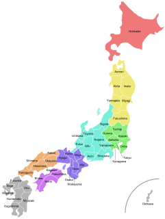
Japan is divided into 47 prefectures, which rank immediately below the national government and form the country's first level of jurisdiction and administrative division. They include 43 prefectures proper, two urban prefectures, one "circuit" or "territory" and one metropolis. In 1868, the Meiji Fuhanken sanchisei administration created the first prefectures to replace the urban and rural administrators in the parts of the country previously controlled directly by the shogunate and a few territories of rebels/shogunate loyalists who had not submitted to the new government such as Aizu/Wakamatsu. In 1871, all remaining feudal domains (han) were also transformed into prefectures, so that prefectures subdivided the whole country. In several waves of territorial consolidation, today's 47 prefectures were formed by the turn of the century. In many instances, these are contiguous with the ancient ritsuryō provinces of Japan.
A federated state is a territorial and constitutional community forming part of a federation. Such states differ from fully sovereign states, in that they do not have full sovereign powers, as the sovereign powers have been divided between the federated states and the central or federal government. Importantly, federated states do not have standing as entities of international law. Instead, the federal union as a single entity is the sovereign state for purposes of international law. Depending on the constitutional structure of a particular federation, a federated state can hold various degrees of legislative, judicial, and administrative jurisdiction over a defined geographic territory and is a form of regional government.
The National Council is one of the two houses of the Austrian Parliament and is frequently referred to as the lower house. The constitution endows the National Council with far more power than the Federal Council.

The Districts of Portugal, are the most important first-level administrative subdivisions of continental Portugal. Currently, mainland Portugal is divided into 18 districts. The Portuguese Autonomous Regions of Açores and Madeira are no longer divided into districts.
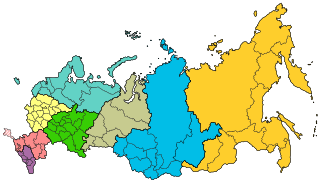
The federal districts are groupings of the federal subjects of Russia. Federal districts are not mentioned in the nation's constitution, and do not have competences of their own and do not manage regional affairs. They exist solely to monitor consistency between the federal and regional bodies of law, and ensuring governmental control over the civil service, judiciary, and federal agencies, operating in the regions.
West Vancouver—Sunshine Coast—Sea to Sky Country is a federal electoral district in British Columbia, Canada, that has been represented in the House of Commons of Canada since 1997.

Elections in Belgium are organised for legislative bodies only, and not for executive functions. Direct elections take place for the European Parliament, the Chamber of Representatives, the Parliaments of the Regions, the Parliaments of the Communities, the provincial councils, the municipal councils and the councils of Districts of Antwerp. Voting is mandatory and all elections use proportional representation which in general requires coalition governments.

The Thompson–Nicola Regional District is a regional district in the Canadian province of British Columbia. The Canada 2021 Census population was 143,680 and the area covers 44,449.49 square kilometres. The administrative offices are in the main population centre of Kamloops, which accounts for 78 percent of the regional district's population. The only other city is Merritt; other municipally-incorporated communities include the District Municipalities of Logan Lake, Barriere and Clearwater and the Villages of Chase, Ashcroft, Cache Creek, Clinton and Lytton, and also the Mountain Resort Municipality of Sun Peaks.
The country of Norway is historically divided into a number of districts. Many districts have deep historical roots, and only partially coincide with today's administrative units of counties and municipalities. The districts are defined by geographical features, often valleys, mountain ranges, fjords, plains, or coastlines, or combinations of the above. Many such regions were petty kingdoms up to the early Viking Age.

The regions of Ivory Coast are the second-level subdivisions of Ivory Coast. There are 31 regions, and each region is subdivided into two or more departments, the third-level division in Ivory Coast. Two to four regions were combined to make up a district, the first-level subdivision, that was abolished in 2014. The two autonomous districts of Ivory Coast are not divided into regions.
The general ticket, also known as party block voting (PBV) or ticket voting, is a type of block voting in which voters opt for a party, or a team's set list of candidates, and the highest-polling party/team becomes the winner. Unless specifically altered, this electoral system results in the victorious political party receiving 100% of the seats. Rarely used today, the general ticket is usually applied in more than one multi-member district, which theoretically allows regionally strong minority parties to win some seats, but the strongest party nationally still typically wins with a landslide.
This article shows the administrative divisions of Iceland.

The British Columbia Interior, popularly referred to as the BC Interior or simply the Interior, is a geographic region of the Canadian province of British Columbia. While the exact boundaries are variously defined, the British Columbia Interior is generally defined to include the 14 regional districts that do not have coastline along the Pacific Ocean or Salish Sea, and are not part of the Lower Mainland. Other boundaries may exclude parts of or even entire regional districts, or expand the definition to include the regional districts of Fraser Valley, Squamish–Lillooet, and Kitimat–Stikine.

The Greater Chennai Metropolitan Area, or simply the Chennai Metropolitan Area (CMA), is the fourth-most populous metropolitan area in India, the 22nd-most in Asia, and the 40th-most in the world. The CMA consists of the core city of Chennai, which is coterminous with the Chennai district, and its suburbs in Kanchipuram, Chengalpattu, Thiruvallur and Ranipet districts. The Chennai Metropolitan Development Authority (CMDA) is the nodal agency that handles town planning and development within the metro area. Since 1974, an area encompassing 1,189 km2 (459 sq mi) around the city has been designated as the CMA and the CMDA has been designated as the authority to plan the growth of the city and the area around it. But in October 2022 the area of CMA was expanded five-fold to 5,904 km2 (2,280 sq mi).
Mount Greylock Regional School is a public middle and high school in Williamstown, Massachusetts, within the foothills of Mount Greylock. The school is part of the Mount Greylock Regional School District.