Bobtail Mountain Provincial Park is a provincial park in British Columbia, Canada. It was established on June 29, 2000, under the Protected Areas of British Columbia Act.
Blue River Black Spruce Provincial Park is a provincial park in British Columbia, Canada.
Blue River Pine Provincial Park is a provincial park in British Columbia, Canada.
Conkle Lake Provincial Park is a provincial park in British Columbia, Canada, west of the confluence of the Kettle and West Kettle Rivers. The park size is 587 hectares. Bird species that live in the area are the common loon, merganser, ruffed grouse, pileated woodpecker, black-capped chickadee, and ruby-crowned kinglet. Mammals that live in the area are bears, squirrels, raccoons, rodents, beavers, deer, rabbits, foxes, and moose.
Cinnemousun Narrows Provincial Park is a provincial park in British Columbia, Canada, located on Shuswap Lake at the convergence of the lake's four arms.
Edge Hills Provincial Park is a provincial park in British Columbia, Canada, located west of the town of Clinton. The Edge Hills flank the wall of the Fraser Canyon north of Moran Canyon and form a small fore-range between the river and the higher Marble Range just east. Access to the Edge Hills is via the Jesmond Road, which cuts north off the Pavilion Mountain Road at Kelly Lake. A spur road from the Jesmond Road west goes to an overlook atop the Edge Hills, known as Cougar Point.
Ellison Provincial Park is a provincial park in British Columbia, Canada, located on the east side of Okanagan Lake to the south of the city of Vernon. The park contains approximately 219 hectares (2.19 km2) of land, 200 ha. of it upland, 19 ha. of it foreshore.
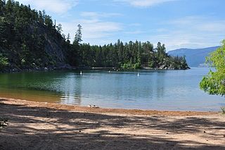
Eneas Lakes Provincial Park is a provincial park in British Columbia, Canada, located west of the town of Peachland, to the south of Peachland Creek. The park is approximately 1036 ha. in size and was established in 1968. The Eneas Lakes lie at the head of Finlay Creek.
Finn Creek Provincial Park is a provincial park in British Columbia, Canada, north of Avola and Blue River in the valley of the North Thompson River.
Keremeos Columns Park is a provincial park in British Columbia, Canada. Established in 1931, the park covers a total area of 20 hectares.

Niskonlith Lake Provincial Park is a provincial park in British Columbia, Canada, located southwest of the town of Chase. The park makes up an area of 275 hectares.
Upper Adams River Provincial Park is a provincial park in British Columbia, Canada.
Upper Violet Creek Provincial Park is a provincial park in British Columbia, Canada.

Pillar Provincial Park is a provincial park in British Columbia, Canada. It is located 11 km (6.8 mi) north of Highway 97 at Falkland. The park area is 2.34 hectares and protects a stone pillar on the hillside above Pillar Lake.
Pritchard Provincial Park is a provincial park in British Columbia, Canada, located on the north side of the South Thompson River between the communities of Monte Creek, to the west, and Chase, to the east. The park lies approximately 40 kilometres (25 mi) northeast of the city of Kamloops. The park itself is split into two geographically separated sections.

Shuswap Lake Provincial Park is a provincial park in British Columbia, Canada.
Shuswap Lake Marine Provincial Park is a provincial park in British Columbia, Canada, comprising 894 ha. The Park has a variety of amenities including boat launch ramps, picnic areas, and 27 campsites around the perimeter of Shuswap Lake. The lake's name and that of the surrounding Shuswap Country is from the Shuswap people (Secwepemc), the most northern of the Salishan speaking people.
Sunnybrae Provincial Park is a provincial park in British Columbia, Canada, located on the northern side of the Salmon Arm of Shuswap Lake, near the city of Salmon Arm. Sunnybrae is a day use park with washrooms, picnic tables, playground and swimming area.
Carcajou Pass is a mountain pass on the Continental Divide and British Columbia–Alberta boundary at the north end of Mount Robson Provincial Park. On the Alberta side lies the northwestern part of Jasper National Park. Carcajou is the French word for "wolverine".
Anarchist Protected Area is a 467-hectare (1,150-acre) park in British Columbia, Canada, with limited public access. It was established by BC Parks to increase the representation of low-elevation Douglas fir and ponderosa pine forests in the provincial protected area system. It is named after the nearby Anarchist Mountain.

