
Garibaldi Provincial Park, also called Garibaldi Park, is a wilderness park located on the coastal mainland of British Columbia, Canada, 70 kilometres (43.5 mi) north of Vancouver. It was established in 1920 and named a Class A Provincial Park of British Columbia in 1927. The park is a popular destination for outdoor recreation, with over 30,000 overnight campers and over 106,000 day users in the 2017/2018 season.

Birkenhead Lake Provincial Park is a provincial park in British Columbia, Canada, located in the Lillooet Country region. The park lies north of the communities of Squamish, Whistler and Pemberton, and immediately northwest of Birkenhead Peak and Gates Lake at the community of Birken.

Cathedral Provincial Park and Protected Area, usually known as Cathedral Provincial Park and also as Cathedral Park, is a provincial park in British Columbia, Canada. It is located east of E.C. Manning Provincial Park, south of BC Highway 3, and southeast of the town of Princeton, and southwest of Keremeos. Its southern boundary is the border with the United States. Much of the park is the basin of the Ashnola River. Cathedral Park is home to teal sub-alpine lakes, vast ridges and jarred peaks, old-growth forests, and rock formations of siltstone, granodiorite, and basalt. Hikers can scramble along various peaks such as the 8000-foot Grimface Mountain and Lakeview Mountain. Tourists flock to Smokey the Bear and Stone City because of their unique formations with incredible views formed by millennia of erosion, volcanic and tectonic activity, and glacial recession.

Kalamalka Lake Provincial Park and Protected Area is a provincial park in Coldstream, British Columbia, Canada. Located within the Okanagan region, the park encompasses a land area of about 978 hectares of pristine natural areas in the North Okanagan Regional District. Kalamalka Lake Provincial Park and Protected Area adopted its current name from Kalamalka Lake, for which it is located on its shore. During the process of entering summer, calcium carbonate forms crystals that reflect sunlight and create the vivid blue and green colours. Temperature changes in the fall and the spring sometimes create ribbons of deep blue colour in the lake, seen from the park.
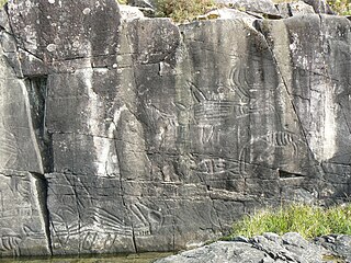
Keremeos Columns Park is a provincial park in British Columbia, Canada. Established in 1931, the park covers a total area of 20 hectares.

Little Qualicum Falls Provincial Park is a provincial park in British Columbia, Canada, on central Vancouver Island, that encompasses the entire southern shore of Cameron Lake. The Island Rail Corridor line to Port Alberni passes through the park.
Monte Lake Provincial Park is a provincial park in British Columbia, Canada, located on the east side of Monte Lake and to the south of the community of Monte Lake, British Columbia which is at the north end of the lake. About five hectares in size, it protects an area of Ponderosa pine and grasslands.
Okanagan Falls Provincial Park, now officially named sx̌ʷəx̌ʷnitkʷ Provincial Park, is a provincial park in British Columbia, Canada, located within the traditional territory of the Osoyoos Indian Band. Since time immemorial, the Osoyoos Indian Band's Okanagan ancestors have inhabited and cared for the lands and waters in their traditional territory. The park is also located within the town of Okanagan Falls, protecting the area around the waterfall of the same name, which lies below the outlet of Skaha Lake in the course of the Okanagan River.

Pillar Provincial Park is a provincial park in British Columbia, Canada. It is located 11 km (6.8 mi) north of Highway 97 at Falkland. The park area is 2.34 hectares and protects a stone pillar on the hillside above Pillar Lake.

Bowser is a community on the east coast of Vancouver Island in British Columbia, Canada. It has a population of 1,729. Approximately 66 kilometres (41 mi) north of Nanaimo, Bowser is in a region informally known as Lighthouse Country, spanning a stretch of highway that extends from Qualicum Beach in the south to Horne Lake to the west and Fanny Bay in the north and east to Denman and Hornby Islands. Bowser is in the Regional District of Nanaimo and in its Electoral Area H, one of eight in the District. The community was named after William J. Bowser, premier of British Columbia from 1915 to 1916. Bowser is served by the coast-spanning Island Highway.
Sproat Lake Provincial Park is a provincial park near Port Alberni in British Columbia, Canada's Vancouver Island. Its name derives from a lake named after 19th century entrepreneur and colonial official Gilbert Malcolm Sproat.
Sunnybrae Provincial Park is a provincial park in British Columbia, Canada, located on the northern side of the Salmon Arm of Shuswap Lake, near the city of Salmon Arm. Sunnybrae is a day use park with washrooms, picnic tables, playground and swimming area.
Tweedsmuir South Provincial Park is a provincial park covering parts of the eastern Kitimat Ranges, northern Pacific Ranges, and the Rainbow Range in British Columbia, Canada. It was established on May 21, 1938 in the western interior of the province, to protect its important natural features. The park hosts a variety of recreation activities for visitors. This park encompasses a range of diverse species in this park including bears, moose, and various fish. There are also a few at risk species in this park.
The Lower Similkameen Indian Band or Lower Smelqmix, is a First Nations band government in the Canadian province of British Columbia. Their office was in the village of Keremeos in the Similkameen region, until 2015 when they moved into their own $7million multi-purpose facility south of Cawston. They are a member of the Okanagan Nation Alliance.

The Churn Creek Protected Area is a 36,747-hectare (90,800-acre) provincial protected area in British Columbia, Canada. It is a mix of dryland canyon and steppe and adjoining rangeland flanking the canyon of Churn Creek and that stream's confluence with the Fraser River at the northern apex of the Camelsfoot Range. The historic Gang Ranch is just north of the Churn Creek Protected Area. The Empire Valley Ranch ecological preserve was added to the Protected Area in an expansion.

West Kelowna, formerly known as Westside and colloquially known as Westbank, is a city in British Columbia's Okanagan Valley on the west shore of Okanagan Lake. The city encompasses several neighbourhoods, including Casa Loma, Gellatly, Glenrosa, Lakeview Heights, Shannon Lake, Smith Creek, Rose Valley, Westbank, and West Kelowna Estates. As of 2021, West Kelowna had an estimated population of 36,078.
Robson Bight is a small Vancouver Island bay at the west end of Johnstone Strait across from West Cracroft Island in British Columbia, Canada that includes a protected killer whale habitat famous for its whale-rubbing beaches. The bight is adjacent to Lower Tsitika River Provincial Park. The nearest access point is Telegraph Cove on the east coast of Northern Vancouver Island.
Testalinden Creek is a watercourse that flows east into the Okanagan River, south of the Okanagan town of Oliver, British Columbia. The Testalinden Dam was at the headwaters of this creek prior to the dam's failure in June 2010.
South Okanagan—Similkameen National Park Reserve is a proposed national park reserve in the Regional District of Okanagan-Similkameen of British Columbia. The goal of the park is to work with the local First Nations to protect a large patch of Okanagan dry forests and part of the northern reach of the Columbia Plateau ecoregion in Canada.

