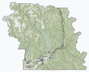
Berg Lake is a lake on the Robson River just below the river's source located within Mount Robson Provincial Park, at the doorstep of the north face of Mount Robson, the highest peak in the Canadian Rockies. It is partly fed by the Berg Glacier.
Mount Robson Provincial Park is a provincial park in the Canadian Rockies with an area of 2,249 km2. The park is located entirely within British Columbia, bordering Jasper National Park in Alberta. The B.C. legislature created the park in 1913, the same year as the first ascent of Mount Robson by a party led by Conrad Kain. It is the second oldest park in the provincial system. The park is named for Mount Robson, which has the highest point in the Canadian Rockies and is located entirely within the park.

Garibaldi Provincial Park, also called Garibaldi Park, is a wilderness park located on the coastal mainland of British Columbia, Canada, 70 kilometres (43.5 mi) north of Vancouver. It was established in 1920 and named a Class A Provincial Park of British Columbia in 1927. The park is a popular destination for outdoor recreation, with over 30,000 overnight campers and over 106,000 day users in the 2017/2018 season.

Coquihalla Canyon Park is on the north shore of the Coquihalla River in southwestern British Columbia. This provincial park includes the Othello Tunnels to the east and the mouth of the Nicolum River to the south. The tunnels were part of the Kettle Valley Railway (KV). Off Othello Rd, the locality is by road about 8 kilometres (5 mi) east of Hope.
Liard River Hot Springs Provincial Park is a provincial park in British Columbia, Canada. It is home to the second largest natural hot springs in Canada, after Deer River Hot Springs 15 km to the north east. It is a natural river of hot water rather than a spring fed man made pool. The park is part of the larger Muskwa-Kechika Management Area. The community of Liard River, British Columbia is located nearby.
Babine Lake Marine Park is on Babine Lake, which borders the Skeena and Omineca regions of central British Columbia. This provincial park comprises six separate sites around the lake. Vehicle access to the lake, via BC Highway 16 and Nilkitkwa forestry service road, is by road about 105 kilometres (65 mi) northeast of Smithers; via BC Highway 16 and Central Babine Lake Highway, is about 132 kilometres (82 mi) east of Smithers; or via Babine Lake Road, is about 20 kilometres (12 mi) northeast of Burns Lake.
Beatton Provincial Park is a provincial park in the Peace River Country of northeastern British Columbia, Canada. It is located on the Eastern shores of Charlie Lake approximately sixteen kilometers from Fort St John, BC. The 320 hectare provincial park offers facilities that include vehicle accessible camping, boat launch, drinking water, picnic area, pit toilets, playground and a large trail system. The provincial campground only operates between May and September, but the park trail system is open year-round. The park's large trail network is maintained by the Whiskey Jack Nordic Ski Club and is used for cross-country skiing and snowshoeing in the winter and hiking in the summer. There are over 20 km of groomed cross-country ski trails designed for beginner, intermediate and advancing skiers and a toboggan hill located near the parking at the main gate.

Golden Ears Provincial Park is a 555.9 square kilometres (214.6 sq mi) provincial park in British Columbia, Canada. It is named after the prominent twin peaks, which are commonly referred to as Golden Ears. The park was originally part of Garibaldi Provincial Park but was split off as a separate park in 1967. The area was logged extensively in the 1920s by the Lougheed and Abernathy Logging Company. Many recreational attractions are found within the park. Golden Ears Provincial Park is a protected area that contains many endangered species of flora and fauna.

E.C. Manning Provincial Park is a provincial park in British Columbia, Canada. It is usually referred to as Manning Park, although that nomenclature is also used to refer to the resort and ski area at the park's core. The park covers 83,671 hectares (323 mi2) and was the second most visited provincial park in 2017-18 after Cypress Provincial Park. The park lies along British Columbia Highway 3, and occupies a large amount of land between Hope and Princeton along the Canada-United States border.

Englishman River Falls Provincial Park is a provincial park in British Columbia, Canada. It is located west of Parksville and borders the small community of Errington on Vancouver Island.
French Beach Provincial Park is a provincial park located on Vancouver Island, between Sooke and Jordan River, British Columbia. The area has a day use parking lot and B.C. provincial campground. It was created in 1980 as the first family-oriented park on the southwest coast of Vancouver Island. Situated on the scenic Strait of Juan de Fuca on the west coast of southern Vancouver Island, French Beach Provincial Park offers views of the Strait and the Olympic Mountains. The beach spreads on 1,600-meters and is a location for whale watching as well as spotting Bald eagles, Ospreys and a variety of seabirds.
Kikomun Creek Provincial Park is a provincial park in British Columbia, Canada.

Marble Canyon Provincial Park is a provincial park in British Columbia, Canada, established in 1956 to protect Marble Canyon, a limestone formation at the south end of the Marble Range. In 2001 the park was expanded to 355 hectares to include all of Pavilion Lake due to the presence of microbialites, a type of stromatolite important to research into astrobiology and other fields, and in 2010, it was further expanded to 2,544 hectares.

Miracle Beach Provincial Park is a provincial park on the eastern shore of Vancouver Island in British Columbia, Canada. Located between Comox and Campbell River, the park includes a foreshore area in the Strait of Georgia, much of the Black Creek estuary, and a forested area. According to its Master Plan, it fulfills primarily a recreational role with a focus on beach play, picnicking, nature appreciation, and camping, and a secondary conservation role with a focus on the natural shoreline and estuary. In support of its recreational focus the park is developed with a day-use parking area with accessible trails leading to the shoreline and a camping area with 200 drive-in sites. The park is also hosts a nature centre building and a sheltered group picnic shelter. Vegetation in the park is typical for the region's second-growth forests with Douglas-fir most prominent. Common associates include Western hemlock, Sitka spruce, red alder and bigleaf maple. Salal and sword fern are the most abundant shrub. Black Creek, which flows through the park, is a spawning area for coho salmon.
Monkman Provincial Park is a provincial park in British Columbia, southwest of Tumbler Ridge and northeast of Hansard. Like Monkman Pass, Monkman Lake, Monkman Creek and Monkman Falls, it was named after Alexander Monkman.

Rathtrevor Beach Provincial Park is a provincial park in Parksville, British Columbia, Canada. Located at the east end of the town, the 347-hectare park features a two-kilometre long stretch of sandy beach, a stand of old-growth Douglas fir trees and 250 vehicle-accessible and 25 walk-in camping spaces. Popular year-round, the park is easily accessible from Highway 19. The sandy beach is the main attraction. At low tide, it stretches nearly a kilometre out into the Strait of Georgia.

Shannon Falls Provincial Park is a provincial park in British Columbia, Canada. It is located 58 kilometers (36 mi) from Vancouver and 2 kilometers (1.2 mi) south of Squamish along the Sea to Sky Highway.

Skihist Provincial Park is a provincial park in British Columbia, Canada, located on the Thompson River and adjacent to the Trans-Canada Highway #1 between the towns of Lytton (W) and Spences Bridge (E). The park is named for Skihist Mountain, which is visible from the park though on the opposite side of the Fraser River to the west of Lytton.

Spahats Creek Falls, also called Spahats Falls, is a waterfall on Spahats Creek within Wells Gray Provincial Park of British Columbia, Canada. Common references place the falls at around 60 m (197 ft) tall, but taking into account the second tier, it is closer to 75–80 meters tall. It is a popular stop for tourists and especially motorcoach tours since it is only 10 km (6.2 mi) off the busy Yellowhead Highway.