
Northern Manitoba is a geographic and cultural region of the Canadian province of Manitoba. Originally encompassing a small square around the Red River Colony, the province was extended north to the 60th parallel in 1912. The region's specific boundaries vary, as "northern" communities are considered to share certain social and geographic characteristics, regardless of latitude.
Bearhole Lake Provincial Park is a provincial park in British Columbia, Canada, 5 km east of the mining community of Tumbler Ridge, on the Alberta Plateau. Established in January 2001, the park includes 12,705 ha of land in the Boreal White and Black Spruce biogeoclimatic zones within the Kiskatinaw Plateau. It is transition zone with mixed wood forests including spruce, pine, and larch. Bearhole Lake, the headwaters of the Kiskatinaw River provides habitat for trumpeter swans, yellow perch, burbot, rainbow trout, and northern pike.
Burns Lake Park is a provincial park in British Columbia, Canada, located near the town of Burns Lake. The park was established per Order in Council 63 on January 25, 2001, and constitutes approximately 65 hectares.
Bonaparte Provincial Park is an 11,811 hectare provincial park in British Columbia, Canada. It is located within the Bonaparte Plateau.
Chase Provincial Park is a provincial park in British Columbia, Canada, located around Carina and Tomias Lakes, 70 kilometres (43 mi) north of Germansen Landing in the Omineca Mountains and just west of the Finlay Arm of Williston Lake. Approximately 32,226 hectares (124.43 sq mi), it was established in 2001.
Ethel F. Wilson Memorial Provincial Park is a provincial park in central British Columbia, Canada. The park is situated on the northern tip of Pinkut Lake. Activities in the park include rainbow trout fishing and boating. The park has five campsites that are allocated on a first-come first-served basis. The area of the park is 33 hectares.
Ed Bird – Estella Lakes Provincial Park is a provincial park in British Columbia, Canada.
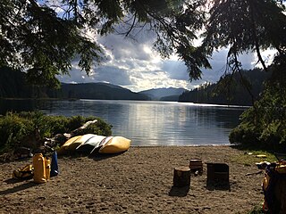
Loveland Bay Provincial Park is a provincial park on Vancouver Island, British Columbia, Canada, located on the north side of Campbell Lake, just west of the city of Campbell River.
Lower Tsitika River Provincial Park is a provincial park in British Columbia, Canada.
Main Lake Provincial Park is a provincial park on Quadra Island in British Columbia, Canada. Established in 1996 as Main Lakes Chain Park and renamed and expanded in 1997, the park encompasses a large wilderness area of six lakes with many diverse animal, bird and plant species. Opportunities for visitor observation and outdoor recreation include wilderness camping, canoeing, kayaking and hiking. Main Lake, Village Bay Lake and Mine Lake are connected by narrow, shallow marshes. Clear Lake, Stramberg Lake and Little Main Lake are accessible by hiking or rough portage.
Moberly Lake Provincial Park is a provincial park in British Columbia, Canada.
Muscovite Lakes Provincial Park is a provincial park in British Columbia, Canada. It is located on the western shore of Lake Williston, about 125 kilometres (78 mi) north of Mackenzie.
Uncha Mountain Red Hills Provincial Park is a provincial park in British Columbia, Canada, comprising two parcels of land on the north and south shores of Francois Lake. Total area of the park is 9,421 hectares.
Rubyrock Lake Provincial Park is a provincial park in British Columbia, Canada. More information on the park can be found on the BC Parks website.
Stuart Lake Marine Provincial Park is a provincial park in British Columbia, Canada.
Sutherland River Provincial Park and Protected Area is a provincial park in British Columbia, Canada.
Takla Lake Marine Provincial Park is a provincial park in British Columbia, Canada. Located northeast of the town of Smithers and roughly parallel to Babine Lake to its west/southwest, it comprises three sites on Takla Lake in the northwestern part of the Omineca Country of the province's North-Central Interior. The three sites are the Sandy Point Site, containing about 160 ha, Takla Lake West containing about 41 ha, and White Bluff, containing about 349 ha.
Taylor Arm Provincial Park is a provincial park in British Columbia, Canada, located on the north side of Sproat Lake 23 km northwest of Port Alberni on Vancouver Island. Situated along Highway 4, the 71-hectare park has few services but provides group camping sites, undeveloped beaches, and day-use areas. The group camping site has pit toilets and a hand pump water supply, and is connected to the lake shore via a trail that passes under the highway.
Trembleur Lake Provincial Park is a provincial park in British Columbia, Canada.

Lac La Ronge Provincial Park is located in the boreal forest of the north central part of the Canadian province of Saskatchewan within the Canadian Shield. Situated in the Churchill River system, this provincial park has close to 100 lakes and more than 30 canoe routes, many of which follow old fur trade routes. Summer activities include camping, hiking, boating, fishing, and swimming. In the winter, there's cross-country skiing, snowmobiling, and ice fishing. Saskatchewan's highest waterfall is in the park. Nistowiak Falls are located north of Lac La Ronge along the Rapid River.

