The Municipality and Borough of Skagway is a first-class borough in Alaska on the Alaska Panhandle. As of the 2020 census, the population was 1,240, up from 968 in 2010. The population doubles in the summer tourist season in order to deal with more than 1,000,000 visitors each year. Incorporated as a borough on June 25, 2007, it was previously a city in the Skagway-Yakutat-Angoon Census Area. The most populated community is the census-designated place of Skagway.

The Klondike Gold Rush was a migration by an estimated 100,000 prospectors to the Klondike region of Yukon, in north-western Canada, between 1896 and 1899. Gold was discovered there by local miners on August 16, 1896; when news reached Seattle and San Francisco the following year, it triggered a stampede of prospectors. Some became wealthy, but the majority went in vain. It has been immortalized in films, literature, and photographs.

The White Pass and Yukon Route is a Canadian and U.S. Class III 3 ft narrow-gauge railroad linking the port of Skagway, Alaska, with Whitehorse, the capital of Yukon. An isolated system, it has no direct connection to any other railroad. Equipment, freight and passengers are ferried by ship through the Port of Skagway, and via road through a few of the stops along its route.

The Chilkoot Trail is a 33-mile (53 km) trail through the Coast Mountains that leads from Dyea, Alaska, in the United States, to Bennett, British Columbia, in Canada.
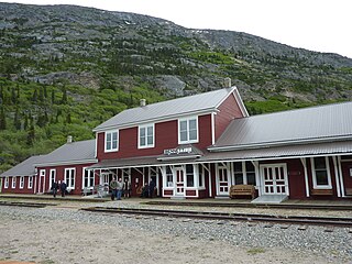
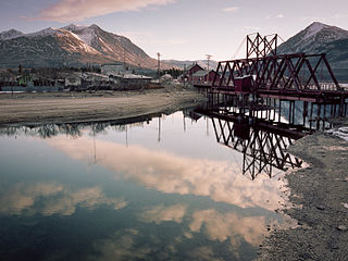
Bennett, British Columbia, Canada, is an abandoned town next to Bennett Lake and along Lindeman Creek. The townsite is now part of the Chilkoot Trail National Historic Site of Canada and is managed by Parks Canada. Bennett is also a stop on the White Pass and Yukon Route railroad during the summer months.
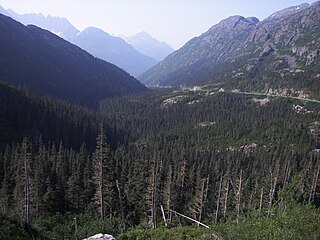
White Pass, also known as the Dead Horse Trail, is a mountain pass through the Boundary Ranges of the Coast Mountains on the border of the U.S. state of Alaska and the province of British Columbia, Canada. It leads from Skagway, Alaska, to the chain of lakes at the headwaters of the Yukon River, Crater Lake, Lake Lindeman, and Bennett Lake.
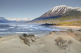
Carcross, originally known as Caribou Crossing, is an unincorporated community in Yukon, Canada, on Bennett Lake and Nares Lake. It is home to the Carcross/Tagish First Nation.
The Klondike Highway is a highway that runs from the Alaska Panhandle through the province of British Columbia and the territory of Yukon in Canada, linking the coastal town of Skagway, Alaska, to Dawson City, Yukon. Its route somewhat parallels the route used by prospectors in the 1898 Klondike Gold Rush.
Tagish Lake is a lake in Yukon and northern British Columbia, Canada. The lake is more than 100 km (62 mi) long and about 2 km (1 mi) wide.

Klondike Gold Rush National Historical Park is a national historical park operated by the National Park Service that seeks to commemorate the Klondike Gold Rush of the late 1890s. Though the gold fields that were the ultimate goal of the stampeders lay in the Yukon Territory, the park comprises staging areas for the trek there and the routes leading in its direction. There are four units, including three in Municipality of Skagway Borough, Alaska and a fourth in the Pioneer Square National Historic District in Seattle, Washington.

Nares Lake is a lake in the southern Yukon between Bennett Lake and Tagish Lake that lies below Nares Mountain. Nares Lake is in fact an arm of Tagish Lake. The community of Carcross is on the Nares Narrows between Bennett and Tagish Lake, along the Klondike Highway. The primary inflow to and outflow from the lake is the Nares River. Both the river and the lake are named after Admiral George Nares.

Keish, also known as James Mason and by the nickname Skookum Jim Mason, was a member of the Tagish First Nation in what became the Yukon Territory of Canada. He was born near Bennett Lake on what is now the British Columbia and Yukon border. He lived in Caribou Crossing, now Carcross, Yukon, Canada.

The Tagish Highland is an upland area on the inland side of the northernmost Boundary Ranges of the Coast Mountains, spanning far northwestern British Columbia from Atlin Lake to the area of the pass at Champagne, Yukon between the Alsek and Yukon Rivers. In some classification systems, and in local terminology, the Tagish Highland is considered to be part of the Boundary Ranges, as is the neighbouring Tahltan Highland to its south. As classified by the Canadian Mountain Encyclopedia per S. Holland, the Tagish Highland is part of the system unofficially described as the Interior Mountains.
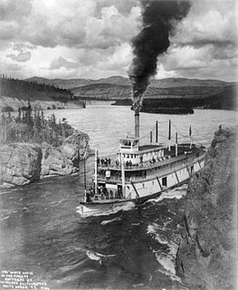
Steamboats on the Yukon River played a role in the development of Alaska and Yukon. Access to the interior of Alaska and Yukon was hindered by large mountains and distance, but the wide Yukon River provided a feasible route. The first steamers on the lower Yukon River were work boats for the Collins Overland Telegraph in 1866 or 1867, with a small steamer called Wilder. The mouth of the Yukon River is far to the west at St. Michael and a journey from Seattle or San Francisco covered some 4,000 miles (6,400 km).

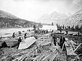
Lindeman Lake, also known as Lake Lindeman, is a lake on the Chilkoot Trail in far northwestern British Columbia, Canada. It is just south of Bennett Lake and northeast of the summit of the Chilkoot Pass. From the direction of the pass it is fed by Lindeman Creek, which connects the two lakes. Lake Lindeman and Lake Bennett were key components of the Chilkoot Trail during the Klondike Gold Rush, with both seeing hundreds of vessels built to transit their waters and camp-town "tent cities" established on their shores. Lindeman was located at the south end of Lindeman Lake, while Bennett, often known as Bennett City, was at the south end of Lake Bennett.
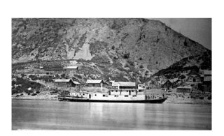
Steamboats operated on the Stikine River in response to gold finds in along that river and in the Cassiar Country of northwestern British Columbia, Canada.

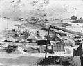
Eric A. Hegg was a Swedish-American photographer who portrayed the people in Skagway, Bennett and Dawson City during the Klondike Gold Rush from 1897 to 1901. Hegg himself participated in prospecting expeditions with his brother and fellow Swedes while documenting the daily life and hardships of the gold diggers.

The Skagway–Fraser Border Crossing connects the communities of Skagway, Alaska and Carcross, Yukon on the Canada–United States border. Alaska Highway 98 on the American side joins Yukon Highway 2 on the Canadian side. The border is near the summit of White Pass on the Klondike Highway, where the elevation is 3,292 feet (1,003 m). The border divides Alaska Time Zone from Pacific Time Zone. The highway, completed in 1979, was seasonal, but has been open year-round since 1986.
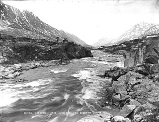
Lindeman Creek, formerly known as One Mile River connects Bennett Lake to Lindeman Lake, areas on the Chilkoot Trail in far northwestern British Columbia, Canada.