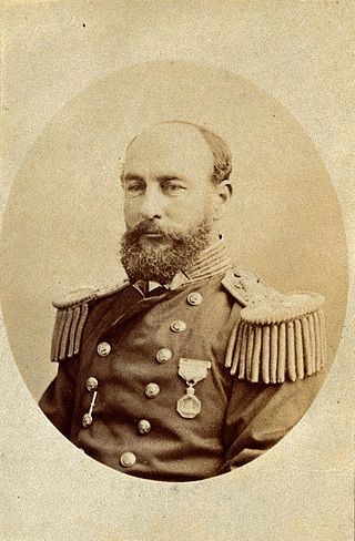
Vice-Admiral Sir George Strong Nares was a Royal Navy officer and Arctic explorer. He commanded the Challenger Expedition, and the British Arctic Expedition. He was highly thought of as a leader and scientific explorer. In later life he worked for the Board of Trade and as Acting Conservator of the River Mersey.

Bennett Lake is a lake in the Province of British Columbia and Yukon Territory in northwestern Canada, at an elevation of 642 m (2,106 ft). It is just north of the border with the United States state of Alaska, near the Alaskan port of Skagway.
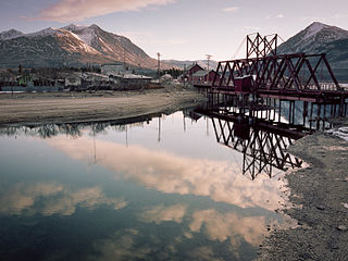
Carcross, originally known as Caribou Crossing, is an unincorporated community in Yukon, Canada, on Bennett Lake and Nares Lake. It is home to the Carcross/Tagish First Nation.
Tagish Lake is a lake in Yukon and northern British Columbia, Canada. The lake is more than 100 km (62 mi) long and about 2 km (1 mi) wide.
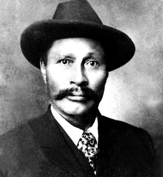
Keish, also known as James Mason and by the nickname Skookum Jim Mason, was a member of the Tagish First Nation in what became the Yukon Territory of Canada. He was born near Bennett Lake, on what is now the Yukon–British Columbia border. He lived in Caribou Crossing, now Carcross, Yukon.
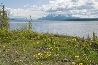
Atlin Lake is the largest natural lake in the province of British Columbia, Canada. The northern tip of the lake is in Yukon, as is Little Atlin Lake. However, most of the lake lies within the Atlin District of British Columbia. Atlin Lake is generally considered to be the source of the Yukon River although it is drained via the short Atlin River into Tagish Lake. Atlin Lake was named by the Tlingit First Nation people of the region.
Tagish was a language spoken by the Tagish or Carcross-Tagish, a First Nations people that historically lived in the Northwest Territories and Yukon in Canada. The name Tagish derives from /ta:gizi dene/, or "Tagish people", which is how they refer to themselves, where /ta:gizi/ is a place name meaning "it is breaking up.
Tagish is an unincorporated community in Yukon, Canada. It is 30 kilometres (19 mi) east of Carcross, Yukon, on the Tagish Road at the northern end of Tagish Lake. The greater Tagish area also includes the Tagish Estates, Tagish Beach and Taku subdivisions, the latter two developed for cottages but now serving for many year-round homes. Tagish Beach and Taku have their own community hall. The Tagish Road was built in 1942 as part of an oil pipeline project, and the community sprouted around a bridge built over the narrow water between Tagish Lake and Marsh Lake.

The Tagish Highland is an upland area on the inland side of the northernmost Boundary Ranges of the Coast Mountains, spanning far northwestern British Columbia from Atlin Lake to the area of the pass at Champagne, Yukon between the Alsek and Yukon Rivers. In some classification systems, and in local terminology, the Tagish Highland is considered to be part of the Boundary Ranges, as is the neighbouring Tahltan Highland to its south. As classified by the Canadian Mountain Encyclopedia per S. Holland, the Tagish Highland is part of the system unofficially described as the Interior Mountains.
The Atlin District, also known as the Atlin Country, is a historical region located in the far northwestern corner of the Canadian province of British Columbia, centered on Atlin Lake and the gold-rush capital of the region, the town of Atlin. The term "Atlin District" was also used synonymously with the official administrative area named the Atlin Mining District, established during the gold-mining heyday contemporaneous with the Klondike Gold Rush. The region also includes adjoining Teslin and Tagish Lakes and the Bennett Lake area in the narrow strip of BC separating the Alaska Panhandle from the Yukon. The Atlin District is currently part of the Stikine Region in the regional district system. The communities of the Atlin Lakes district, as the area is casually called, are referred to in national weather reports as "the Southern Lakes", as in "Whitehorse and the Southern Lakes", although this also includes towns on the Yukon end of the lakes.
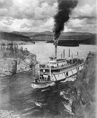
Steamboats on the Yukon River played a role in the development of Alaska and Yukon. Access to the interior of Alaska and Yukon was hindered by large mountains and distance, but the wide Yukon River provided a feasible route. The first steamers on the lower Yukon River were work boats for the Collins Overland Telegraph in 1866 or 1867, with a small steamer called Wilder. The mouth of the Yukon River is far to the west at St. Michael and a journey from Seattle or San Francisco covered some 4,000 miles (6,400 km).
Teslin Lake is a large lake spanning the border between British Columbia and Yukon, Canada. It is one of a group of large lakes in the region of far northwestern BC, east of the upper Alaska Panhandle, which are the southern extremity of the basin of the Yukon River, and which are known in Yukon as "the Southern Lakes". The lake is fed and drained primarily by the Teslin River, south and north, but is also fed from the east by the Jennings River and the Swift River, and from the west by the Hayes River.
The Yukon Plateau is a plateau located in the Yukon Territory, comprising much of the central and southern Yukon Territory and the far northern part of British Columbia, Canada between Tagish Lake (W) and the Cassiar Mountains (E) and north of the Nakina River.
The Bennett Range is a subrange of the Tagish Highland, located on the west side of Bennett Lake in Yukon and British Columbia, Canada.
Kusawa Lake is a lake in the southern Yukon, Canada. Kusawa means "long narrow lake" in the Tlingit language. The Kusawa Lake is a lake in Canada's Yukon Territory. It is located at an altitude of 671 m (2,201 ft) and is 60 km (37 mi) southwest of Whitehorse near the British Columbia border. It meanders over a length of 75 km (47 mi) with a maximum width of about 2.5 km (1.6 mi) through the mountains in the north of the Boundary Ranges. It is fed by the Primrose River and Kusawa River. The Takhini outflows to the Yukon River from the northern tip of Kusawa Lake. Kusawa Lake has an area of 142 km2 (55 sq mi). The lake has a maximum depth of 140 m (460 ft) and is of glacial origin. It is a common tourist destination and is also popular for fishing.
The Partridge River is a river in the Yukon and British Columbia, Canada. It is in the Bering Sea drainage basin and is a tributary of Bennett Lake.
The Nares River is a river in the Yukon and British Columbia, Canada. It is in the Bering Sea drainage basin, is a tributary of Tagish Lake, and is named for George Nares, a naval officer.
Partridge Lake is a lake in the Yukon and British Columbia, Canada that is part of the Bering Sea drainage basin. The primary inflow, at the south, and outflow, at the north, is the Partridge River, which flows via Bennett Lake, the Nares River, Tagish Lake, the Tagish River and the Yukon River to the Bering Sea. A secondary inflow, at the southwest, is Jones Creek.

