Wreck Beach

Last updated
A nudist stands beside the Wreck Beach sign at trail 6 next to the UBC campus. The clothing optional Wreck Beach is in the background. Wreck Beach in Vancouver.jpg
A nudist stands beside the Wreck Beach sign at trail 6 next to the UBC campus. The clothing optional Wreck Beach is in the background.
The view north from Acadia Beach. Acadianorth.jpg
The view north from Acadia Beach.
Wreck Beach Map. WreckBeach.jpg
Wreck Beach Map.

Wreck Beach (Squamish: Ts'at'lhm) is a clothing-optional beach located in Pacific Spirit Regional Park, which is in turn part of the University Endowment Lands just west of Vancouver, British Columbia, Canada. The clothing-optional section is clearly marked with signs and stretches approximately 6.7 kilometres or 4.2 miles from Acadia Beach, in the north, to the Booming Grounds Creek on the north arm of the Fraser River. The park is administered by the Greater Vancouver Regional District (GVRD), though Indigenous claims are repeatedly asserted, especially by the Musqueam Nation.

Contents

History

The earliest evidence of Indigenous peoples inhabitation dates back to 13,000 B.C. being the hunting, fishing, logging, spiritual connection grounds for the Musqueam, referred to as “Ulksen” or “the nose”. [1] The beach is man-made, reclaimed from the sea in a joint venture with the Canadian Army and UBC to train cadets for beach landings in WWI, hence the presence of the "instrument towers". In the Great Depression, nude bathing became popular due to high costs of swimsuits with men congregating on Siwash Rock in Stanley Park, in order to escape the puritanicalist oppression of local residents, a legacy of the Victorian era, they then flocked to Wreck Beach. The beach increased in popularity with hippies until the late 1960s when a police raid in 1970 yielded a dozen arrests. The Georgia Straight staged a nude-in protest with 3,000 showing up and the charges were dropped, with the police designating the area as a "no-harm, no-foul zone" until 1991 when it was officially designated a legally recognised nudist beach. [2] On January 25, 1977, the Citizens Concerned for Coward's Cove was formally established, then changed to Wreck Beach Committee, then to the Wreck Beach Preservation Society in 1983. The WBPS has fought against these developments: a 20-million cubic meter dredging operation behind the North Arm breakwater; a parallel trail from Trail 6 to Trail 7 (One already built there quietly by two unknowns); a proposal to barge millions of gallons of "jet-fuel A" past Wreck Beach weekly; toe-to-cliff-top condominiums (proposed in 2004); [3] a 20-foot high, 10-foot wide sea wall over the beach it would supposedly have been meant to protect; viewing platforms which would have changed the interpretation of the Canadian Criminal Code insofar as nudity was concerned; the cutting of 40-acres of cliff face forest and then, the shaving of the cliffs in those 40-acres, and the construction of an RCMP service road to and along the beach. Current threats to the beach area include a restaurant overlooking the beach, the elimination of all curb-side parking, the grassing in of Marine Drive, and possible washrooms on the beach level instead of above and out of sight of the beach. [4] In 2012, permanent toilet outhouses were installed. [5]

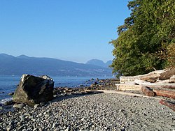
Acadia Beach – Tower Beach – Point Grey

WW2 Instrument Tower. WreckBeachTower.jpg
WW2 Instrument Tower.

The shoreline throughout these beaches is mainly rocky with some sandy stretches with fewer beach-goers. An area is provided for owners to have their dogs off leash. During the smelt season, naturists share this area with nude fishers and their families. Smelt fishing is typically prohibited from the middle of June to the middle of August.

Acadia Beach is short walk down a gentle slope from the parking lot on Marine Drive where there is a grassy area with several picnic tables. Tower Beach is at the end of the much longer Trail 3 and Point Grey is near the steeper Trail 4. There is pay parking close to Trail 3 and 4 at the Museum of Anthropology. All of Wreck Beach is contiguous and it is possible to walk along the entire coastline. However, when the tide is too high, access can be limited.

Along Tower Beach are two tall concrete range/direction instrument towers that are relics from World War II.

Along with lush vegetation, various forms of wildlife can also be seen, including nesting herons, sea lions, kingfishers, and bald eagles.

Wreck Beach proper and Trail 6

View of Point Grey from Wreck Beach proper. Wreckbeach-ptgrey.jpg
View of Point Grey from Wreck Beach proper.
Looking south from the large sandy area near trail 6. Wreck Beach looking south.jpg
Looking south from the large sandy area near trail 6.

While the entire 7 km beach around to Point Grey from Acadia Beach to Booming Ground Creek is often referred to as Wreck Beach, the large sandy area on the north side of the North Arm Breakwater at the base of Trail 6 is what many think of when they talk about Wreck Beach. The trail is the most developed of the trails down the bluff and has 490 wooden steps set into the soil. At the bottom of Trail 6 is the most popular portion of the beach, a stretch of sand between two artificial rock jetties constructed as breakwaters, lined by a row of licensed vendors selling imported clothing, jewelry, drinks, snacks, and other beach related items. Other unlicensed vendors may be found wandering the beach selling alcoholic beverages.

Clothing is optional throughout Wreck Beach. [6] Due to Wreck Beach's proximity to the University of British Columbia, many students and some faculty and staff visit the beach. In recent years many beach users have objected, on both privacy and environmental grounds, to the university's plans to construct new buildings close to the cliff edge and partially overlooking the beach.

Wreck22.jpg

Swimming and ocean water quality

Swimming is popular at Wreck Beach, primarily as brief "dips" for beachgoers to cool off. Since the ocean water is quite cold, swimming far from shore without a wetsuit and partner is not advised. Ocean waves in the summer, when present, are quite small and usually do not pose a risk to swimmers or waders. Rip currents are not known to be a problem and advisories are not usually posted. Caution should be taken when diving or jumping into the water to avoid any submerged rocks. Adverse interactions with marine wildlife or flora are unlikely, but jellyfish should be avoided as a precautionary measure. Small pleasure boats may anchor close to the beach and swimmers should avoid potential collisions with them.

A few times over the years, Metro Vancouver health authorities have issued advisories that the ocean's coliform bacteria counts near the beach are relatively high, and there may be potential risk to swimmers. However, Wreck Beach tends to have lower counts than many Vancouver beaches and gastrointestinal illness is generally unlikely.


See also

Looking at the Strait of Georgia from a Wreck Beach path. Wreckbeach-georgiastrait.jpg
Looking at the Strait of Georgia from a Wreck Beach path.

Related Research Articles

<span class="mw-page-title-main">Naturism</span> Practice and advocacy of social nudity

Naturism is a lifestyle of practicing non-sexual social nudity in private and in public; the word also refers to the cultural movement which advocates and defends that lifestyle. Both may alternatively be called nudism. Though the two terms are broadly interchangeable, nudism emphasizes the practice of nudity, whilst naturism highlights an attitude favoring harmony with nature and respect for the environment, into which that practice is integrated. That said, naturists come from a range of philosophical and cultural backgrounds; there is no single naturist ideology.

<span class="mw-page-title-main">Pacific Spirit Regional Park</span> Park in the city of Vancouver, British Columbia

Pacific Spirit Regional Park is a 874 hectares park located in the University Endowment Lands, on Point Grey to the west of the city of Vancouver, British Columbia. It surrounds the endowment lands of the University of British Columbia on the shores of Georgia Strait in the Pacific Ocean. It is a nature preserve of the British Columbia government and classified under Electoral Area A.

<span class="mw-page-title-main">Hippie Hollow Park</span> Park in the United States

Hippie Hollow Park is a park located on the shore of Lake Travis in northwest Austin. It is the only legally recognized clothing-optional public park in the State of Texas. Though the land is owned by the Lower Colorado River Authority, it is leased to Travis County, whose Parks Department has administered the park since 1985. Sometimes erroneously labeled as a beach, the park actually sits on a somewhat steep slope above Lake Travis with limestone steps that can be quite rugged in some spots. Depending on the water level of the lake, access to the water may require some rock climbing.

<span class="mw-page-title-main">Black's Beach</span> Nude beach near San Diego, California, United States

Black's Beach is a secluded section of beach beneath the bluffs of Torrey Pines on the Pacific Ocean in La Jolla, San Diego, California, United States. It is officially part of Torrey Pines State Beach. The northern portion of Black's Beach is owned and managed by the California Department of Parks and Recreation, while the southern portion of the beach, officially known as Torrey Pines City Beach, is jointly owned by the city of San Diego and the state park, but is managed by the city of San Diego. This distinction is important as Black's Beach is most known as a nude beach, a practice that is now prohibited in the southern portion managed by the city of San Diego.

<span class="mw-page-title-main">Hanlan's Point Beach</span> Nude beach in Toronto, Canada

Hanlan's Point Beach is a nude beach on the western side of the Toronto Islands in Toronto, Ontario on the shore of Lake Ontario.

Playa Zipolite is a beach community located in San Pedro Pochutla municipality on the southern coast of Oaxaca state in Mexico between Huatulco and Puerto Escondido.

<span class="mw-page-title-main">Nude recreation</span> Leisure activity while naked

Nude recreation consists of recreational activities which some people engage in while nude. Historically, the ancient Olympic Games were nude events. There remain some societies in Africa, Oceania, and South America that continue to engage in everyday public activities—including sports—without clothes, while in most of the world nude activities take place in either private spaces or separate clothing optional areas in public spaces. Occasional events, such as nude bike rides, may occur in public areas where nudity is not otherwise allowed.

Point Grey is a headland marking the southern entrance to English Bay and Burrard Inlet. The headland is the site of Wreck Beach, Tower Beach, Point Grey Beach and most notably, since 1925, on its top is the Point Grey Campus of the University of British Columbia.

Sunnyside North Beach is a clothes-optional beach located at Mount Eliza, Port Philip Bay, in the State of Victoria, Australia. It is designated as a legal nudist beach under the Nudity Act 1983. It is the only clothes-optional beach on the east side of Port Philip Bay.

Point Impossible Beach is a clothes-optional beach located at Torquay, west coast, in the State of Victoria, Australia. It is designated as a legal nudist beach under the Nudity Act 1983.

Southside Beach is a clothes-optional beach located near Torquay, in Victoria, Australia. It is designated as a legal nudist beach under the Nudity Act 1983.

<span class="mw-page-title-main">Nude beach</span> A beach where public nudity is practiced

A nude beach, sometimes called a clothing-optional or free beach, is a beach where users are at liberty to be nude. Nude beaches usually have mixed bathing. Such beaches are usually on public lands, and any member of the public is allowed to use the facilities without membership in any movement or subscription to any personal belief. The use of the beach facilities is normally anonymous. Unlike a naturist resort or facility, there is normally no membership or vetting requirement for the use of a nude beach. The use of nude beach facilities is usually casual, not requiring pre-booking. Nude beaches may be official, unofficial, or illegal.

<span class="mw-page-title-main">University Endowment Lands</span> Unincorporated area in British Columbia, Canada

The University Endowment Lands (UEL) is an unincorporated area that lies to the west of the city of Vancouver, British Columbia, Canada, and adjacent to the University of British Columbia (UBC) and the lands associated with that campus. Pacific Spirit Regional Park lies within the UEL. The UEL is part of Metro Vancouver. Mail sent to the UEL is addressed to "Vancouver" rather than the UEL.

Lighthouse Beach is a small section of the Fire Island National Seashore that is adjacent to Robert Moses State Park on New York's Long Island. It was notable for having sections that were officially designated as clothing optional prior to 2013.

References

  1. "Wreck Beach Trail 4 (Towers Beach)". theswimguide.com. Retrieved July 13, 2023.
  2. McLachlan, Sarah (August 6, 2021). "City Informer: Why is Wreck Beach a Nude Beach?" . Retrieved July 13, 2023.
  3. Hopson, Tyler (June 7, 2004). "UBC, Nudists Duel in the Sand". The Tyee . Retrieved October 26, 2023.
  4. Williams, Judy (2005). "WBPS History". wreckbeach.org. Retrieved October 26, 2023.
  5. McDonald, Ian Ross (May 9, 2013). "Ingenious solution to Wreck Beach toilet turmoil". www.reminetwork.com/. Retrieved October 26, 2023.
  6. "Wreck Beach, Vancouver BC ‣ Nude Beach Map". 2022-03-25. Retrieved 2024-02-02.

Further reading

49°15′40″N123°15′41″W / 49.2611°N 123.2614°W / 49.2611; -123.2614