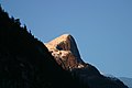
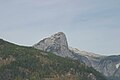
| One Eye Peak | |
|---|---|
 Old One Eye of Princess Louisa Inlet | |
| Highest point | |
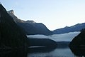
| Prominence | Princess Louise Inlet, East of Queens Reach, New Westminster Land District |
| Coordinates | 50°12′45.00″N123°49′1.00″W / 50.2125000°N 123.8169444°W |
| Geography | |
 One Eye Peak Location in British Columbia | |
 | |
| Interactive map of One Eye Peak | |
| Location | Princess Louisa Inlet , British Columbia, Canada |
| Parent range | Pacific Ranges |
| Topo map | NTS 92J4 Princess Louisa Inlet |
One Eye Peak is a mountain located at Princess Louisa Inlet. One Eye Peak is part of the Pacific Ranges of the Coast Mountains in southwestern British Columbia, Canada. When Thomas F. Hamilton build his resort called the Malibu Club at the entrance of Princess Louisa Inlet he named the mountain after himself - Mt. Hamilton. [1] The mountain is typically referred to by its English title of a Sechelt First Nation translation "TUHK-OHSS" referring to "Old One Eye" and is the protector of the inlet. [2]