
The Stikine River is a major river in northern British Columbia (BC), Canada and southeastern Alaska in the United States. It drains a large, remote upland area known as the Stikine Country east of the Coast Mountains. Flowing west and south for 610 kilometres (379 mi), it empties into various straits of the Inside Passage near Wrangell, Alaska. About 90 percent of the river's length and 95 percent of its drainage basin are in Canada. Considered one of the last truly wild large rivers in BC, the Stikine flows through a variety of landscapes including boreal forest, steep canyons and wide glacial valleys.
Telegraph Creek is a small community located off Highway 37 in northern British Columbia at the confluence of the Stikine River and Telegraph Creek. The only permanent settlement on the Stikine River, it is home to approximately 250 members of Tahltan First Nation and non-native residents. The town offers basic services, including Anglican and Catholic churches, a general store, a post office, a clinic with several nurses on-call around the clock, two Royal Canadian Mounted Police officers, and a K-9 school. Steep river banks and rocky gorges form the terraced nature of the geography.
Iskut is a small, mostly Indigenous community in the Stikine Country of northwestern British Columbia. It is located on Highway 37, at the north end of Eddontenajon Lake just south of Dease Lake and the crossing of the Stikine River.
The Skeena Mountains, also known as the Skeenas, are a subrange of the Interior Mountains of northern British Columbia, Canada, essentially flanking the upper basin of the Skeena River. They lie just inland from the southern end of the Boundary Ranges of the Coast Mountains, and also of the northern end of the Kitimat Ranges. Their southern limit is described by the Bulkley River and the upper northwestern reaches of Babine and Takla Lakes, and on their northeast by the upper reaches of the Omineca River.

The Stikine Country, also referred to as the Stikine District or simply "the Stikine", is one of the historical geographic regions of the Canadian province of British Columbia, located inland from the central Alaska Panhandle and comprising the basin of the Stikine River and its tributaries. The term Stikine–Iskut is also fairly common to describe the area, and references the Iskut River, the Stikine's largest tributary and describable as its south fork.

The Sacred Headwaters is a large subalpine drainage basin centred around Klappan Mountain of the Klappan Range in northern British Columbia. It is the source of three wild salmon rivers: the Skeena River, Nass River, and Stikine River. It is also referred to as the Klappan Valley, although the Klappan—a tributary of the Stikine River—is only one of the area's watersheds. Local Tahltan people call the area Klabona, which is loosely translated as "headwaters".

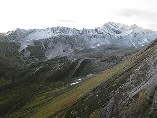
The Mount Edziza volcanic complex is a group of volcanoes and associated lava flows in northwestern British Columbia, Canada. Located on the Tahltan Highland, it is 40 kilometres southeast of Telegraph Creek and 85 kilometres southwest of Dease Lake. The complex encompasses a broad, steep-sided lava plateau that extends over 1,000 square kilometres. Its highest summit is 2,786 metres in elevation, making the MEVC the highest of four large complexes in an extensive north–south trending volcanic region. It is obscured by an ice cap characterized by several outlet glaciers that stretch out to lower altitudes.

The Stikine Plateau is a plateau in northern British Columbia, Canada. It lies between the Boundary Ranges of the Coast Mountains on the west and southwest and the Cassiar Mountains along its northeast, and between the Skeena Mountains on its south and southeast and the Jennings and Nakina Rivers on the north.
The Skeena Watershed Conservation Coalition is a non-governmental organization based in British Columbia which opposes Royal Dutch Shell's Klappan Coalbed Methane Project in a region dubbed the Sacred Headwaters by the Tahltan people, which is located in a mountainous area where the Klappan, Stikine, Skeena and Nass Rivers all have their origin. It was founded in 2004 by a diverse group of people living and working in the Skeena River watershed.
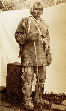
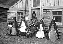
The Tàłtàn Nation is a tribal council-type organization combining the governments of two band governments of the Tahltan people in the Stikine Country of the Northern Interior of British Columbia, Canada. The two member governments are the Iskut First Nation and the Tahltan First Nation, which is also known as the Tahltan Indian Band. The Tahltan Nation is governed by the Tahltan Central Council, which is composed of representatives of 10 families from each band and has its offices at Dease Lake and Telegraph Creek.
The Klappan Coalbed Methane Project is a gas project owned by Shell Canada that looks to develop the coalbed methane from an area in northern British Columbia, near the source of three rivers: the Skeena River, Nass River, and Stikine River, and also the namesake Klappan River. The area is known in environmental politics and native lore as the Sacred Headwaters or Kablona. The project is the source of controversy and is opposed by First Nations groups and non-governmental organizations. If developed, the project will include a network of gas wells connected by roads and pipelines, as well as a pipeline to deliver the gas to market.

The Iskut River, located in the northwest part of the province of British Columbia is the largest tributary of the Stikine River, entering it about 11 km (6.8 mi) above its entry into Alaska.
The Klastline Plateau is a plateau in the Stikine Region of the Northern Interior of British Columbia, Canada. A subplateau of the Stikine Plateau, it is located between the Stikine River (N), the upper Iskut River (S), Mess Creek (W) and the Klappan River (E). The Skeena Mountains are to the south, the Tahltan Highland to the west, the Spatsizi Plateau to the east, and the Tanzilla Plateau to the north, on the other side of the Stikine. The Spatsizi and Tanzilla Plateaus, and the Tahltan Highland, are also part of the Stikine Plateau.
The Craig River is a transboundary river tributary of the Iskut River in Southeast Alaska, United States, and the northwest part of the province of British Columbia, Canada. Originating in Alaska, where it is sometimes called the South Fork Craig River, the Craig flows into British Columbia, generally in a northeast then northwest direction for about 50 km (31 mi) to join the Iskut River about 2 km (1.2 mi) east of the confluence of the Iskut and Hoodoo River. Its main tributary is the Jekill River.
The Klappan River is a major tributary of the Stikine River in northwestern British Columbia, Canada. It flows north from an area known as the Sacred Headwaters, which is the source not only of this river but also of the Nass, Skeena, Spatsizi and Stikine Rivers. The headwaters region is the site of a controversial coal-bed methane project.

The Bell-Irving River is a tributary of the Nass River in northwestern British Columbia, Canada. It originates in the Sacred Headwaters region, and flows about 165 km (103 mi) south to the Nass River. It course lies between the Oweegee Range of the Skeena Mountains to the east and the Boundary Ranges of the Coast Mountains to the west.
The Little Iskut River is a tributary of the Iskut River in the northwest part of the province of British Columbia, Canada, in Cassiar Land District. From its source at Little Ball Lake in Mount Edziza Provincial Park, the Little Iskut River flows about 45 km (28 mi), generally north to the vicinity of Mowdale Lake, then southeast and south to the Iskut River just below Cascade Falls. The Little Iskut River is part of the Stikine River drainage basin, as the Iskut River is a major tributary of the Stikine.
The Klastline River is a tributary of the Stikine River in northwestern British Columbia, Canada. It flows generally northwest about 70 km (43 mi) to join the Stikine River, which flows southwest across the Canada–United States border into Alaska where it empties into various straits of the Inside Passage. The Klastline River flows through Mount Edziza Provincial Park which lies within the traditional territory of the Tahltan people. Klastline means "confluence" or "junction of waters" in the Tahltan language.
Tsecha Creek is a tributary of Kakiddi Creek, which in turn is a tributary of the Klastline River, part of the Stikine River watershed in northwest part of the province of British Columbia, Canada. It flows generally west for about 16 km (9.9 mi) to join Kakiddi Creek about 5 km (3.1 mi) south of Kakiddi Creek's confluence with the Klastline River. Tsecha Creek's watershed covers 23.1 km2 (8.9 sq mi) and its mean annual discharge is estimated at 0.423 m3/s (14.9 cu ft/s). The mouth of Tsecha Creek is located about 44 km (27 mi) east-southeast of Telegraph Creek, about 26 km (16 mi) west of Iskut and about 73 km (45 mi) south-southwest of Dease Lake. Tsecha Creek's watershed's land cover is classified as 47.8% barren, 27.5% conifer forest, 13.1% shrubland, 10.3% snow/glacier, and small amounts of other cover.
Gerlib Creek is a tributary of Bourgeaux Creek and part of the Stikine River watershed in northwest part of the province of British Columbia, Canada. It flows generally east and south for roughly 10.5 km (6.5 mi) to join the Bourgeaux Creek, a tributary of the Little Iskut River, which in turn is a tributary of the Iskut River, the largest tributary of the Stikine River.

