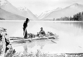
The Tahltan or Nahani are a First Nations people of the Athabaskan-speaking ethnolinguistic group who live in northern British Columbia around Telegraph Creek, Dease Lake, and Iskut. The Tahltan constitute the fourth division of the Nahane.
Telegraph Creek is a small community located off Highway 37 in northern British Columbia at the confluence of the Stikine River and Telegraph Creek. The only permanent settlement on the Stikine River, it is home to approximately 250 members of Tahltan First Nation and non-native residents. The town offers basic services, including Anglican and Catholic churches, a general store, a post office, a clinic with several nurses on-call around the clock, two Royal Canadian Mounted Police officers, and a K-9 school. Steep river banks and rocky gorges form the terraced nature of the geography.

The Musqueam Indian Band is a First Nations band government in the Canadian province of British Columbia. It is the only First Nations band whose reserve community lies within the boundaries of the City of Vancouver.
Iskut is a small, mostly Indigenous community in the Stikine Country of northwestern British Columbia. It is located on Highway 37, at the north end of Eddontenajon Lake just south of Dease Lake and the crossing of the Stikine River.

The Squamish Nation, Sḵwx̱wú7mesh Úxwumixw in Sḵwx̱wú7mesh Sníchim, is an Indian Act government originally imposed on the Squamish (Sḵwx̱wú7mesh) by the Federal Government of Canada in the late 19th century. The Squamish are Indigenous to British Columbia, Canada. Their band government comprises 8 elected councillors, serving four-year terms, with an elected band manager. Their main reserves are near the town of Squamish, British Columbia and around the mouths of the Capilano River, Mosquito Creek, and Seymour River on the north shore of Burrard Inlet in North Vancouver, British Columbia.

The Tahltan River is a tributary of the Stikine River in northwest part of the province of British Columbia, Canada. It flows generally east and southeast about 95 km (59 mi) to join the Stikine River at Tahltan, British Columbia. The lower Tahltan River marks the boundary between the Tahltan Highland and the Nahlin Plateau, both of which are part of the larger Stikine Plateau region.
The Tahltan First Nation, also known as the Tahltan Indian Band, is a band government of the Tahltan people. Their main community and reserves are located at Telegraph Creek, British Columbia. Their language is the Tahltan language, which is an Athabaskan language also known as Nahanni, is closely related to Kaska and Dunneza. Their Indian and Northern Affairs Canada band number is 682. The Tahltan First Nation is joined with the Iskut First Nation in a combined tribal council-type organization known as the Tahltan Nation.
The Tàłtàn Nation is a tribal council-type organization combining the governments of two band governments of the Tahltan people in the Stikine Country of the Northern Interior of British Columbia, Canada. The two member governments are the Iskut First Nation and the Tahltan First Nation, which is also known as the Tahltan Indian Band. The Tahltan Nation is governed by the Tahltan Central Council, which is composed of representatives of 10 families from each band and has its offices at Dease Lake and Telegraph Creek.

The Iskut River, located in the northwest part of the province of British Columbia is the largest tributary of the Stikine River, entering it about 11 km (6.8 mi) above its entry into Alaska.
The Hackett River is a tributary of the Sheslay River in northwest part of the province of British Columbia, Canada. It flows generally northwest about 33 km (21 mi), through two lakes, a wetland, and a gorge, to join the Sheslay River, which in turn is a tributary of the Inklin River, the main southeast fork of the Taku River.
The Tuya River is a major tributary of the Stikine River in northwest part of the province of British Columbia, Canada. From its source at High Tuya Lake in Tuya Mountains Provincial Park just south of Ash Mountain, the highest peak of the Tuya Range, the Tuya River flows south about 200 km (120 mi) to meet the Stikine River in the Grand Canyon of the Stikine. The Tuya River's main tributary is the Little Tuya River. The Tuya River divides the Tanzilla Plateau on the east from the Kawdy Plateau, to the northwest, and the Nahlin Plateau, to the southwest. All three are considered sub-plateaus of the Stikine Plateau. The Tuya River's watershed covers 3,575 km2 (1,380 sq mi), and its mean annual discharge is estimated at 36.9 m3/s (1,300 cu ft/s). The mouth of the Tuya River is located about 24 km (15 mi) northeast of Telegraph Creek, British Columbia, about 67 km (42 mi) southwest of Dease Lake, British Columbia, and about 210 km (130 mi) east of Juneau, Alaska. The Tuya River's watershed's land cover is classified as 35.7% shrubland, 31.4% conifer forest, 14.0% mixed forest, 7.2% herbaceous, and small amounts of other cover.
The Little Tuya River is a tributary of the Tuya River in northwest part of the province of British Columbia, Canada. It flows generally south and east about 71 km (44 mi) to join the Tuya River near Cariboo Meadows. The Little Tuya River's watershed covers 569 km2 (220 sq mi), and its mean annual discharge is an estimated 6.69 m3/s (236 cu ft/s).
The Leq'á:mel First Nation, formerly known as Lakahahmen First Nation, is a First Nations band government whose community and offices are located in the area near Deroche, British Columbia in the Fraser Valley region in Canada, about 12 kilometres east of the District of Mission. They are a member government of the Sto:lo Nation Chiefs Council, which is one of two tribal councils of the Sto:lo.
Tahltan is the name of a Northern Athabaskan people in northwestern British Columbia, and also the name of their language. It may also refer to:
Beatty Creek is a tributary of the Tahltan River in northwest part of the province of British Columbia, Canada. It flows generally south about 62 km (39 mi) to join the Tahltan River a few kilometres downstream from the Little Tahltan River confluence. The Tahltan River is one of the main tributaries of the Stikine River.
Bear Creek is a tributary of the Tahltan River in northwest part of the province of British Columbia, Canada. It flows generally south through the Nahlin Plateau about 28 km (17 mi) to join the Tahltan River just downstream from the Tahltan and Little Tahltan River confluence.
Classy Creek is a tributary of the Tuya River in northwest part of the province of British Columbia, Canada. It flows generally southeast and south roughly 20 km (12 mi) to join the Tuya River about 10 km (6.2 mi) north of the Tuya River's confluence with the Stikine River in the Grand Canyon of the Stikine, near Telegraph Creek Road, unofficially called Highway 51, a spur of the Stewart–Cassiar Highway.
Hartz Creek is a tributary of the Tahltan River, part of the Stikine River watershed in northwest part of the province of British Columbia, Canada. It flows generally south and southwest for roughly 14 km (8.7 mi) to join the Tahltan River about 4.5 km (2.8 mi) north of Tahltan, British Columbia at the Tahltan River's confluence with the Stikine River. Hartz Creek's watershed covers 39.1 km2 (15.1 sq mi), and its mean annual discharge is estimated at 0.315 m3/s (11.1 cu ft/s). The mouth of Hartz Creek is located about 18 km (11 mi) northeast of Telegraph Creek, British Columbia, about 73 km (45 mi) southwest of Dease Lake, British Columbia, and about 200 km (120 mi) east of Juneau, Alaska. Hartz Creek's watershed's land cover is classified as 44.2% shrubland, 30.7% mixed forest, 20.8% conifer forest, and small amounts of other cover.
Middle Creek is a tributary of the Tahltan River, part of the Stikine River watershed in northwest part of the province of British Columbia, Canada. It flows generally south for roughly 15 km (9.3 mi) to join the Tahltan River about 10 km (6.2 mi) north of Tahltan, British Columbia at the Tahltan River's confluence with the Stikine River. Middle Creek's watershed covers 49.6 km2 (19.2 sq mi), and its mean annual discharge is estimated at 0.449 m3/s (15.9 cu ft/s). The mouth of Middle Creek is located about 20 km (12 mi) north of Telegraph Creek, British Columbia, about 75 km (47 mi) southwest of Dease Lake, British Columbia, and about 197 km (122 mi) east of Juneau, Alaska. Middle Creek's watershed's land cover is classified as 45.2% shrubland, 30.8% conifer forest, 21.4% mixed forest, and small amounts of other cover.
Riley Creek is a tributary of Middle Creek, which in turn is a tributary of the Tahltan River, part of the Stikine River watershed in northwest part of the province of British Columbia, Canada. It flows generally south for roughly 10 km (6.2 mi) to join Middle Creek about 1.5 km (0.93 mi) north of Middle Creek's confluence with the Tahltan River. Riley Creek's watershed covers 22.1 km2 (8.5 sq mi), and its mean annual discharge is estimated at 0.192 m3/s (6.8 cu ft/s). The mouth of Riley Creek is located about 22 km (14 mi) north of Telegraph Creek, British Columbia, about 74 km (46 mi) southwest of Dease Lake, British Columbia, and about 122 km (76 mi) east of Juneau, Alaska. Riley Creek's watershed's land cover is classified as 39.9% shrubland, 36.8% conifer forest, 20.3% mixed forest, and small amounts of other cover.
