Related Research Articles

The Chilcotin Group, also called the Chilcotin Plateau Basalts, is a large area of basaltic lava that forms a volcanic plateau running parallel with the Garibaldi Volcanic Belt in south-central British Columbia, Canada.

The Northern Cordilleran Volcanic Province (NCVP), formerly known as the Stikine Volcanic Belt, is a geologic province defined by the occurrence of Miocene to Holocene volcanoes in the Pacific Northwest of North America. This belt of volcanoes extends roughly north-northwest from northwestern British Columbia and the Alaska Panhandle through Yukon to the Southeast Fairbanks Census Area of far eastern Alaska, in a corridor hundreds of kilometres wide. It is the most recently defined volcanic province in the Western Cordillera. It has formed due to extensional cracking of the North American continent—similar to other on-land extensional volcanic zones, including the Basin and Range Province and the East African Rift. Although taking its name from the Western Cordillera, this term is a geologic grouping rather than a geographic one. The southmost part of the NCVP has more, and larger, volcanoes than does the rest of the NCVP; further north it is less clearly delineated, describing a large arch that sways westward through central Yukon.

Hoodoo Mountain is a potentially active flat-topped stratovolcano in the Stikine Country of northwestern British Columbia, Canada, located 74 km (46 mi) northeast of Wrangell, Alaska, on the north side of the lower Iskut River and 30 km (19 mi) east of its junction with the Stikine River. It is situated in the Boundary Ranges of the Coast Mountains and existed since the Late Pleistocene stage of the Pleistocene epoch, which began 130,000 years ago and ended 10,000 years ago.
Lava Fork is a creek in northwestern British Columbia, Canada and of the Alaska Panhandle, United States. It lies west of the Unuk River and northwest of Stewart. It flows south from the Lava Lakes across the British Columbia-Alaska border into the Blue River in the extreme northern part of Misty Fjords National Monument.

Heart Peaks, originally known as the Heart Mountains, is a mountain massif in the Northern Interior of British Columbia, Canada. It is 90 km (56 mi) northwest of the small community of Telegraph Creek and just southwest of Callison Ranch. With a maximum elevation of 2,012 m (6,601 ft), it rises above the surrounding landscape on the Nahlin Plateau, which is part of the western Stikine Plateau. Heart Peaks has been an area of prospecting since the 1980s with the discovery of precious metals.

The Atlin Volcanic Field, also called the Llangorse Volcanic Field and the Surprise Lake Volcanic Field, is a group of late-Pleistocene to Holocene cinder cones that lies on the Teslin Plateau east of Atlin Lake, Canada. The largest volcanic feature is the 1880-m-high Ruby Mountain which has been partially dissected by Pleistocene and post-Wisconsin glaciation. Two basaltic cinder cones at the heads of Cracker Creek and Volcanic Creek lie within glacially dissected U-shaped valleys and may be of postglacial age.
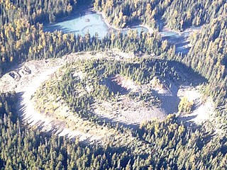
Volcanic Creek Cone is a small cinder cone 20 kilometres northeast of Atlin in northwestern British Columbia. There are two cinder cones and a lava flow at least 3 kilometres long which is present below parts of the tree covered area. The subdued form of Volcanic Creek cone is visible directly below the largest snow patch. The cone has probably suffered through at least one glacial episode. Volcanic Creek cone is part of the Northern Cordilleran Volcanic Province.
The Tseax Cone, also called the Tseax River Cone or the Aiyansh Volcano, is a young and active cinder cone and adjacent lava flows associated with the Nass Ranges and the Northern Cordilleran Volcanic Province. It is located east of Crater Creek at outlet of Melita Lake, southeast of Gitlakdamix and 60 kilometres (37 mi) north of Terrace, British Columbia, Canada.

Level Mountain is a massive complex volcano in the Northern Interior of British Columbia, Canada. It is located 50 km (31 mi) north–northwest of Telegraph Creek and 60 km (37 mi) west of Dease Lake on the Nahlin Plateau. With a maximum elevation of 2,164 m (7,100 ft), it is the third highest of five large complexes in an extensive north–south trending volcanic zone. Much of the mountain is gently-sloping; when measured from its base, Level Mountain is about 1,100 m (3,600 ft) tall, slightly taller than its neighbour to the northwest, Heart Peaks. The lower, broader half of Level Mountain consists of a shield-like edifice while its upper half has a more steep, jagged profile. Its large summit is dominated by the Level Mountain Range, a small mountain range with prominent peaks cut by deep valleys. These valleys serve as a radial drainage for several small streams that flow from the volcano. Meszah Peak is the only named peak in the Level Mountain Range.
Toozaza Peak is a tuya in the Stikine Ranges of the Cassiar Mountains in northern British Columbia, Canada, located in the Iverson Creek. Toozaza Peak is the summit of a north–south aligned ridge between the head of Toozaza Creek and the head of the Jennings River, just south of the Jennings' divide with the Little Rancheria River headwaters. The Little Rancheria and Toozaza Creek are part of the Liard, while the Jennings is part of the Yukon River drainage via Teslin Lake, and the peak therefore stands astride the line of the Continental Divide. It is part of the Tuya Volcanic Field, a volcanic field associated with the Stikine Volcanic Belt, part of the Northern Cordilleran Volcanic Province.

The geology of the Pacific Northwest includes the composition, structure, physical properties and the processes that shape the Pacific Northwest region of North America. The region is part of the Ring of Fire: the subduction of the Pacific and Farallon Plates under the North American Plate is responsible for many of the area's scenic features as well as some of its hazards, such as volcanoes, earthquakes, and landslides.

The Stikine Country, also referred to as the Stikine District or simply "the Stikine", is one of the historical geographic regions of the Canadian province of British Columbia, located inland from the central Alaska Panhandle and comprising the basin of the Stikine River and its tributaries. The term Stikine–Iskut is also fairly common to describe the area, and references the Iskut River, the Stikine's largest tributary and describable as its south fork.
Armadillo Peak is a 7.5-million-year-old caldera, located about 3 km north of Bourgeaux Creek and northeast of Raspberry Pass, British Columbia, Canada. It is south of Mount Edziza and is overlapped by the Ice Peak central volcano, which was formed during the early Pleistocene. Its caldera is largely destroyed by glaciers. It is part of the Mount Edziza volcanic complex, which is made of basaltic lava flows.
Maitland Volcano is a heavily eroded shield volcano in the Northern Interior of British Columbia, Canada. It is 83 km (52 mi) southeast of the small community of Telegraph Creek in what is now the Klappan Range of the northern Skeena Mountains. This multi-vent volcano covered a remarkably large area and was topped by a younger volcanic edifice. Little remains of Maitland Volcano today, limited only to eroded lava flows and distinctive upstanding landforms created when magma hardened within the vents of the volcano.
The Mount Edziza volcanic complex is a large and potentially active north-south trending complex volcano in Stikine Country, northwestern British Columbia, Canada, located 38 kilometres (24 mi) southeast of the small community of Telegraph Creek. It occupies the southeastern portion of the Tahltan Highland, an upland area of plateau and lower mountain ranges, lying east of the Boundary Ranges and south of the Inklin River, which is the east fork of the Taku River. As a volcanic complex, it consists of many types of volcanoes, including shield volcanoes, calderas, lava domes, stratovolcanoes, and cinder cones.

The Volcano, also known as Lava Fork volcano, is a small cinder cone in the Boundary Ranges of the Coast Mountains in northwestern British Columbia, Canada. It is located approximately 60 km (40 mi) northwest of the small community of Stewart near the head of Lava Fork. With a summit elevation of 1,656 m (5,433 ft) and a topographic prominence of 311 m (1,020 ft), it rises above the surrounding rugged landscape on a remote mountain ridge that represents the northern flank of a glaciated U-shaped valley.

The volcanic history of the Northern Cordilleran Volcanic Province presents a record of volcanic activity in northwestern British Columbia, central Yukon and the U.S. state of easternmost Alaska. The volcanic activity lies in the northern part of the Western Cordillera of the Pacific Northwest region of North America. Extensional cracking of the North American Plate in this part of North America has existed for millions of years. Continuation of this continental rifting has fed scores of volcanoes throughout the Northern Cordilleran Volcanic Province over at least the past 20 million years and occasionally continued into geologically recent times.

The Canadian Cascade Arc, also called the Canadian Cascades, is the Canadian segment of the North American Cascade Volcanic Arc. Located entirely within the Canadian province of British Columbia, it extends from the Cascade Mountains in the south to the Coast Mountains in the north. Specifically, the southern end of the Canadian Cascades begin at the Canada–United States border. However, the specific boundaries of the northern end are not precisely known and the geology in this part of the volcanic arc is poorly understood. It is widely accepted by geologists that the Canadian Cascade Arc extends through the Pacific Ranges of the Coast Mountains. However, others have expressed concern that the volcanic arc possibly extends further north into the Kitimat Ranges, another subdivision of the Coast Mountains, and even as far north as Haida Gwaii.

The Bell-Irving River is a tributary of the Nass River in northwestern British Columbia, Canada. It originates in the Sacred Headwaters region, and flows about 165 km (103 mi) south to the Nass River. It course lies between the Oweegee Range of the Skeena Mountains to the east and the Boundary Ranges of the Coast Mountains to the west.
References
- 1 2 Edwards, B. R.; Evenchick, C. A.; McNicoll, V. J.; Wetherell, K.; Nogier, M. (2006). Overview of the volcanology of the Bell-Irving volcanic district, northwestern British Columbia: new examples of mafic alpine glaciovolcanism from the northern Cordilleran volcanic province. Natural Resources Canada. pp. 1–9. ISBN 978-0-662-42826-8.