Related Research Articles

The Northern Cordilleran Volcanic Province (NCVP), formerly known as the Stikine Volcanic Belt, is a geologic province defined by the occurrence of Miocene to Holocene volcanoes in the Pacific Northwest of North America. This belt of volcanoes extends roughly north-northwest from northwestern British Columbia and the Alaska Panhandle through Yukon to the Southeast Fairbanks Census Area of far eastern Alaska, in a corridor hundreds of kilometres wide. It is the most recently defined volcanic province in the Western Cordillera. It has formed due to extensional cracking of the North American continent—similar to other on-land extensional volcanic zones, including the Basin and Range Province and the East African Rift. Although taking its name from the Western Cordillera, this term is a geologic grouping rather than a geographic one. The southmost part of the NCVP has more, and larger, volcanoes than does the rest of the NCVP; further north it is less clearly delineated, describing a large arch that sways westward through central Yukon.
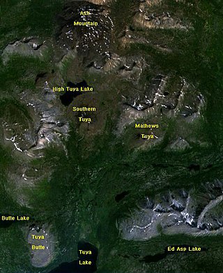
The Tuya volcanic field is a volcanic field of tuyas located in far northern British Columbia, Canada, near the border with the Yukon Territory and focused on the area of the Tuya Range, a subrange of the Stikine Ranges of the Cassiar Mountains, though some vents are in the Kawdy Plateau, the northernmost part of the Stikine Plateau. Several small shield volcanoes, and postglacial lapilli cones and lava flows have been reported in this area. The only nonglacial volcanoes in the field are Gabrielse Cone and the West Tuya lava field.
Tuya Butte is a tuya in the Tuya Range of north-central British Columbia, Canada. It is a bit less isolated from other ranges than neighbouring Mount Josephine. Some of the other volcanoes in the area include South Tuya, Ash Mountain, and Mathews Tuya.

The Alligator Lake volcanic complex is a group of basaltic cinder cones and lava flows in south central Yukon. The upper part of the Alligator Lake volcanic complex consists of two well-preserved cinder cones capping a small shield volcano. They probably post-date the local Holocene glaciation. Lava flows from both cinder cones traveled to the north and were erupted simultaneously. Their compositions range from alkali olivine basalt to basanitic. Lava flows from the northeast cone are the largest extending 6 km (4 mi) from the cone and expanding to a width of 10 km (6 mi) at the terminus.
The Atlin Volcanic Field, also called the Llangorse Volcanic Field and the Surprise Lake Volcanic Field, is a group of late-Pleistocene to Holocene cinder cones that lies on the Teslin Plateau east of Atlin Lake, Canada. The largest volcanic feature is the 1880-m-high Ruby Mountain which has been partially dissected by Pleistocene and post-Wisconsin glaciation. Two basaltic cinder cones at the heads of Cracker Creek and Volcanic Creek lie within glacially dissected U-shaped valleys and may be of postglacial age.
Cracker Creek Cone is a small cinder cone in northwestern British Columbia. A large lava flow that partly filled Ruby Creek may have originated from this cone. The lower west side of the cone appears to be partly covered by glacial till suggesting that the cone is older than the most recent glacial advances down Ruby Creek. Cracker Creek Cone is in the Northern Cordilleran Volcanic Province and is one of the three young volcanic cones in the Atlin Volcanic Field.

Volcano Mountain is a cinder cone in central Yukon Territory, Canada, located a short distance north of Fort Selkirk, near the confluence of the Pelly and Yukon Rivers. Volcano Mountain is called Nelrúna in the Northern Tutchone language.
The Desolation Lava Field is a volcanic field associated with the Mount Edziza volcanic complex in British Columbia, Canada. It covers 150 km2 (58 sq mi) on the northern end of the Mount Edziza volcanic complex and is the largest area of the youngest lava flows. The longest lava flow from the field and the volcanic complex, is about 12 km (7.5 mi) long. Eve Cone, in the middle of the field, is one of the most symmetrical and best preserved cinder cones in Canada.
Sidas Cone is a cinder cone on the Big Raven Plateau at the northern end of Mount Edziza Provincial Park in British Columbia, Canada. Its name, meaning "cut oneself with a knife" in the Tahltan language, is descriptive of the breach that has cut the cone into two symmetrical halves.
Toozaza Peak is a tuya in the Stikine Ranges of the Cassiar Mountains in northern British Columbia, Canada, located in the Iverson Creek. Toozaza Peak is the summit of a north–south aligned ridge between the head of Toozaza Creek and the head of the Jennings River, just south of the Jennings' divide with the Little Rancheria River headwaters. The Little Rancheria and Toozaza Creek are part of the Liard, while the Jennings is part of the Yukon River drainage via Teslin Lake, and the peak therefore stands astride the line of the Continental Divide. It is part of the Tuya Volcanic Field, a volcanic field associated with the Stikine Volcanic Belt, part of the Northern Cordilleran Volcanic Province.
Ibex Mountain is a young cinder cone in the Yukon Territory, Canada, located 33 km southwest of Whitehorse and 12 km southeast of Mount Arkell. It is in a group of basaltic cones and lava flows called Alligator Lake and is in the Northern Cordilleran Volcanic Province. It is believed Ibex Mountain last erupted during the Pleistocene. Ibex Mountain is at the head of the Ibex River, which is southeast of Whitehorse. There is a road that runs close to Ibex Lake on the southeast side of the summit. From there is the hike to the summit of the cone.
Prindle Volcano is an isolated basaltic cinder cone located in eastern Alaska, United States, in the headwaters of the East Fork of the Fortymile River, approximately 80 kilometers northeast of Tok, Alaska. The cone is fresh-looking and has a base approximately 900 metres wide. It is the northwesternmost expression of the Northern Cordilleran Volcanic Province. The cinder cone, and an approximately 11-kilometre (6.8-mile) long lava flow which breached the margin of the cone, erupted in the Pleistocene approximately 176,000 years ago. The lava flow extends to the southeast, then turns southwest and continues in a river valley.
Ne Ch'e Ddhäwa is the Northern Tutchone name for an eroded tuya approximately 7 km up the Yukon River from Fort Selkirk in the Fort Selkirk Volcanic Field of central Yukon, Canada. It has been described as a cinder cone or a subglacial mound. The volcano erupted subglacially between 2.0 and 2.3 million years ago during the early Pleistocene, erupting hyaloclastite tuffs, breccias, and pillow breccias. These hyaloclastites locally contain exotic clasts and bodies of till melted from an ice sheet during the subglacial eruption.
Outcast Hill is an isolated hill in northern British Columbia, Canada, located southeast of Mess Lake. It lies at the southern end of Mount Edziza Provincial Park.

The Snowshoe Lava Field is a volcanic field associated with the Mount Edziza volcanic complex in northern British Columbia, Canada. It is on the southern end of the Big Raven Plateau and is an area of young lava flows.
Exile Hill is an isolated hill in the Spectrum Range of northern British Columbia, Canada, located southeast of Mess Lake. It lies at the southern end of Mount Edziza Provincial Park.
Fort Selkirk Vent is a geological name for a cinder cone in central Yukon, Canada, located just east of Fort Selkirk along the Yukon River.
Mess Lake Cone is a cinder cone in northwestern British Columbia, Canada. It is polygenetic in nature, having erupted more than once throughout its eruptive history. Mess Lake Cone is one of the volcanoes that produced young basaltic lava flows in the central portion of the Mount Edziza volcanic complex in the past 10,000 years. These basaltic lava flows form a north–south trending volcanic field called the Mess Lake Lava Field.

The volcanic history of the Northern Cordilleran Volcanic Province presents a record of volcanic activity in northwestern British Columbia, central Yukon and the U.S. state of easternmost Alaska. The volcanic activity lies in the northern part of the Western Cordillera of the Pacific Northwest region of North America. Extensional cracking of the North American Plate in this part of North America has existed for millions of years. Continuation of this continental rifting has fed scores of volcanoes throughout the Northern Cordilleran Volcanic Province over at least the past 20 million years and occasionally continued into geologically recent times.
References
| | This article about a Yukon location is a stub. You can help Wikipedia by expanding it. |