Cowichan Valley Regional District

Last updated

Cowichan Valley
Cowichan Valley Regional District
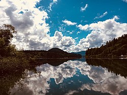
Lake Cowichan.jpg
Cowichan Valley BC logo.png
CAN BC Cowichan Valley Regional District locator.svg
Location in British Columbia
CountryCanada
Province British Columbia
Administrative office location Duncan
Government
[1]
  TypeRegional district
  BodyBoard of directors
  ChairIan Morrison (F)
  Vice chairSierra Acton (B)
  Electoral areas
  • A – Mill Bay/Malahat
  • B – Shawnigan Lake
  • C – Cobble Hill
  • D – Cowichan Bay
  • E – Cowichan Station/Sahtlam/Glenora
  • F – Cowichan Lake South/Skutz Falls
  • G – Saltair/Gulf Islands
  • H – North Oyster/Diamond
  • I – Youbou/Meade Creek
Area
  Land3,474.52 km2 (1,341.52 sq mi)
Population
 (2021) [2]
  Total89,013
  Density25.6/km2 (66/sq mi)
Website www.cvrd.ca OOjs UI icon edit-ltr-progressive.svg

The Cowichan Valley Regional District is a regional district in the Canadian province of British Columbia that is on the southern part of Vancouver Island, [3] bordered by the Nanaimo and Alberni-Clayoquot Regional Districts to the north and northwest, and by the Capital Regional District to the south and east. As of the 2021 Census, the Regional District had a population of 89,013. The regional district offices are in Duncan.

Contents

Geography

The Cowichan Valley Regional District covers an area between the Stuart Channel and Saanich Inlet on the east coast of Vancouver Island and the southern part of the West Coast Trail, with Cowichan Lake and Cowichan Valley proper located in its central region. It includes the Gulf Islands of Thetis, Penelakut and Valdes. The total land area is 3,473.12 km² (1,340.98 sq mi).

Communities

Incorporated communities

Indigenous Reserves

Electoral areas

A

B

C

D

E

F

G

H

I

Demographics

As a census division in the 2021 Census of Population conducted by Statistics Canada, the Cowichan Valley Regional District had a population of 89,013 living in 37,290 of its 40,174 total private dwellings, a change of

Panethnic groups in the Cowichan Valley Regional District (1986–2021)
Panethnic
group
2021 [5] 2016 [6] 2011 [7] 2006 [8] 2001 [9] 1996 [10] 1991 [11] [12] 1986 [13] [14] [15] :104
Pop. %Pop.%Pop.%Pop.%Pop.%Pop.%Pop.%Pop.%
European [lower-alpha 1] 71,46068,41566,97565,87562,27562,44552,95546,080
Indigenous 10,9859,6608,5257,4206,2605,6555,1104,025
South Asian 1,2951,2601,1501,4401,3601,2351,1551,380
East Asian [lower-alpha 2] 1,2801,025880765665655405350
Southeast Asian [lower-alpha 3] 90571565552030019017555
African 63030518516021519014065
Latin American 2651501009565303035
Middle Eastern [lower-alpha 4] 1401303575757014535
Other [lower-alpha 5] 3752251601309550
Total responses87,33081,88578,67576,47571,31570,52560,11552,025
Total population89,01383,73980,33276,92971,99870,97860,56052,466

Notes

  1. Statistic includes all persons that did not make up part of a visible minority or an indigenous identity.
  2. Statistic includes total responses of "Chinese", "Korean", and "Japanese" under visible minority section on census.
  3. Statistic includes total responses of "Filipino" and "Southeast Asian" under visible minority section on census.
  4. Statistic includes total responses of "West Asian" and "Arab" under visible minority section on census.
  5. Statistic includes total responses of "Visible minority, n.i.e." and "Multiple visible minorities" under visible minority section on census.

Related Research Articles

<span class="mw-page-title-main">Alberni-Clayoquot Regional District</span> Regional district in British Columbia, Canada

The Alberni–Clayoquot Regional District of British Columbia is located on west central Vancouver Island. Adjacent regional districts it shares borders with are the Strathcona and Comox Valley Regional Districts to the north, and the Nanaimo and Cowichan Valley Regional Districts to the east. The regional district offices are located in Port Alberni.

<span class="mw-page-title-main">Regional District of Kootenay Boundary</span> Regional district in British Columbia, Canada

The Regional District of Kootenay Boundary (RDKB) is one of 28 regional districts in the province of British Columbia, Canada. As of the 2016 Canadian census, the population was 31,447. The area is 8,095.62 km2. The RDKB was incorporated in 1966 and consists of eight incorporated municipalities and five unincorporated electoral areas. The regional district's offices are in the City of Trail, with secondary offices in the City of Grand Forks. Other major population centres include the cities of Rossland and Greenwood, and the villages of Fruitvale, Warfield, and Montrose. The region also encompasses electoral areas A, B/Lower Columbia-Old Glory, C/Christina Lake, D/Rural Grand Forks and E/West Boundary including Rock Creek, Bridesville, Beaverdell and Big White Ski Resort.

<span class="mw-page-title-main">Sparwood</span> District municipality in British Columbia, Canada

Sparwood is a district municipality in the Canadian province of British Columbia. It is the second-largest community on the Elk River.

<span class="mw-page-title-main">Squamish-Lillooet Regional District</span> Regional district in British Columbia, Canada

The Squamish-Lillooet Regional District is a quasi-municipal administrative area in British Columbia, Canada. It stretches from Britannia Beach in the south to Pavilion in the north. Lillooet, Pemberton, Whistler and Squamish are the four municipalities in the regional district. Its administrative offices are in the Village of Pemberton, although the district municipalities of Squamish and Whistler are larger population centres. The district covers 16,353.68 km² of land area.

qathet Regional District Regional district in British Columbia, Canada

The qathet Regional District is a regional district in the Canadian province of British Columbia. Its only incorporated municipality is the City of Powell River, although it includes a number of unincorporated areas. The district encompasses a land area of 5,075.33 square kilometres (1,959.60 sq mi). The district was formerly known as the Powell River Regional District. Because of frequent confusion between the identical names of Powell River district and city, the district's name was changed in 2018 to qathet, from q̓at̓ᶿət, meaning "working together, bringing together" in the Comox language of the Tla'amin Nation.

<span class="mw-page-title-main">Duncan, British Columbia</span> City in British Columbia, Canada

Duncan is a city on southern Vancouver Island in British Columbia, Canada. It is the smallest city by area in Canada. It was incorporated in 1912.

<span class="mw-page-title-main">Thompson-Nicola Regional District</span> Regional district in British Columbia, Canada

The Thompson–Nicola Regional District is a regional district in the Canadian province of British Columbia. The Canada 2021 Census population was 143,680 and the area covers 44,449.49 square kilometres. The administrative offices are in the main population centre of Kamloops, which accounts for 78 percent of the regional district's population. The only other city is Merritt; other municipally-incorporated communities include the District Municipalities of Logan Lake, Barriere and Clearwater and the Villages of Chase, Ashcroft, Cache Creek, Clinton and Lytton, and also the Mountain Resort Municipality of Sun Peaks.

<span class="mw-page-title-main">Regional District of East Kootenay</span> Regional district in British Columbia, Canada

The Regional District of East Kootenay (RDEK) is a regional district in the Canadian province of British Columbia, Canada. In the 2016 census, the population was 60,439. Its area is 27,542.69 km2 (10,634.29 sq mi). The regional district offices are in Cranbrook, the largest community in the region. Other important population centres include the cities of Kimberley and Fernie, and the district municipality of Invermere and Sparwood. Despite its name, the regional district does not include all of the region known as the East Kootenay, which includes the Creston Valley and the east shore of Kootenay Lake.

<span class="mw-page-title-main">Regional District of Central Kootenay</span> Regional district in British Columbia, Canada

The Regional District of Central Kootenay (RDCK) is a regional district in the province of British Columbia, Canada. As of the 2016 census, the population was 59,517. The area is 22,130.72 square kilometres. The administrative centre is located in the city of Nelson. Other municipalities include the City of Castlegar, the Town of Creston, the Village of Salmo, the Village of Nakusp, the Village of Kaslo, the Village of New Denver, the Village of Silverton, the Village of Ymir and the Village of Slocan.

<span class="mw-page-title-main">Regional District of Bulkley-Nechako</span> Regional district in British Columbia, Canada

The Regional District of Bulkley–Nechako (RDBN) is a regional district in the Canadian province of British Columbia, Canada. As of the 2021 census, the population was 37,737. The area is 73,419.01 square kilometres. The regional district offices are in Burns Lake.

<span class="mw-page-title-main">Regional District of Central Okanagan</span> Regional district in British Columbia, Canada

The Regional District of Central Okanagan (RDCO) is a regional district in the Canadian province of British Columbia, representing two unincorporated Electoral Areas of Central Okanagan East and Central Okanagan West, along with the member municipalities of the City of Kelowna, City of West Kelowna, the District of Lake Country, the District of Peachland, and Westbank First Nation. The RDCO office is located in Kelowna.

<span class="mw-page-title-main">Municipality of the District of Lunenburg</span> District municipality in Nova Scotia, Canada

The Municipality of the District of Lunenburg, is a district municipality in Lunenburg County, Nova Scotia, Canada. Statistics Canada classifies the district municipality as a municipal district.

<span class="mw-page-title-main">North Cowichan</span> District municipality in British Columbia, Canada

North Cowichan is a district municipality established in 1873 on Vancouver Island, in British Columbia, Canada. The municipality is part of the Cowichan Valley Regional District. North Cowichan is noted for a landscape including forests, beaches, rivers, and lakes. The municipality encompasses the communities of Chemainus; Westholme; Crofton; Maple Bay; and "the South End". The latter is an informal name for a built-up area which is essentially a suburb of the City of Duncan, a separate municipality.

<span class="mw-page-title-main">Vanderhoof, British Columbia</span> District municipality in British Columbia, Canada

Vanderhoof is a district municipality near the geographical centre of British Columbia, Canada. Covering 2.92 square kilometers, it has a population of about 4,500 within town limits, and offers services to nearly 10,000 people in nearby rural communities. Its main industries are forestry, agriculture, and related businesses. Tourism is also growing, and mining operations are being developed in the area. It has many elementary schools, and one major secondary school, Nechako Valley Secondary School (NVSS), comprising School District 91 Nechako Lakes. The College of New Caledonia has a regional campus there.

<span class="mw-page-title-main">Regional District of North Okanagan</span> Regional district in British Columbia, Canada

The Regional District of North Okanagan (RDNO) is a regional district in the Canadian province of British Columbia, Canada. The Canada 2011 Census population was 81,237. The land area is 7,512.58 km². The regional district's head office is in the district municipality of Coldstream, although the largest population centre is its immediate neighbour, the city of Vernon.

<span class="mw-page-title-main">Regional District of Fraser–Fort George</span> Regional district in British Columbia, Canada

The Regional District of Fraser–Fort George (RDFFG) is a regional district located in the Central Interior of British Columbia, Canada. It is bounded by the Alberta border to the east, the Columbia–Shuswap and Thompson–Nicola regional districts to the south and southeast, Cariboo Regional District to the southwest, the Regional District of Bulkley–Nechako to the west, and the Peace River Regional District to the north and northeast. As of the Canada 2011 Census, Fraser–Fort George had a population of 91,879 and a land area of 51,083.73 km2. The offices of the regional district are located at Prince George.

The demographics of Metro Vancouver indicate a multicultural and multiracial region. Metro Vancouver is a metropolitan area, with its major urban centre being Vancouver, British Columbia, Canada. The Vancouver census metropolitan area, as defined by Statistics Canada, encompasses roughly the same territory as the Metro Vancouver Regional District, a regional district in British Columbia. The regional district includes 23 local authorities. Figures provided here are for the Vancouver census metropolitan area and not for the City of Vancouver.

Lake Cowichan is a town located on the east end of Cowichan Lake and, by highway, is 27 kilometres (17 mi) west of Duncan, British Columbia. The town of Lake Cowichan was incorporated in 1944. The Cowichan River flows through the middle of the town. Cowichan River is designated as a Heritage River.

According to the 2021 census, the City of Edmonton had a population of 1,010,899 residents, compared to 4,262,635 for all of Alberta, Canada. The total population of the Edmonton census metropolitan area (CMA) was 1,418,118, making it the sixth-largest CMA in Canada.

<span class="mw-page-title-main">Cowichan—Malahat—Langford</span> Federal electoral district in British Columbia, Canada

Cowichan—Malahat—Langford is a federal electoral district in British Columbia, Canada. It is on south-central Vancouver Island. It encompasses a portion of British Columbia previously included in the electoral districts of Nanaimo—Cowichan and Esquimalt—Juan de Fuca.

References

  1. "Board of Directors" . Retrieved July 9, 2019.
  2. "Cowichan Valley Regional District". BC Geographical Names .
  3. "Population and dwelling counts: Canada and census divisions". Statistics Canada. February 9, 2022. Retrieved April 3, 2022.
  4. Government of Canada, Statistics Canada (October 26, 2022). "Census Profile, 2021 Census of Population". www12.statcan.gc.ca. Retrieved February 20, 2023.
  5. Government of Canada, Statistics Canada (October 27, 2021). "Census Profile, 2016 Census". www12.statcan.gc.ca. Retrieved February 20, 2023.
  6. Government of Canada, Statistics Canada (November 27, 2015). "NHS Profile". www12.statcan.gc.ca. Retrieved February 20, 2023.
  7. Government of Canada, Statistics Canada (August 20, 2019). "2006 Community Profiles". www12.statcan.gc.ca. Retrieved February 20, 2023.
  8. Government of Canada, Statistics Canada (July 2, 2019). "2001 Community Profiles". www12.statcan.gc.ca. Retrieved February 20, 2023.
  9. Government of Canada, Statistics Canada (June 4, 2019). "Electronic Area Profiles Profile of Census Divisions and Subdivisions, 1996 Census". www12.statcan.gc.ca. Retrieved February 20, 2023.
  10. Government of Canada, Statistics Canada (March 29, 2019). "1991 Census Area Profiles Profile of Census Divisions and Subdivisions – Part B". www12.statcan.gc.ca. Retrieved February 20, 2023.
  11. Government of Canada, Statistics Canada (March 29, 2019). "Data tables, 1991 Census Population by Ethnic Origin (24), Showing Single and Multiple Origins (2) – Canada, provinces and territories, census divisions and census subdivisions". www12.statcan.gc.ca. Retrieved February 20, 2023.
  12. Government of Canada, Statistics Canada (June 27, 2019). "Data tables, 1986 Census Census Profile for Canada, Provinces and Territories, Census Divisions and Census Subdivisions, 1986 Census – Part A". www12.statcan.gc.ca. Retrieved February 20, 2023.
  13. Government of Canada, Statistics Canada (June 27, 2019). "Data tables, 1986 Census Census Profile for Canada, Provinces and Territories, Census Divisions and Census Subdivisions, 1986 Census – Part B". www12.statcan.gc.ca. Retrieved February 20, 2023.
  14. Government of Canada, Statistics Canada (April 3, 2013). "Canada's aboriginal population by census subdivisions from the 1986 Census of Canada". www12.statcan.gc.ca. Retrieved February 20, 2023.