
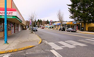
Chemainus is a community in the Chemainus Valley on the east coast of southern Vancouver Island, British Columbia, Canada.

The Regional District of Nanaimo is a regional district located on the eastern coast of Vancouver Island, British Columbia, Canada. It is bordered to the south by the Cowichan Valley Regional District, to the west by the Alberni-Clayoquot Regional District, and to the northwest by the Comox Valley Regional District. Its administration offices are located in Nanaimo. During the 2016 census, its population was established at 155,698.

The Cowichan Valley Regional District is a regional district in the Canadian province of British Columbia is on the southern part of Vancouver Island, bordered by the Nanaimo and Alberni-Clayoquot Regional Districts to the north and northwest, and by the Capital Regional District to the south and east. As of the 2021 Census, the Regional District had a population of 89,013. The regional district offices are in Duncan.
The District Municipality of Sechelt is located on the lower Sunshine Coast of British Columbia. Approximately 50 km northwest of Vancouver, it is accessible from mainland British Columbia by a 40-minute ferry trip between Horseshoe Bay and Langdale, and a 25-minute drive from Langdale along Highway 101, also known as the Sunshine Coast Highway. The name Sechelt is derived from the Sechelt language word, shishalh, the name of the First Nations people who first settled the area thousands of years ago.

Thetis Island is an island and unincorporated community off the coast of British Columbia, Canada, lying between Vancouver Island, which is to the west across Stuart Channel, and the west from the north tip of Galiano Island, from which it is separated by Trincomali Channel. With its immediate southern neighbour Penelakut Island, it is one of the Gulf Islands. Thetis island is 2,560 acres (1,036 ha) in size. It is approximately two miles wide and three miles long north to south. Two north to south land ridges define the east and west sides of the island. Burchell Hill is 503 feet above sea level, and forms the high point on the west side of Thetis island, and Moore Hill is 511 feet above sea level, and forms the high point ridge on the east side of the island

Ganges, British Columbia is an unincorporated community on Salt Spring Island in the province of British Columbia, Canada.

Discovery Island Marine Provincial Park is a provincial park located about two nautical miles east of Oak Bay on the coast of British Columbia. It is about one mile (1.6 km) long and one-half mile (0.80 km) wide and looks out into the Juan de Fuca Strait.

French Beach Provincial Park is a provincial park in British Columbia, Canada.

Montague Harbour Marine Provincial Park is a provincial park in British Columbia, Canada, located on Galiano Island, one of the Gulf Islands off BC's South Coast in Canada. It is accessible by BC Ferries from Swartz Bay on Vancouver Island or Tsawwassen on the Mainland. The Island's ferry terminal is at Sturdies Bay, about 6km from Montague.
The Western Communities also called "The West Shore" is the suburban municipalities of Colwood, Langford, Metchosin and The Highlands. Greater Langford and unincorporated districts west of Esquimalt Harbour and Portage Inlet, and south of the Malahat in the Capital Regional District of British Columbia. The Town of View Royal, which straddles Esquimalt Harbour, may also be included. It is an area of growing residential subdivisions and commercial centres.

Ruckle Provincial Park is a provincial park on Salt Spring Island, British Columbia, Canada. It has the largest provincial campground on the Gulf Islands. Partly protected by the park is a historic sheep farm founded by the Ruckle family.
Errington is a small community on Vancouver Island, British Columbia, Canada, located on Errington Road, off Highway 4, just south of Parksville and Qualicum Beach.
The Artificial Reef Society of British Columbia (ARSBC) is a registered non-profit society based in Vancouver, British Columbia (BC), and is a registered tax-deductible charity in Canada.
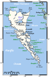
Moresby Island is a large island that forms part of the Haida Gwaii archipelago in British Columbia, Canada, located at 52°45′00″N131°50′00″W.

Roberts Creek is a community in the Sunshine Coast region of British Columbia, Canada. It is located in Area "D" of the Sunshine Coast Regional District.

The Elk/Beaver Regional Park is a 1,072-acre (434 ha) park in Saanich, British Columbia, containing Elk Lake and Beaver Lake.

Victoria Harbour is a harbour, seaport, and seaplane airport in the Canadian city of Victoria, British Columbia. It serves as a cruise ship and ferry destination for tourists and visitors to the city and Vancouver Island. It is both a port of entry and an airport of entry for general aviation. Historically it was a shipbuilding and commercial fishing centre. While the Inner Harbour is fully within the City of Victoria, separating the city's downtown on its east side from the Victoria West neighbourhood, the Upper Harbour serves as the boundary between the City of Victoria and the district municipality of Esquimalt. The inner reaches are also bordered by the district of Saanich and the town of View Royal. Victoria is a federal "public harbour" as defined by Transport Canada. Several port facilities in the harbour are overseen and developed by the Greater Victoria Harbour Authority, however the harbour master's position is with Transport Canada.
The Trial Islands Ecological Reserve is a nature reserve on the Trial Islands in the British Columbia province of Canada just off the southern tip of Oak Bay in the Strait of Juan de Fuca. The twenty-three-hectare ecological reserve was established in 1990 to protect two elongated rocky islands and associated islets. It protects the greatest number of endangered and vulnerable species in a single ecological reserve in British Columbia.
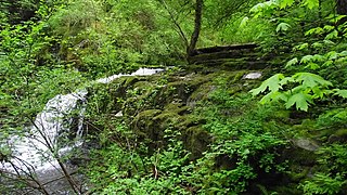
The Chemainus River is located on southern Vancouver Island, British Columbia, Canada. Its source is in the Vancouver Island Ranges, and it flows eastwards to the Strait of Georgia near the town of Chemainus, British Columbia. The valley that surrounds the river additionally includes the communities of Crofton and Westholme as well as the Halalt First Nation Reserve and several smaller reserves. Located on one of the largest islands at the mouth of the river, an old now-deserted village called Xulel-thw stands on the northeast corner; Coast Salish peoples lived there and in other now-deserted villages in the area, constantly moving throughout history.

Willis Point is a small, rural community in the Canadian province of British Columbia, located in the Juan de Fuca Electoral Area within the Capital Regional District and Greater Victoria. It is located on the Saanich Peninsula and faces north toward the Saanich Inlet. The community is bounded by the District of Highlands to the south, the District of Saanich to the southeast and the District of Central Saanich to the east. It is located west of the village of Brentwood Bay and north of the city of Victoria.
