
Victoria is a federal electoral district in British Columbia, Canada, that has been represented in the House of Commons of Canada from 1872 to 1904 and since 1925.

Swartz Bay, located on the north end of the Saanich Peninsula on Vancouver Island, is primarily known for being the location of one of BC Ferries' main terminals, the Swartz Bay Ferry Terminal. Swartz Bay was named after John Aaron Swart, purchaser in 1876 - i.e. it was meant to be Swart's Bay, but was incorrectly spelled when it was adopted by the Government. In the SENĆOŦEN language spoken by Indigenous W̱SÁNEĆ people of the area, its name is ŚJEL¸KES.

Central Saanich is a district municipality in Greater Victoria, British Columbia, Canada, and a member municipality of the Capital Regional District. It is located on the Saanich Peninsula, in the far south-east of Vancouver Island. It is the traditional territory of the W̱SÁNEĆ people. The district began as a farming community, and many hobby farms, along working farms and vineyards, still exist. In recent decades, the area has seen increasing residential, commercial, and industrial development, especially around the neighbourhoods of Brentwood Bay and Saanichton, which are occasionally referred to as separate communities.
The Q Centre is in Colwood, British Columbia, Canada. In 2014, the arena was named "The Q Centre" after local radio station CKKQ-FM. The arena opened in February 2004, has 2,300 seats and houses year-round events for hockey and lacrosse. With an additional floor capacity of 860 people and standing room area for up to 480, this premier spectator facility can hold any type of event, from trade shows to major sporting and entertainment events.

Saanich North and the Islands is a provincial electoral district for the Legislative Assembly of British Columbia, Canada. It is located in the northern suburbs of the provincial capital, Victoria, and includes the southern Gulf Islands.

The Galloping Goose Regional Trail is a 55-kilometre (34 mi) rail trail between Victoria, British Columbia, Canada, and the ghost town of Leechtown, north of Sooke, where it meets the old Sooke Flowline. Maintained by the Capital Regional District (CRD), the trail forms part of the Trans-Canada Trail, and intersects the Lochside Regional Trail. The section from Harbour Road in Esquimalt to the Veterans Memorial Parkway in Langford is also part of the Vancouver Island Trail.
Brentwood Bay is a small village in the municipality of Central Saanich, on the Saanich Peninsula in British Columbia, Canada. It lies north of the city of Victoria, east of the community of Willis Point, and south of the town of Sidney.

Malahat is an unincorporated area in the Cowichan Valley, with municipal-type services delivered by the Cowichan Valley Regional District. What could be considered the hub of the community is a small collection of businesses that includes the Malahat Gas station and the Malahat Chalet and the Moon Water Lodge.
Saanich Peninsula is located north of Victoria, British Columbia, Canada. It is bounded by Saanich Inlet on the west, Satellite Channel on the north, the small Colburne Passage on the northeast, and Haro Strait on the east. The exact southern boundary of what is referred to as the "Saanich Peninsula" is somewhat fluid in local parlance.
Bamberton is an industrial site located on the Saanich Inlet, just south of Mill Bay, around 45 kilometres north of Victoria on Vancouver Island.

Patricia Bay is a body of salt water that extends east from Saanich Inlet and forms part of the shoreline of North Saanich, British Columbia. It lies due west of Victoria International Airport. A municipal park covers most of its eastern shore except at the southern end, which is home to a Canadian Coast Guard base, a seaplane port known as Victoria Airport Water Aerodrome, and two Canadian Government research facilities – the Institute of Ocean Sciences and GSC Pacific Sidney.

Active Pass is a strait separating Galiano Island in the north and Mayne Island in the south in the southern Gulf Islands, British Columbia, Canada. It connects the Trincomali Channel in the west and the Strait of Georgia in the east. The pass stretches 5.5 km from northeast to southwest with two roughly right-angle bends, one at each end.

Gordon Head is a seaside neighbourhood in the municipality of Saanich in Greater Victoria, British Columbia, Canada. Gordon Head lies north of McKenzie Avenue and east of the Blenkinsop Valley. The University of Victoria is located partly within Gordon Head along the southeast boundary. Finnerty Road separates Gordon Head from the adjacent neighbourhood of Cadboro Bay. The local area is dominated physically by Mount Douglas, a coastline along Haro Strait, and the central plateau.

Victoria Harbour is a harbour, seaport, and seaplane airport in the Canadian city of Victoria, British Columbia. It serves as a cruise ship and ferry destination for tourists and visitors to the city and Vancouver Island. It is both a port of entry and an airport of entry for general aviation. Historically it was a shipbuilding and commercial fishing centre. While the Inner Harbour is fully within the City of Victoria, separating the city's downtown on its east side from the Victoria West neighbourhood, the Upper Harbour serves as the boundary between the City of Victoria and the district municipality of Esquimalt. The inner reaches are also bordered by the district of Saanich and the town of View Royal. Victoria is a federal "public harbour" as defined by Transport Canada. Several port facilities in the harbour are overseen and developed by the Greater Victoria Harbour Authority, however the harbour master's position is with Transport Canada.

Portland Island is an island of the Southern Gulf Islands of the South Coast of British Columbia, Canada. It is located in the Salish Sea west of Moresby Island and off the south tip of Saltspring Island, adjacent to the main BC Ferries route just offshore from the terminal at Swartz Bay at the tip of the Saanich Peninsula. It was named after HMS Portland, the flagship of Rear-Admiral Fairfax Moresby, Commander in Chief of the Pacific Station 1850–1853.
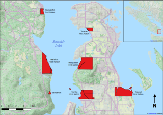
The Tseycum First Nation is a First Nations government located on Vancouver Island. In the 1850s, they were signatories to the Douglas Treaties.
Saanich Commonwealth Place is a recreation center located west of the Patricia Bay Highway and north of Royal Oak Drive in Saanich, British Columbia in Canada. It was originally constructed in 1993 for the August 1994 Commonwealth Games, and is currently a facility in the community. In 2002 the original weightroom was completely renovated and it re-opened for operation in 2004. Among the center's other features are a full-size gymnasium, a 50-meter competition pool, 4.5 meter deep dive tank with 1-, 3-, 5-, 7.5-, and 10-meter boards, and the Bruce Hutchison Branch of the Greater Victoria Public Library. The building's construction features a red dome in the shape of a slightly flattened square pyramid over the main pool area. The inside of the dome has dozens of large, intricately engineered sound absorption ceiling panels. Finally, stretching from about one-sixth to one-third of the way down the pyramid dome's four massive triangular sides, angled multi-pane windows replace the ceiling panels as the focus of a backstroker's view. The facility is often referred to as the "Commonwealth Pool" by residents of Greater Victoria.
The Saanich Pioneer Museum is a museum dedicated to the history and settling pioneers of the Saanich Peninsula in Canada. It is located in the village of Saanichton, British Columbia.
SS Iroquois was a Canadian steamboat ferry active in British Columbia, Canada. She was launched on 19 February 1900 at Port Moody. She ran from Sidney to Nanaimo, making stops at the southern Gulf Islands. In 1902, she was taken out of service, replaced by Strathcona. Three months later, Strathcona broke down, and Iroquois was returned to service.
The Victoria and Sidney Railway Company (V&S) was one of three railways to operate on the Saanich Peninsula of southern Vancouver Island, British Columbia. Opened in 1894 the route largely closed in 1919 but a section of track remained in use until 1935.
