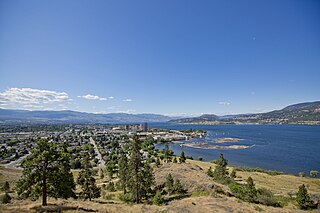
Kelowna is a city on Okanagan Lake in the Okanagan Valley in the southern interior of British Columbia, Canada. It serves as the head office of the Regional District of Central Okanagan. The name Kelowna derives from the Okanagan word kiʔláwnaʔ, referring to a grizzly bear.
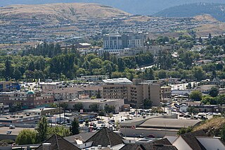
Vernon is a city in the Okanagan region of the Southern Interior of British Columbia, Canada. It is 440 km (270 mi) northeast of Vancouver. Named after Forbes George Vernon, a former MLA of British Columbia who helped establish the Coldstream Ranch in nearby Coldstream, the City of Vernon was incorporated on 30 December 1892. The City of Vernon has a population of 40,000 (2013), while its metropolitan region, Greater Vernon, had a population of 58,584 as of the 2011 Canadian census. With this population, Vernon is the largest city in the North Okanagan Regional District. A resident of Vernon is called a "Vernonite".
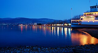
Penticton is a city in the Okanagan Valley of the Southern Interior of British Columbia, Canada, situated between Okanagan and Skaha lakes. In the 2016 Canadian Census, its population was 33,761, while its census agglomeration population was 43,432.

Cranbrook is a city in southeast British Columbia, Canada, located approximately 10 km southwest of the confluence of the Kootenay River and the St. Mary's River. It is the largest urban centre in the region known as the East Kootenay. As of 2016, Cranbrook's population is 20,499 with a census agglomeration population of 27,040. It is the location of the headquarters of the Regional District of East Kootenay and also the location of the regional headquarters of various provincial ministries and agencies, notably the Rocky Mountain Forest District.

The Okanagan, also called the Okanagan Valley and sometimes the Okanagan Country, is a region in the Canadian province of British Columbia defined by the basin of Okanagan Lake and the Canadian portion of the Okanagan River. It is part of the Okanagan Country, extending into the United States as Okanogan County in north-central Washington. According to the 2016 Canadian census, the region's population is 362,258. The largest populated cities are Kelowna, Penticton, Vernon, and West Kelowna.
Highway 97 is a major highway in the Canadian province of British Columbia. It is the longest continuously numbered route in the province, running 2,081 km (1,293 mi) and is the only route that runs the entire north–south length of the British Columbia, connecting the Canada–United States border near Osoyoos in the south to the British Columbia–Yukon boundary in the north at Watson Lake, Yukon.

Burns Lake is a rural village in the North-western-Central Interior of British Columbia, Canada, incorporated in 1923. The village had a population of 1,659 as of the 2021 Census.

Armstrong, officially the City of Armstrong is a city in the North Okanagan of the Canadian province of British Columbia, between Vernon and Enderby. It overlooks the Spallumcheen Valley, which forms a broad pass between the Okanagan Valley to the south and the Shuswap Country to the north, and is about 480 km (300 mi) from each of Vancouver, B.C. and Spokane, Washington. The town of Armstrong celebrated its centennial in 2013.

Oliver is a town near the south end of the Okanagan Valley in the Southern Interior of British Columbia, Canada, with a population of nearly 5,000 people. It is located along the Okanagan River by Tuc-el-nuit Lake between Osoyoos and Okanagan Falls, and is labelled as the Wine Capital of Canada by Tourism British Columbia. It was once "The Home of the Cantaloupe" as well as the "Home of the International Horseshow."

The Regional District of Central Okanagan (RDCO) is a regional district in the Canadian province of British Columbia, representing two unincorporated Electoral Areas of Central Okanagan East and Central Okanagan West, along with the member municipalities of the City of Kelowna, City of West Kelowna the District of Lake Country, the District of Peachland and Westbank First Nation. The RDCO office is located in Kelowna.

Westbank is one of the communities within the City of West Kelowna in the province of British Columbia. It is 12 km to the west of Kelowna. Other communities in West Kelowna include Casa Loma, West Kelowna Estates, Shannon Lake, Smith Creek, Glenrosa, Rose Valley and Lakeview Heights. Westbank sits to the south of West Kelowna.

Lake Country is a district municipality with a population of approximately 15,000 in the Okanagan Valley region of British Columbia, Canada. It is a part of the Central Okanagan Regional District, and of the Kelowna metropolitan area. The city of Kelowna lies to the south, while the city of Vernon lies to the north. As its name suggests, there are a number of lakes in the vicinity of Lake Country, and outside the municipal boundaries in the hills to the east. Okanagan Lake defines the western boundary of the municipality, while the entirety of Wood Lake and the southernmost portion of Kalamalka Lake are encompassed by it.

Big White Ski Resort, simply known as Big White, is a ski resort located 56 km (35 mi) southeast of Kelowna in the Southern Interior of British Columbia. It is located on Big White Mountain, the highest summit in the Okanagan Highland, an upland area between the Monashee Mountains and the Okanagan Valley. Big White is the fourth largest resort in British Columbia, after Whistler-Blackcomb, Sun Peaks, and Silver Star. In 2019, Big White was nominated as the third-best ski resort in Canada by Snowpak.
The UBC's Okanagan Campus is one of the University of British Columbia's campus' located in Kelowna, British Columbia, Canada.

The Okanagan Country, also known as the Okanagan Valley, is a region located in the Canadian province of British Columbia and the U.S. state of Washington, defined by the basin of Okanagan Lake and the Okanagan River. With an estimated 400,000 residents, the Okanagan Country spans from the Thompson Plateau near Grindrod, British Columbia in the Okanagan to the Okanagan Highland near Douglas County, Washington in the Okanogan. The largest city in the Canadian portion is Kelowna, with a metropolitan population of 222,162 residents as of 2021, while the largest city in the American portion is Omak, with 4,860 residents as of 2020. The region took its current name in honor of the Okanagan term, ukʷnaqín. The mild climate and close proximity to lakes, rivers and mountainous regions make the Okanagan Country an outdoor recreational destination. The region's economy is dominated by the primary sector industries of agriculture and forestry, although economic diversification has also occurred with retirement communities and recreational tourism. The American portion is considered to be more remote than the Canadian division, with approximately 10 percent of the population.

West Kelowna, formerly known as Westbank and colloquially known as Westside, is a city in British Columbia's Okanagan Valley. The city encompasses several distinct neighbourhoods, including Casa Loma, Gellatly, Glenrosa, Lakeview Heights, Shannon Lake, Smith Creek, Rose Valley, Westbank, and West Kelowna Estates. West Kelowna had an estimated population of 34,883 as of December 31, 2018.

Kelowna Regional Transit System is operated by FirstCanada, providing public bus transportation services in part of the central Okanagan Valley of British Columbia, Canada. Funding for the transit system is shared between the City of Kelowna, Regional District of Central Okanagan, District of Lake Country, City of West Kelowna, Westbank First Nation and BC Transit, while the planning and routing decisions are primarily made by Kelowna City Council. Kelowna Regional Transit was one of the first public transit systems in Canada to have double-decker buses, and the first in Canada to have hybrid buses on regular routes. The hybrid and double deckers buses have since been relocated to Victoria.

Oyama is a neighbourhood and formal ward located within the district municipality of Lake Country, which is located in the Okanagan region in British Columbia, Canada. It is located at the north end of Wood Lake and at the south end of Kalamalka Lake opposite BC Highway 97.

Okanagan Centre is a neighbourhood and formal ward within Lake Country, British Columbia, Canada. It is on the east shore of Okanagan Lake to the north of Kelowna and just northwest of Winfield, another wards of the District of Lake Country.


