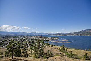
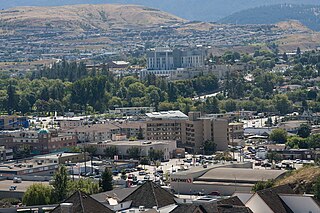
Kelowna is a city on Okanagan Lake in the Okanagan Valley in the southern interior of British Columbia, Canada. It serves as the head office of the Regional District of Central Okanagan. The name Kelowna derives from the Okanagan word kiʔláwnaʔ, referring to a male grizzly bear.
Vernon is a city in the Okanagan region of the Southern Interior of British Columbia, Canada. It is 440 km (270 mi) northeast of Vancouver. Named after Forbes George Vernon, a former MLA of British Columbia who helped establish the Coldstream Ranch in nearby Coldstream, the City of Vernon was incorporated on December 30, 1892. The City of Vernon has a population of 40,000 (2013), while its metropolitan region, Greater Vernon, has a population of 58,584 as of the Canada 2011 Census. With this population, Vernon is the largest city in the North Okanagan Regional District. A resident of Vernon is called a "Vernonite".
Penticton is a city in the Okanagan Valley of the Southern Interior of British Columbia, Canada, situated between Okanagan and Skaha lakes. In the 2016 Canadian Census, its population was 33,761, while its census agglomeration population was 43,432.

Kalamalka Lake is a large lake in the interior plateau of southern central British Columbia, Canada, east of Okanagan Lake. The lake is located approximately 4 kilometres (2.5 mi) south of the city of Vernon and is its main drinking water supply. The lake is named after the Okanagan First Nation chief who occupied its northern shores.

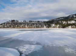
The Okanagan, also known as the Okanagan Valley and sometimes as the Okanagan Country, is a region in the Canadian province of British Columbia defined by the basin of Okanagan Lake and the Canadian portion of the Okanagan River. It is part of the Okanagan Country, extending into the United States as Okanogan County in north-central Washington. According to the 2016 Canadian census, the region's population is 362,258. The largest populated cities are Kelowna, Penticton, Vernon, and West Kelowna.
Highway 97 is the longest continuously numbered route in the Canadian province of British Columbia, running 2,081 km (1,293 mi) from the Canada–United States border near Osoyoos in the south to the British Columbia/Yukon boundary in the north at Watson Lake, Yukon. The route takes its number from U.S. Route 97, with which it connects at the international border. The highway was initially designated '97' in 1953.

Osoyoos is the southernmost town in the Okanagan Valley in British Columbia between Penticton and Omak. The town is 3.6 km (2.2 mi) north of the United States border with Washington state and is adjacent to the Osoyoos Indian reserve. The origin of the name Osoyoos was the word sw̓iw̓s meaning "narrowing of the waters" in the local Okanagan language (Syilx'tsn). The "O-" prefix is not indigenous in origin and was attached by settler-promoters wanting to harmonize the name with other place names beginning with O in the Okanagan region. There is one local newspaper, the Osoyoos Times.

The City of Armstrong is located in the North Okanagan of the Canadian province of British Columbia, between Vernon and Enderby. It overlooks the Spallumcheen Valley, which forms a broad pass between the Okanagan Valley to the south and the Shuswap Country to the north, and is about 480 km (300 mi) from each of Vancouver, B.C. and Spokane, Washington. The town of Armstrong celebrated its centennial in 2013.

Oliver is a town near the south end of the Okanagan Valley in the Southern Interior of British Columbia, Canada, with a population of nearly 5,000 people. It is located along the Okanagan River by Tuc-el-nuit Lake between Osoyoos and Okanagan Falls, and is labeled as the Wine Capital of Canada by Tourism British Columbia. It was once "The Home of the Cantaloupe" as well as the "Home of the International Horseshow."

Peachland is a district municipality in the Okanagan Valley on the west side of Okanagan Lake in British Columbia, Canada. It was founded in 1899 by John Moore Robinson, although the region had long been home to the Okanagan people. Peachland is approximately half-an-hour's drive south of the city of Kelowna and about a 20-minute drive north of Summerland. The Okanagan Valley is very narrow in the area and there are few terraces that mark former lake levels and the former lake bottom. As a result, the city is largely located on a steep sidehill. Like many other areas in the Okanagan, Peachland is rapidly growing, with new residents coming from all across Canada. Across the lake from Peachland is Rattlesnake Island, home of the legendary Ogopogo. Peachland is approximately 370 km from Vancouver, British Columbia, on the British Columbia south coast.

The Regional District of Central Okanagan (RDCO) is a regional district in the Canadian province of British Columbia, comprising the City of Kelowna, City of West Kelowna and their surrounding municipalities. The regional district's offices are located in Kelowna.
Wood Lake is a lake in a chain of five major lakes which occupies portions of the Okanagan Valley in the interior of British Columbia, Canada. The lakes of the Okanagan Valley were formed by about 8900 BP. Wood Lake is immediately south of Kalamalka Lake and in 1908 was connected to it by a dredged channel. Situated between Oyama and Winfield, it has a solid reputation for rainbow trout fishing. The lake is named after Tom Wood, who settled on the south end of the lake around 1860.

The Monashee Mountains are a mountain range lying mostly in British Columbia, Canada, extending into the U.S. state of Washington. They stretch 530 km (329 mi) from north to south and 150 km (93 mi) from east to west. They are a sub-range of the Columbia Mountains. The highest summit is Mount Monashee, which reaches 3,274 m (10,741 ft). The name is from the Scottish Gaelic monadh and sìth, meaning "moor" and "peace".

Lake Country is a district municipality with a population of approximately 15,000 in the Okanagan Valley region of British Columbia, Canada. It is a part of the Central Okanagan Regional District, and of the Kelowna metropolitan area. The city of Kelowna lies to the south, while the city of Vernon lies to the north. As its name suggests, there are a number of lakes in the vicinity of Lake Country, and outside the municipal boundaries in the hills to the east. Okanagan Lake defines the western boundary of the municipality, while the entirety of Wood Lake and the southernmost portion of Kalamalka Lake are encompassed by it.
Winfield is a neighbourhood and formal ward within the District Municipality of Lake Country, British Columbia, located adjacent to the northern city boundary of Kelowna.
School District 23 Central Okanagan is a school district in the Okanagan valley of British Columbia. It includes the cities of Kelowna, and West Kelowna, and the District Municipalities of Lake Country, and Peachland, and is the 5th largest district in BC. The boundaries of the school district are identical to those of the Regional District of Central Okanagan.
The British Columbia Interior, popularly referred to as the BC Interior or simply the Interior, is a geographic region of the Canadian province of British Columbia. While the exact boundaries are variously defined, the British Columbia Interior is generally defined to include the 14 regional districts that do not have coastline along the Pacific Ocean or Salish Sea, and are not part of the Lower Mainland. Other boundaries may exclude parts of or even entire regional districts, or expand the definition to include the regional districts of Fraser Valley, Squamish–Lillooet, and Kitimat–Stikine.
Spallumcheen is a district municipality in the Canadian province of British Columbia. Located in the Okanagan region between Vernon and Enderby, the township had a population of 5,055 and land area of 255.77 square kilometres (98.75 sq mi) in the Canada 2011 Census. The district, whose official name is the Township of Spallumcheen and which is the oldest rural municipality in the British Columbia Interior, consists primarily of agricultural land surrounding the separately incorporated City of Armstrong. Both Spallumcheen and Armstrong are member municipalities of the Regional District of North Okanagan.

The Okanagan Country, also known as the Okanagan Valley, is a region located in the Canadian province of British Columbia and the U.S. state of Washington, defined by the basin of Okanagan Lake and the Okanagan River. With an estimated 400,000 residents, the Okanagan Country spans from the Thompson Plateau near Grindrod, British Columbia in the Okanagan to the Okanagan Highland near Douglas County, Washington in the Okanogan. The largest city in the Canadian portion is Kelowna, with a metropolitan population of 194,882 residents as of 2016, while the largest city in the American portion is Omak, with 4,881 residents as of 2011. The region took its current name in honor of the Okanagan term, ukʷnaqín. The mild climate and close proximity to lakes, rivers and mountainous regions make the Okanagan Country an outdoor recreational destination. The region's economy is dominated by the primary sector industries of agriculture and forestry, although economic diversification has also occurred with retirement communities and recreational tourism. The American portion is considered to be more remote than the Canadian division, with approximately 10 percent of the population.

West Kelowna, formerly known as Westbank and colloquially known as Westside, is a city in British Columbia's Okanagan Valley. The city encompasses several distinct neighbourhoods, including Casa Loma, Gellatly, Glenrosa, Lakeview Heights, Shannon Lake, Smith Creek, Rose Valley, Westbank, and West Kelowna Estates. West Kelowna had an estimated population of 34,883 as of December 31, 2018.