The Mackenzie River is a river in the Canadian boreal forest. It forms, along with the Slave, Peace, and Finlay, the longest river system in Canada, and includes the second largest drainage basin of any North American river after the Mississippi.
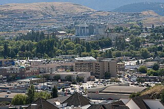
Vernon is a city in the Okanagan region of the Southern Interior of British Columbia, Canada. It is 440 km (270 mi) northeast of Vancouver. Named after Forbes George Vernon, a former MLA of British Columbia who helped establish the Coldstream Ranch in nearby Coldstream, the City of Vernon was incorporated on 30 December 1892. The City of Vernon has a population of 40,000 (2013), while its metropolitan region, Greater Vernon, had a population of 58,584 as of the 2011 Canadian census. With this population, Vernon is the largest city in the North Okanagan Regional District. A resident of Vernon is called a "Vernonite".

Kalamalka Lake is a large lake in the interior plateau of southern central British Columbia, Canada, east of Okanagan Lake. The lake is located approximately 4 kilometres (2.5 mi) south of the city of Vernon and is its main drinking water supply. The lake is named after the Okanagan First Nation chief who occupied its northern shores.

Okanagan Lake is a lake in the Okanagan Valley of British Columbia, Canada. The lake is 135 km (84 mi) long, between 4 and 5 km wide, and has a surface area of 348 km2.

The Okanagan, also called the Okanagan Valley and sometimes the Okanagan Country, is a region in the Canadian province of British Columbia defined by the basin of Okanagan Lake and the Canadian portion of the Okanagan River. It is part of the Okanagan Country, extending into the United States as Okanogan County in north-central Washington. According to the 2016 Canadian census, the region's population is 362,258. The largest populated cities are Kelowna, Penticton, Vernon, and West Kelowna.
Highway 97 is a major highway in the Canadian province of British Columbia. It is the longest continuously numbered route in the province, running 2,081 km (1,293 mi) and is the only route that runs the entire north–south length of British Columbia, connecting the Canada–United States border near Osoyoos in the south to the British Columbia–Yukon boundary in the north at Watson Lake, Yukon.

The Okanogan River is a tributary of the Columbia River, approximately 115 mi (185 km) long, in southern British Columbia and north central Washington. It drains a scenic plateau region called the Okanagan Country east of the Cascade Range and north and west of the Columbia, and also the Okanagan region of British Columbia. The Canadian portion of the river has been channelized since the mid-1950s.

Lake Country is a district municipality with a population of approximately 15,000 in the Okanagan Valley region of British Columbia, Canada. It is a part of the Central Okanagan Regional District, and of the Kelowna metropolitan area. The city of Kelowna lies to the south, while the city of Vernon lies to the north. As its name suggests, there are a number of lakes in the vicinity of Lake Country, and outside the municipal boundaries in the hills to the east. Okanagan Lake defines the western boundary of the municipality, while the entirety of Wood Lake and the southernmost portion of Kalamalka Lake are encompassed by it.

Kalamalka Lake Provincial Park and Protected Area is a provincial park in Coldstream, British Columbia, Canada. Located within the Okanagan region, the park encompasses a land area of about 978 hectares of pristine natural areas in the North Okanagan Regional District. Kalamalka Lake Provincial Park and Protected Area adopted its current name from Kalamalka Lake, for which it is located on its shore. During the process of entering summer, calcium carbonate forms crystals that reflect sunlight and create the vivid blue and green colours. Temperature changes in the fall and the spring sometimes create ribbons of deep blue colour in the lake, seen from the park.
Coldstream is a district municipality in British Columbia, Canada, located at the northern end of Kalamalka Lake in the Okanagan Valley. Incorporated on December 21, 1906, Coldstream celebrated its centennial in 2006. The municipality is directly southeast of Vernon and is considered part of Greater Vernon. It is a member municipality of, and also the location of the head offices, of the Regional District of North Okanagan.
The Okanagan Highland is an elevated hilly plateau area in British Columbia, Canada, and the U.S. state of Washington. Rounded mountains with elevations up to 8,000 ft (2,400 m) above sea level and deep, narrow valleys are characteristic of the region.
The Okanagan Basin spans two countries and comprises the basin of Okanagan Lake, the Okanogan River and tributary valleys such as that of the Similkameen and Chelan Rivers. In Canada the basin constitutes two distinct regions within British Columbia, the Similkameen Country to the west and the main Okanagan region running from the communities of Osoyoos in the south to Armstrong in the north – incorporating most of the three Okanagan regional districts and is usually known as "the Okanagan" or as the Okanagan Valley or the Okanagan Country. In the United States, the Okanogan Country is the western, lowland core of Okanogan County, which like its Canadian counterpart has a history and economy based on ranching, gold, fruit orcharding and vineyards, but the basin includes Lake Chelan and other flanking valleys. Communities in Washington's Okanogan Basin include Pateros, Omak, Okanogan, Oroville and Brewster.

Vaseux Lake is a shallow freshwater lake located along the course of the Okanagan River in the Okanagan Valley of British Columbia, Canada.

The Okanagan Country, also known as the Okanagan Valley, is a region located in the Canadian province of British Columbia and the U.S. state of Washington, defined by the basin of Okanagan Lake and the Okanagan River. With an estimated 400,000 residents, the Okanagan Country spans from the Thompson Plateau near Grindrod, British Columbia in the Okanagan to the Okanagan Highland near Douglas County, Washington in the Okanogan. The largest city in the Canadian portion is Kelowna, with a metropolitan population of 222,162 residents as of 2021, while the largest city in the American portion is Omak, with 4,860 residents as of 2020. The region took its current name in honor of the Okanagan term, ukʷnaqín. The mild climate and close proximity to lakes, rivers and mountainous regions make the Okanagan Country an outdoor recreational destination. The region's economy is dominated by the primary sector industries of agriculture and forestry, although economic diversification has also occurred with retirement communities and recreational tourism. The American portion is considered to be more remote than the Canadian division, with approximately 10 percent of the population.
The Okanagan Basin Water Board (OBWB) is a water governance body designated to identify and resolve critical water issues for the Okanagan watershed in British Columbia, Canada. It was set up to implement the recommendations of the Okanagan Basin Study, and to take on a range of responsibilities for water management. The OBWB’s jurisdiction is defined by the geographic borders of the Okanagan Basin rather than political boundaries.

The Okanagan Valley wine region, located within the region of the same name in the British Columbia Interior, is Canada's second-largest wine producing area. Along with the nearby Similkameen Valley, the approximately 8,619 acres of vineyards planted in the Okanagan account for more than 80% of all wine produced in British Columbia, and are second in economic importance for wine production to the Niagara Peninsula of Ontario. Some 182 licensed wineries existed from south to north in the valley in 2018, with many situated along the 135 km (84 mi)-long Okanagan Lake and its tributaries and downstream lakes, including Skaha Lake, Vaseux Lake, and Osoyoos Lake. The Okanagan has diverse terrain that features many different microclimates and vineyard soil types, contributing characteristics which are part of an Okanagan terroir.

Oyama is a neighbourhood and formal ward located within the district municipality of Lake Country, which is located in the Okanagan region in British Columbia, Canada. It is located at the north end of Wood Lake and at the south end of Kalamalka Lake opposite BC Highway 97.

Richard J. "Dick" Cannings is a Canadian biologist, author and politician. He was elected as the South Okanagan—West Kootenay Member of Parliament in the 2015 Canadian federal election for the New Democratic Party, and re-elected in 2019. As a member of the 42nd Canadian Parliament he sponsored three private member's bills: one to promote the use of wood in federal public works projects, one to add various lakes and rivers to Navigable Waters Protection Act, and another to a Minister of Environment to respond to a Committee on the Status of Endangered Wildlife in Canada report. Cannings was appointed the NDP Critic for Post-Secondary Education as well as the Deputy Critic for Natural Resources in the 42nd Canadian Parliament. He became the NDP Critic for Natural Resources in 2016 and served in that position until 2021. In October 2021, he became the NDP Critic for Emergency Preparedness and Critic for Small Business and Tourism, as well as Deputy Critic for Natural Resources and Deputy Critic for Innovation, Science and Industry. In December 2021, he was named an inaugural member of the House of Commons Standing Committee on Science and Research.
Rita Winkler is a Canadian Research Hydrologist working at the British Columbia Ministry of Forests, Lands and Natural Resource Operations

White Lake Grasslands Protected Area is a conservation site located in the Regional District of Okanagan-Similkameen of British Columbia, Canada. It was established on April 18, 2001 by an order-in-council under the Environment and Land Use Act to protect the semi-arid grassland and pine forest ecosystem west of Vaseux Lake.