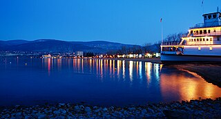
Penticton is a city in the Okanagan Valley of the Southern Interior of British Columbia, Canada, situated between Okanagan and Skaha lakes. In 2016, its population was 33,761, while its census agglomeration population was 43,432.

Osoyoos is the southernmost town in the Okanagan Valley in British Columbia between Penticton and Omak. The town is 3.6 kilometres (2.2 mi) north of the United States border with Washington state and is adjacent to the Osoyoos Indian Reserve. The origin of the name Osoyoos was the word sẁiẁs meaning "narrowing of the waters" in the local Okanagan language (Syilx'tsn). The "O-" prefix is not indigenous in origin and was attached by settler-promoters wanting to harmonize the name with other place names beginning with O in the Okanagan region. There is one local newspaper, the Osoyoos Times.

Oliver is a town near the south end of the Okanagan Valley in the Southern Interior of British Columbia, Canada, with a population of over 4,000 people. It is located along the Okanagan River by Tuc-el-nuit Lake between Osoyoos and Okanagan Falls, and is labeled as the Wine Capital of Canada by Tourism British Columbia.

Peachland is a district municipality of over 5000 residents in the Okanagan Valley. It is located on the west side of Okanagan Lake in British Columbia, Canada. It was founded in 1899 by John Moore Robinson, although the region had long been home to the Okanagan people. Peachland is approximately a half-hour's drive south of the city of Kelowna and about a 20-minute drive north of Summerland. The Okanagan Valley is very narrow in this area, and there are few terraces that mark former lake levels and the former lake bottom. As a result, the city is largely located on a steep sidehill. Like many areas in the Okanagan, Peachland is a rapidly growing community, with new residents coming from all across Canada. Across the lake from Peachland is Rattlesnake Island, home of the legendary Ogopogo. Peachland is approximately 370 km from Vancouver, British Columbia, on the BC South Coast.
Kaleden is a small historic, and modern rural satellite community located south of Penticton in the Okanagan Valley in the province of British Columbia, Canada. The community of 4.32 kilometres (2.68 mi), with its population of 1,224, is located about 16 kilometres (9.9 mi) south of Penticton along Skaha Lake in the South Okanagan and Okanagan-Similkameen. Kaleden was established by James Ritchie in the early 1900s for growing fruit. The famous "Kaleden Cots" got their beginning here. From the community beginnings as a small orcharding community, the town has evolved from fruit to vineyards and has become a bedroom community of Penticton.
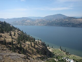
Skaha Lake, historically known as Dog Lake and originally Lac Du Chien, is a freshwater lake located along the course of the Okanagan River in the Okanagan Valley of British Columbia, Canada. It has a surface area of approximately 20 km², with a maximum depth of 55 metres. The lake is situated directly south of Okanagan Lake and forms the southern shoreline and boundary of the city of Penticton, British Columbia. The community of Okanagan Falls is located at its southern end, the community of Kaleden lies in the upland area to its west.
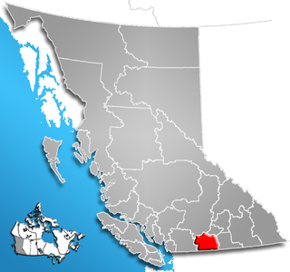
The Regional District of Okanagan-Similkameen (RDOS) is in southern British Columbia, adjacent to the U.S. state of Washington. It is bounded by Fraser Valley Regional District to the west, Thompson-Nicola Regional District and Regional District of Central Okanagan to the north, Regional District of Kootenay Boundary to the east, and by Okanogan County, Washington to the south. At the 2011 census the population was 80,742. The district covers a land area of 10,413.44 square kilometres (4,020.65 sq mi). The administrative offices are in the City of Penticton.

The Okanagan people, also spelled Okanogan, are a First Nations and Native American people whose traditional territory spans the Canada–US boundary in Washington state and British Columbia in the Okanagan Country region. They call themselves the Syilx, a term now widely used. They are part of the Interior Salish ethnological and linguistic grouping. The Okanagan are closely related to the Spokan, Sinixt, Nez Perce, Pend Oreille, Secwepemc and Nlaka'pamux peoples of the same Northwest Plateau region.
The Similkameen Country, also referred to as the Similkameen Valley or Similkameen District, but generally referred to simply as The Similkameen or more archaically, Similkameen, is a region roughly coinciding with the basin of the river of the same name in the Southern Interior of British Columbia. The term "Similkameen District" also refers to the Similkameen Mining District, a defunct government administrative district, which geographically encompasses the same area, and in more casual terms may also refer to the Similkameen electoral district, which was combined with the Grand Forks-Greenwood riding by the time of the 1966 election. The Similkameen Country has deep historical connections to the Boundary Country and the two are sometimes considered one region, partly as a result of the name of the electoral district. It is also sometimes classed as being part of the Okanagan region, which results from shared regional district and other administrative boundaries and names. The term "Similkameen District" may also historically refer to the Similkameen Division Yale Land District, which also includes Osoyoos and the Boundary Country to Osoyoos' east.

The Okanagan Desert is the common name for a semi-arid area located in the South Okanagan Valley region of British Columbia, Canada, primarily around the town of Osoyoos. Part of the area is called the Nk'mip Desert by the Osoyoos Indian Band, though the entire region, like other similar parts of the British Columbia Interior, is technically a semi-arid shrub-steppe.

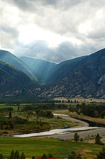
The Okanagan Country, also known as the Okanagan Valley, is a region located in the Canadian province of British Columbia, and the U.S. state of Washington, defined by the basin of Okanagan Lake and the Okanagan River. With an estimated 400,000 residents, the Okanagan Country spans from the Thompson Plateau near Grindrod, British Columbia in the Okanagan to the Okanagan Highland near Douglas County, Washington in the Okanogan. The largest city in the Canadian portion is Kelowna, with a metropolitan population of 194,882 residents as of 2016, while the largest city in the American portion is Omak, with 4,881 residents as of 2011. The region took its current name in honor of the Okanagan term, ukʷnaqín. The mild climate and close proximity to lakes, rivers and mountainous regions make the Okanagan Country an outdoor recreational destination. The region's economy is dominated by the primary industries of agriculture and forestry, although economic diversification has also occurred with retirement communities and recreational tourism. The American portion is considered to be more remote than the Canadian division, with approximately 10 percent of the population.
CKOR is a Canadian radio station in Penticton, British Columbia. Bell Media owns the station, which operates at 800 AM with 10,000 watts of transmission power in the daytime and 500 watts at night, and airs an adult contemporary music format under the EZ Rock brand. CKOR uses a non-directional antenna at all times.

Penticton Transit provides local public transportation services in the City of Penticton in the Okanagan Valley of British Columbia, Canada, with a fleet of fully accessible low floor transit buses. The system consists of eight scheduled routes serving the city, which includes a night route; a connecting service by Okanagan-Similkameen Transit to the community of Naramata; a summer lake-to-lake route; and a HandyDART service for people who are unable to use regular transit.