
Puget Sound is a complex estuarine system of interconnected marine waterways and basins located on the northwest coast of the U.S. state of Washington. As a part of the Salish Sea, the sound has one major and two minor connections to the Strait of Juan de Fuca, which in turn connects to the open Pacific Ocean. The major connection is Admiralty Inlet; the minor connections are Deception Pass and the Swinomish Channel.

North Cascades National Park is a national park of the United States in Washington. At more than 500,000 acres (200,000 ha), it is the largest of the three National Park Service units that comprise the North Cascades National Park Complex. North Cascades National Park consists of a northern and southern section, bisected by the Skagit River that flows through the reservoirs of Ross Lake National Recreation Area. Lake Chelan National Recreation Area lies on the southern border of the south unit of the park. In addition to the two national recreation areas, other protected lands including several national forests and wilderness areas, as well as Canadian provincial parks in British Columbia, nearly surround the park. North Cascades National Park features the rugged mountain peaks of the North Cascades Range, the most expansive glacial system in the contiguous United States, the headwaters of numerous waterways, and vast forests with the highest degree of flora biodiversity of any American national park.

Chelan County is a county in the U.S. state of Washington. As of the 2020 census, its population was 79,074. The county seat and largest city is Wenatchee. The county was created out of Okanogan and Kittitas Counties on March 13, 1899. It derives its name from a Chelan Indian word meaning "deep water," likely a reference to 55-mile (89 km)-long Lake Chelan, which reaches a maximum depth of 1,486 feet (453 m).

Lake Missoula was a prehistoric proglacial lake in western Montana that existed periodically at the end of the last ice age between 15,000 and 13,000 years ago. The lake measured about 7,770 square kilometres (3,000 sq mi) and contained about 2,100 cubic kilometres (500 cu mi) of water, half the volume of Lake Michigan.
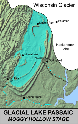
Lake Passaic was a prehistoric proglacial lake that existed in northern New Jersey in the United States at the end of the last ice age approximately 19,000–14,000 years ago. The lake was formed of waters released by the retreating Wisconsin Glacier, which had pushed large quantities of earth and rock ahead of its advance, blocking the previous natural drainage of the ancestral Passaic River through a gap in the central Watchung Mountains. The lake persisted for several thousand years as melting ice and eroding moraine dams slowly drained the former lake basin. The effect of the lake's creation permanently altered the course of the Passaic River, forcing it to take a circuitous route through the northern Watchung Mountains before spilling out into the lower piedmont.

The Skagit River is a river in southwestern British Columbia in Canada and northwestern Washington in the United States, approximately 150 mi (240 km) long. The river and its tributaries drain an area of 1.7 million acres (690,000 hectares) of the Cascade Range along the northern end of Puget Sound and flows into the sound.

Stehekin is a small unincorporated community in Chelan County, Washington. The name "Stehekin" comes from a word in the Salishan language that means "the way through". Stehekin has somewhat more than 100 permanent residents, but vacationers and seasonal workers increase its population during the summer.

Cascade Pass is a 5,392-foot (1,643 m) mountain pass over the northern Cascade Range, east of Marblemount, Washington, U.S.

Lake Whatcom is located in Whatcom County, Washington, United States. It is the drinking water source for approximately 85,000 residents in the city of Bellingham as well as Whatcom County. It is approximately 10 miles (16 km) in length and 1 mile (1.6 km) in width at its widest. Lake Whatcom is located and managed within three political jurisdictions: the city of Bellingham, Whatcom County, and the Lake Whatcom Water and Sewer District. The lake is a popular area for motor boating, swimming, fishing, and other recreational activities.

The Stehekin River is a river located in Washington state in the Pacific Northwest of the United States. It is the main river flowing into Lake Chelan. Miners arrived in Stehekin River Valley in the late 19th century. They were followed by homesteaders in the early 20th century. Today, the Stehekin River Valley is still a remote area that can only be reached by way of a 55-mile boat ride up Lake Chelan.

Lake Chelan National Recreation Area is a national recreation area located about 35 miles (56 km) south of the Canada–US border in Chelan County, Washington. It encompasses an area of 61,958 acres (25,074 ha) including the northern end of Lake Chelan and the surrounding area of the Stehekin Valley and the Stehekin River. The area is managed by the U.S. National Park Service as part of the North Cascades National Park Service Complex.

Lake Crescent is a deep lake located entirely within Olympic National Park in Clallam County, Washington, United States, approximately 17 miles (27 km) west of Port Angeles on U.S. Route 101, near the small community of Piedmont. With an official maximum depth of 624 feet (190 m), it is officially the second deepest lake in the state of Washington. A lake-wide bathymetric survey was performed from 2013 to 2014 by Eian Ray and Jeff Engea and the results of this survey show the maximum depth as being 596 feet (182 m). Using GIS statistical analysis, this survey also estimated that the lake contains around 0.5 cubic miles (2.1 km3) of fresh water.
The Baker River is an approximately 30-mile (48 km), southward-flowing tributary of the Skagit River in northwestern Washington in the United States. It drains an area of the high North Cascades in the watershed of Puget Sound north of Seattle, and east of Mount Baker. With a watershed of approximately 270 square miles (700 km2) in a complex of deep valleys partially inside North Cascades National Park, it is the last major tributary of the Skagit before the larger river reaches its mouth on Skagit Bay. The river flows through Concrete, Washington, near its mouth and has two hydroelectric dams owned by Puget Sound Energy.
Green Lake — also known as Big Green Lake — is a lake in Green Lake County, Wisconsin, United States. Green Lake has a maximum depth of 237 ft (72 m), making it the deepest natural inland lake in Wisconsin and the second largest by volume. The lake covers 29.72 km2 and has an average depth of 30.48 m (100.0 ft). Green Lake has 43.94 km (27.30 mi) of diverse shoreline, ranging from sandstone bluffs to marshes.

Lake Willoughby is located in the town of Westmore in Orleans County in the Northeast Kingdom of Vermont, United States.
The Chelan are an Interior Salish people speaking the Wenatchi dialect, though separate from that tribe. The name derives from the traditional Wenatchi name Tsi-Laan meaning "deep water".

Lake Sunapee is located within Sullivan County and Merrimack County in western New Hampshire, the United States. It is the fifth-largest lake located entirely in New Hampshire.

The Suiattle River is a river in the northern Cascade Mountains of western Washington, United States. It is a tributary of the Sauk River and by extension the Skagit River. Its source is located between Suiattle Glacier and Honeycomb Glacier on Glacier Peak, at an elevation of around 7,000 ft (2,100 m) above sea level. It descends through a 60-mile (97 km) course, lying mainly within the Mount Baker–Snoqualmie National Forest. It meets the Sauk northeast of Darrington, Washington, at an elevation of 400 ft (120 m). Snowmelt from Chocolate and Dusty Glacier gives the river silty water, with a suspended load over twice that of the upper Sauk or adjacent White Chuck.

Buckner Mountain is a tall peak in the North Cascades of Washington state and in the Stephen Mather Wilderness of North Cascades National Park. At 9,114 feet (2,778 m) in elevation it is the highest in Skagit County and one of about ten of Washington's non-volcanic peaks above 9,000 feet high. It is ranked as the 14th highest peak in the state, and the third highest peak in North Cascades National Park.
 View of Manson orchards from the south shore of Lake Chelan
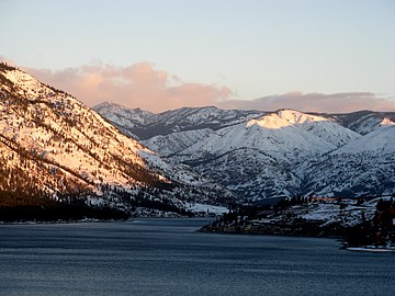 View uplake from the south shore of Lake Chelan
 View of Lake Chelan from Lakeshore trail, near Stehekin
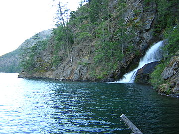 Domke Falls is the best known waterfall that drops into the lake
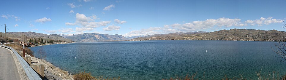 Lake Chelan as seen from the southern shore off U.S. Highway 97A


