Albion, British Columbia

Last updated

Albion, British Columbia is a neighbourhood in Maple Ridge, British Columbia and is one of several small towns incorporated within the municipality at its creation. It is the oldest non-indigenous community of the district's settlements, and is only slightly younger than Fort Langley, adjacent across the Fraser River, and Kanaka Creek, which is just to the west and lies along the creek of the same name. Its official definition is the area bounded by the Fraser River, Kanaka Way, and 240th Street, but in its historic sense it means the community centred on and flanking 240th Street and adjoining areas along the Fraser River waterfront and around the Maple Ridge Fairgrounds, while along Kanaka Way and also on the near bank of Kanaka Creek, the creek, is historically the community of Kanaka Creek. Burgeoning newer home construction east of 240th Street near the Lougheed Highway [1] is also often referred to as part of Albion.

Contents

History

Samuel Robertson and his Indigenous wife Julia were the first "European" settlers, he establishing the first fruit orchard in British Columbia two years before he permanently relocated from across the river at Fort Langley. [2] This area was originally known as East Haney, and was renamed Albion in 1907. [3] Peter Baker (originally Boulanger) was another early European settler; his name was originally used for what is now 240th Street. [4]

Trains did not stop in Albion until train personnel set a precedent by permitting one Albion resident "whose weight was not to be lightly estimated" to alight there and in this way save a long walk through a stormy evening from the stop in Haney. The next week several men demanded the same privilege, and the Albion stop on the railway was created. [5]

Sawmills, canneries and fishboats featured in Albion's economy, and River Road, which runs between the Canadian Pacific Railway tracks and the river, has been a mixed industrial area for all of Albion's existence since the coming of the railway in the 1880s. Farmland on the north side of the highway and semi-wild green fields and trees that typified the old rural community are succumbing to suburban sprawl.Langley Indian Reserve No. 5, which includes a native cemetery, is just east of Albion on the north side of the Fraser. It is one of several reserves under the jurisdiction of the Kwantlen First Nation, whose main reserve is across the Fraser from Albion on McMillan Island in Fort Langley. [6]

Albion Community Hall ALBION COMMUNITY HALL crop.jpg
Albion Community Hall

Albion Hall was built in 1923 by the Albion Community Association. It was bought by the municipality and demolished in 2011. Speaking of the hall, one proponent, looking back several decades, said:

"The people of Albion didn't travel very far afield but took pleasure in getting together with one another. Of necessity their lives were lived within walking distance of their homes. The Albion Hall was a result of this desire to get together in a place where transportation would not be a necessity.": [7]

Features

the historic Hill house on 240th Street Hill House Albion.jpg
the historic Hill house on 240th Street

Albion was the location of the free Albion Ferry terminal which, until completion of the tolled Golden Ears Bridge in 2009, connected Maple Ridge to Langley via ferry across the Fraser River. [8] [9] The Albion Fairgrounds draw people from other neighbourhoods for the Maple Ridge Country Fest [10] in July. [11] Albion Park with picnic area and some sports facilities and trails is located on 104th Avenue. [12] The Hill House, a 4,000-square-foot (370 m2) 1912 Edwardian style landmark in four storeys, is located on 240th just north of Lougheed Highway. [13]

Jackson Park

A new park is about to be added to the features of this neighbourhood, as 39 acres of rolling hills in the former John Jackson (a.k.a. Jak Huovari) farm were voted into parkland by Maple Ridge council in December 2010. This is in exchange for approval of 112 new homes on another portion of the former farm. Uses for the park acreage are yet to be determined but could include a replacement for the 1923 Albion Hall. [14]

"The Vinyl Monster"

Newer homes are filling the former farm spaces in Albion VINYL MONSTER 240 crop.jpg
Newer homes are filling the former farm spaces in Albion

At one time Albion was more remote and rural. Consistent with the rapid expansion of this neighbourhood in recent years, growth (likened to a "vinyl monster", a reference to the exterior finish of many newer area homes in an urban development which is spreading over the landscape), [15] shopping, [16] [17] [18] and crowded elementary school facilities are among issues which have motivated discussion.

Schools

Albion is served by School District 42 Maple Ridge-Pitt Meadows. Albion Elementary and Samuel Robertson Technical Secondary schools serve neighbourhood families. Samuel Robertson, named after the early settler, also entices students from other neighbourhoods because of its technical focus.

See also

Related Research Articles

Kanaka may refer to:

<span class="mw-page-title-main">Maple Ridge, British Columbia</span> City in British Columbia, Canada

Maple Ridge is a city in British Columbia, Canada. It is located in the northeastern section of Greater Vancouver between the Fraser River and the Golden Ears, which is a group of mountain summits which are the southernmost of the Garibaldi Ranges of the Coast Mountains. Maple Ridge's population in 2021 was 90,990. Its downtown core area was once known as Haney.

<span class="mw-page-title-main">West Coast Express</span> Canadian commuter railway

The West Coast Express is a commuter railway serving the Lower Mainland region of British Columbia, Canada. It is owned and operated by the region's transit authority, TransLink. Opened in 1995, it provides a link between Metro Vancouver and the Fraser Valley Regional District and is the only commuter railway in Western Canada. In 2023, the system had a ridership of 1,304,400, or about 5,600 per weekday as of the fourth quarter of 2023.

Highway 7, known for most of its length as the Lougheed Highway and Broadway, is an alternative route to Highway 1 through the Lower Mainland region of British Columbia. Whereas the controlled-access Highway 1 follows the southern bank of the Fraser River, Highway 7 follows the northern bank.

<span class="mw-page-title-main">Langley, British Columbia (city)</span> City in British Columbia, Canada

The City of Langley, commonly referred to as Langley City, or just Langley, is a municipality in the Metro Vancouver Regional District in British Columbia, Canada. It lies directly east of Surrey, adjacent to the Cloverdale area, and is surrounded elsewhere by the Township of Langley, bordered by its neighbourhoods of Willowbrook to the north, Murrayville to the east, and Brookswood and Fern Ridge to the south.

<span class="mw-page-title-main">Albion Ferry</span> Former ferry service in British Columbia, Canada

The Albion Ferry was a passenger and vehicle ferry service that sailed on the Fraser River between Albion and Fort Langley in the Lower Fraser Valley region of British Columbia, Canada from June 2, 1957, until July 31, 2009.

British Columbia K-class ferry

The K-class ferries are a group of similarly designed ferries operated by both BC Ferries and TransLink in British Columbia, Canada.

<span class="mw-page-title-main">Golden Ears Bridge</span> Bridge in Langley, British Columbia, Canada

The Golden Ears Bridge is a six-lane extradosed bridge in Metro Vancouver, British Columbia. It spans the Fraser River, connecting Langley on the south side with Pitt Meadows and Maple Ridge on the north side. The bridge opened to traffic on June 16, 2009. The bridge replaced a previous ferry service several kilometers upstream and will be run by a private consortium, the Golden Crossing General Partnership, until June 2041.

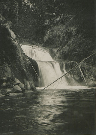
Ruskin is a rural, naturally-treed community, about 35 mi (56 km) east of Vancouver on the north shore of the Fraser River. It was named around 1900 after of the English art critic, essayist, and prominent social thinker John Ruskin.

McMillan Island is an island in the Fraser River, British Columbia, Canada, also known as McMillan Slough..

Fraser River Marine Transportation operated a ferry service, the Albion Ferry, in the Lower Mainland of British Columbia, Canada. The company was a wholly owned subsidiary of the South Coast British Columbia Transportation Authority (TransLink).

Whonnock is a rural, naturally treed, and hilly community on the north side of the Fraser River in the eastern part of the City of Maple Ridge, British Columbia, Canada. It is approximately 56 kilometres east of Downtown Vancouver on the Lougheed Highway Whonnock shares borders with three other Maple Ridge communities. To the west the borders are 256th Street with Albion and upper Kanaka Creek with Webster's Corners. To the east Whonnock Creek forms the border with Ruskin. To the north is the municipal border and to the south the Fraser River.

Haney, British Columbia is the name of the downtown core of the city of Maple Ridge, British Columbia. The name derived originally from Thomas Haney, the namesake of Port Haney, the neighbourhood adjoining today's downtown along the Fraser River immediately south, which is today includes a station on the West Coast Express and was formerly a steamboat port. Port Haney is a designated heritage district in Maple Ridge and includes buildings moved to the neighbourhood from other parts of the municipality that otherwise might have been demolished.

Kanaka Creek is an historic rural residential area located within Maple Ridge, British Columbia, Canada, along the banks of the creek of the same name just east of the district's main town and commercial core of Haney. Just east is Albion and immediately across the Fraser River is Derby or "Old Fort Langley", upstream from which and opposite Albion is Fort Langley. Kanaka Creek was settled by Hawaiian natives in the employ of the Hudson's Bay Company, known as Kanakas, often with local indigenous, usually Kwantlen, wives. Once a thriving community linked closely to the affairs of the fort, like the rancherie outside Fort Vancouver, Kanaka Creek dwindled somewhat when the fort was located further upstream, although some of the original families stayed on for decades. The area has long since been subdivided and is a suburban neighbourhood now, with Kanaka Creek Road, along the creek's west bank, the main arterial, which like the creek runs generally northeast, finally becoming 232nd Street to connect to the Dewdney Trunk Road. Upstream, to the northeast, is Kanaka Creek Regional Park and street connections to Webster's Corners and 240th Street. Although mostly suburban the neighbourhood retains a greenbelt quality because of the protection of the creek by its park and as a salmon spawning stream, and there are still farms operating in some parts of the area.

<span class="mw-page-title-main">Katzie First Nation</span> First Nation government in Canada

The Katzie First Nation or Katzie Nation is the band government of the Katzie people of the Lower Fraser Valley region of British Columbia, Canada.

<span class="mw-page-title-main">Kanaka Creek Regional Park</span> Regional park in British Columbia

Kanaka Creek Regional Park is a regional park of the Greater Vancouver Regional District, located in the city of Maple Ridge, British Columbia, flanking both sides of Kanaka Creek from its confluence with the Fraser River just east of Haney and extending approximately 11 km up the creek to just south of the community of Webster's Corners. The Maple Ridge Fairgrounds are just east of the lower regions of the park, beyond them is the community of Albion. Derby Reach Regional Park is just across the Fraser in Langley.

<span class="mw-page-title-main">Kanaka Creek</span> River in British Columbia, Canada

Kanaka Creek is a tributary of the Fraser River, in the Canadian province of British Columbia. It flows through Maple Ridge, a district municipality at the eastern edge of Metro Vancouver.

Port Hammond, commonly known as Hammond, is a community on the Fraser River within the city of Maple Ridge, British Columbia, Canada, near its border with the City of Pitt Meadows and just east of the Golden Ears Bridge.

Glover Road is a primary road in Langley, British Columbia which runs from southwest to northeast North-South from the Fraser Highway in downtown Langley to the Fraser River in Fort Langley, travelling over British Columbia Highway 1 and through the community of Milner, British Columbia. The road is 11 km (7 mi) in length and mostly two lanes wide with some divided four lane sections. It is notable as the primary road in and to the village of Fort Langley and as being concurrent for some of its length with British Columbia Highway 10. Beyond Fort Langley, it crosses the Jacob Haldi Bridge onto McMillan Island and terminates at the decommissioned Albion Ferry dock within the lands of the Kwantlen First Nation. The Glover Road overpass is a six-span, two-lane structure permitting access across Trans-Canada Highway. The underpass received an overheight-warning system, the second in the province, following damage from three collisions in three years.

References

  1. The "vinyl monster" (a reference to the exterior finish of most of these homes) Claus Andrup, Ghost Busters 2005, Radio Haney (webpage) accessed 4 December 2010
  2. Maple Ridge Museum and Archives, "Albion" Archived 2011-07-27 at the Wayback Machine , accessed 4 December 2010
  3. Maple Ridge Museum and Archives, "Albion" Archived 2011-07-27 at the Wayback Machine , accessed 4 December 2010
  4. Maple Ridge Museum, "Baker Road", ""A History of Street Names in Maple Ridge"" Archived 2011-10-07 at the Wayback Machine , accessed 4 December 2010
  5. "Albion". BC Geographical Names .
  6. BCGNIS entry "Langley Indian Reserve No. 5 [ permanent dead link ]
  7. Gladys Suttcliffe, quoted in Sheila Nickols, "Albion Hall a valuable place to meet" [ permanent dead link ], Maple Ridge News, 8 December 2010, accessed 9 December 2010
  8. "Albion Ferry to Cease Operation". Translink. Archived from the original on 2009-12-13. Retrieved 2010-01-16.
  9. Matthew Claxton, "Ferries being sold as scrap" Archived 2011-07-14 at the Wayback Machine , Maple Ridge Pitt Meadows Times, October 2010, accessed 9 December 2010
  10. Maple Ridge Parks, Albion Fairgrounds Archived 2010-12-18 at the Wayback Machine accessed 4 December 2010
  11. Maple Ridge Country Fest accessed 4 December 2010
  12. Maple Ridge Parks, Albion Park Archived 2010-12-18 at the Wayback Machine accessed 4 December 2010
  13. Troy Landreville, "Hill House has reluctant sellers" Archived 2011-07-14 at the Wayback Machine , Maple Ridge Times, May 2010, accessed 10 December 2010
  14. Phil Melnychuk, "Jackson Farm is now a park", The News, Dec 22, 2010, pp.1,3. Also found at www.mapleridgenews.com
  15. Claus Andrup, Ghost Busters 2005
  16. District of Maple Ridge, "Council Approves Albion Flats Concept Plan Process Archived 2010-12-17 at the Wayback Machine , 1 April 2010 accessed 4 December 2010
  17. Maple Ridge News, "Everything's Possible In Albion" Archived 2010-11-23 at the Wayback Machine , 18 November 2010, accessed 4 December 2010
  18. Phil Melnychuk, "SmartCentres has new plan for Albion" Archived 2010-12-16 at the Wayback Machine , Maple Ridge News, 9 December 2010, accessed 9 December 2010

49°11′00″N122°33′00″W / 49.18333°N 122.55000°W / 49.18333; -122.55000