Related Research Articles

Birmingham is a city in Oakland County in the U.S. state of Michigan. It is a northern suburb of Detroit located along the Woodward Corridor (M-1). As of the 2010 census, the population was 20,103.

Maple Valley is a city in King County, Washington, United States. The population was 28,013 at the 2020 census. The city functions as a commuter town for residents, though there is an increasing amount of commercial activity in the area.

South Hill is a census-designated place (CDP) in Pierce County, Washington, immediately south of Puyallup. The population was 64,708 at time of the 2020 census, up from 52,431 in 2010. The area primarily consists of suburban housing and shopping with several retail shopping centers, residential neighborhoods, and apartment/condo complexes throughout. Because South Hill is unincorporated, its addresses are part of the Puyallup "postal city" or ZCTA.

Thornhill is a suburban district in the Regional Municipality of York in Ontario, Canada. The western portion of Thornhill is within the City of Vaughan and its eastern portion is within the City of Markham, with Yonge Street forming the boundary between Vaughan and Markham. Thornhill is situated along the northern border of Toronto, centred on Yonge, and is also immediately south of the City of Richmond Hill. Once a police village, Thornhill is still a postal designation. As of 2016, its total population, including both its Vaughan and Markham sections, was 112,719.

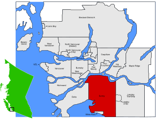
Maple Ridge is a city in British Columbia, Canada. It is located in the northeastern section of Greater Vancouver between the Fraser River and the Golden Ears, which is a group of mountain summits which are the southernmost of the Garibaldi Ranges of the Coast Mountains. Maple Ridge's population in 2021 was 90,990. Its downtown core area was once known as Haney.
Pitt Meadows is a municipality within Metro Vancouver in southwestern British Columbia, Canada. Incorporated in 1914, it currently has a land area of 86.34 square kilometres (33.34 sq mi) with a population of 19,146 as of 2021. The municipality received its name from the Pitt River and Pitt Lake. Pitt Meadows is one of 21 municipalities including Electoral Area A that comprises the Metro Vancouver Regional District.

Spryfield is community within the urban area of Halifax, Nova Scotia, Canada.

South Riding is a census-designated place and planned community in Loudoun County, Virginia, United States. The South Riding homeowner association was founded in January 1995 to provide services to the community. Neighboring U.S. Route 50 and State Route 28 provide access to the Dulles/Reston/Tysons Corner technology corridor and other major employment centers in Northern Virginia and Washington, D.C.
Ruskin is a rural, naturally-treed community, about 35 mi (56 km) east of Vancouver on the north shore of the Fraser River. It was named around 1900 after of the English art critic, essayist, and prominent social thinker John Ruskin.
West Friendship is a semi-rural unincorporated community in western Howard County, Maryland, United States. West Friendship is located at the junction of Interstate 70 and Maryland Route 32. Frederick Road is a main thoroughfare.
Lutherville is a census-designated place (CDP) in Baltimore County, Maryland, United States. As of the 2010 census it had a population of 6,504. Prior to 2010 the area was part of the Lutherville-Timonium CDP. Within its borders lies the Lutherville Historic District.
Albion, British Columbia is a neighbourhood in Maple Ridge, British Columbia and is one of several small towns incorporated within the municipality at its creation. It is the oldest non-indigenous community of the district's settlements, and is only slightly younger than Fort Langley, adjacent across the Fraser River, and Kanaka Creek, which is just to the west and lies along the creek of the same name. Its official definition is the area bounded by the Fraser River, Kanaka Way, and 240th Street, but in its historic sense it means the community centred on and flanking 240th Street and adjoining areas along the Fraser River waterfront and around the Maple Ridge Fairgrounds, while along Kanaka Way and also on the near bank of Kanaka Creek, the creek, is historically the community of Kanaka Creek. Burgeoning newer home construction east of 240th Street near the Lougheed Highway is also often referred to as part of Albion.

Murrayville is a small community in the Township of Langley in the Lower Mainland region of British Columbia, Canada.
Whonnock is a rural, naturally treed, and hilly community on the north side of the Fraser River in the eastern part of the City of Maple Ridge, British Columbia, Canada. It is approximately 56 kilometres east of Downtown Vancouver on the Lougheed Highway Whonnock shares borders with three other Maple Ridge communities. To the west the borders are 256th Street with Albion and upper Kanaka Creek with Webster's Corners. To the east Whonnock Creek forms the border with Ruskin. To the north is the municipal border and to the south the Fraser River.
Haney, British Columbia is the name of the downtown core of the city of Maple Ridge, British Columbia. The name derived originally from Thomas Haney, the namesake of Port Haney, the neighbourhood adjoining today's downtown along the Fraser River immediately south, which is today includes a station on the West Coast Express and was formerly a steamboat port. Port Haney is a designated heritage district in Maple Ridge and includes buildings moved to the neighbourhood from other parts of the municipality that otherwise might have been demolished.
Bradner is a community within the City of Abbotsford, British Columbia, Canada, located in a rural northwest region of that city which also includes Mount Lehman. Bradner occupies a height of land above the Fraser River, immediately across which is the community of Silverdale, a part of the District of Mission, and Ruskin, on the border between Mission and Maple Ridge. On the floodplain below to the west is the Langley rural neighbourhood of Glen Valley, while on the floodplain to the east, which is called Matsqui Prairie, the nearest Abbotsford neighbourhood is Matsqui Village. Bradner was formerly part of the District of Matsqui, which in 1995 was amalgamated into the City of Abbotsford.

The Katzie First Nation or Katzie Nation is the band government of the Katzie people of the Lower Fraser Valley region of British Columbia, Canada.
Port Hammond, commonly known as Hammond, is a community on the Fraser River within the city of Maple Ridge, British Columbia, Canada, near its border with the City of Pitt Meadows and just east of the Golden Ears Bridge.
Sunnyside is a neighbourhood of South Surrey, which in turn is a region of Surrey, British Columbia, Canada.

Fern Ridge is a neighbourhood of Langley, British Columbia. It is located in the southwestern area of Langley Township, near Campbell Valley Regional Park. 200th Street, or Carvolth Road, runs south through Fern Ridge, and TransLink provides hourly bus service during daylight hours to Langley City. There is one church in the community, a Mennonite church.
References
49°10′59″N122°30′14″W / 49.183°N 122.504°W
| | This Metro Vancouver-related article is a stub. You can help Wikipedia by expanding it. |