Yuquot

Last updated • 4 min readFrom Wikipedia, The Free Encyclopedia

Yuquot
Friendly Cove
Friendly Cove (7462038618).jpg
Nootka Lighthouse overlooking Yuquot
Location Nootka Island, British Columbia, Canada
Coordinates 49°36′N126°37′W / 49.600°N 126.617°W / 49.600; -126.617
Governing body Mowachaht/Muchalaht First Nations
Website https://www.yuquot.ca/
Official name Yuquot National Historic Site of Canada
Designated1923-05-25
Canada Vancouver Island location map.svg
Red pog.svg
Location of Yuquot in Vancouver Island
Canada British Columbia location map 2.svg
Red pog.svg
Yuquot (British Columbia)

Yuquot /ˈjkwɔːt/ , also known as Friendly Cove, is a small settlement of around six people—the Williams family of the Mowachaht band—plus two full-time lighthouse keepers, located on Nootka Island in Nootka Sound, just west of Vancouver Island, British Columbia, Canada. It was the summer home of Chief Maquinna and the Mowachaht/Muchalaht (Nuu-chah-nulth) people for generations, housing approximately 1,500 people in 20 traditional wooden longhouses. The name means "Wind comes from all directions" in Nuu-chah-nulth.

Contents

The community is located within the Strathcona Regional District but like all Indian Reserve communities is not governed by nor represented in the regional district. The Mowchaht/Muchalaht First Nations are rather part of the Nuu-chah-nulth Tribal Council, which unites the governments of the indigenous communities of the Island's West Coast.

The Canadian government declared Friendly Cove a National Historic Site in 1923, with recognition of the significance of the Spanish colonial settlement that was once there and First Nations history following in 1997.

History

The meaning of the name Yuquot is “where the winds blow from many directions”. It has been dubbed "the birthplace of British Columbia". [1]

Early exploration and settlement

Three Nuu-chah-nulth children in Yuquot, 1930s Nuu-chah-nulth children in Friendly Cove.jpg
Three Nuu-chah-nulth children in Yuquot, 1930s

Yuquot had been occupied for over 4,300 years by First Nations peoples of the Nootka Sound region. In the late 18th century, Nootka Sound became an important site of early contact between First Nations of the Pacific Northwest and European explorers, and developed into a centre of maritime fur trade. [2]

In 1774, Spanish explorer Juan José Pérez Hernández became the first European to spot Yuquot. The region was formally claimed as part of the Spanish Empire in a subsequent voyage by Spanish-Basque explorer Bruno de Heceta in 1775.

In 1778, the English Captain James Cook arrived at the bay on HMS Resolution, on his expedition in search of the North-West Passage. This marked the first recorded landing by Europeans, and a period of sustained contact between the Mowachaht people and these foreigners ensued for a while. [1]

On 5 May 1789, Spanish navigator and explorer Esteban José Martínez established the settlement of Santa Cruz de Nuca. It was the first European colony in what is now British Columbia, the only Spanish settlement in what is now Canada, and the northernmost verified Spanish settlement in the Americas. The colony was protected by the cannon of Fort San Miguel and was maintained until the resolution of the Nootka Crisis in 1795.

Nootka Crisis

Yuquot was the scene of the Nootka Crisis, which nearly led to war between Spain and Britain. Negotiations in Europe calmed the situation and led to the first Nootka Convention. Each nation sent a commissioner to Nootka Sound in order to carry out the terms of the Nootka Convention and related diplomatic issues. Arriving in 1792, George Vancouver was commissioner for Britain and Juan Francisco de la Bodega y Quadra for Spain. Quadra also served as the commandant of the Spanish settlement at Yuquot, hosting Vancouver and his crew. Quadra and Vancouver had to engage in diplomatic negotiations due to the Nootka Convention's vagueness and lack of detail over how it was to be implemented. In addition both commissioners had been given incomplete, differing, and confused instructions by their governments. They negotiated for months but in the end failed to reach an agreement. The matter was sent back to the British and Spanish governments.

The primary problem was a differing interpretation of the Nootka Convention. Vancouver's position, as instructed, was that the entire Spanish settlement was to be turned over to him. Quadra's position was that there was nothing left to turn over in accord with the Nootka Convention, but he made various offers, such as turning over a small cove in Nootka Sound, where John Meares had built the North West America in 1788, or turning over the entire settlement in exchange if Britain agreed to set the boundary between Spanish and British territory at the Strait of Juan de Fuca. Chief Maquinna played a role in the negotiations, identifying the cove where Meares had built his vessel, swearing that no land had ever been sold to the British and that the Spanish were the rightful occupants at Yuquotand that only on the condition that the site be restored to his people as soon as possible. Unable to reach an agreement, Vancouver and Quadra left in late 1792 and the settlement at Yuquot remained under Spanish control until 1795, when the terms of the third Nootka Convention, calling for the "mutual abandonment" of Nootka, were carried out, after which the site was reoccupied by the Maquinna and the Mowachaht people.

19th century

John R. Jewitt, an English blacksmith, was held there for three years 1803-1805 as Maquinna's slave, following the capture of the trading ship Boston and the murder of the captain and all but one other crew members. Jewitt's memoirs form an important record of Yuquot at that period.

20th century

In 1911, the government of Canada erected the Nootka Lighthouse atop San Rafael Island, a small rocky island that overlooks Yuquot and forms part of its natural harbour. The original lighthouse was later replaced with the current lighthouse in 1958. It serves as a navigational aid to vessels transiting Nootka Sound. [2]

21st century

Recently, the lighthouse has been home to a seasonal Canadian Coast Guard Inshore Rescue Boat station with a crew of three (two deckhands and a coxswain) and an 8-metre (26 ft) fast rescue craft at their disposal. [3]

See also

Related Research Articles

<span class="mw-page-title-main">Nuu-chah-nulth</span> North American ethnic group

The Nuu-chah-nulth, also formerly referred to as the Nootka, Nutka, Aht, Nuuchahnulth or Tahkaht, are one of the Indigenous peoples of the Pacific Northwest Coast in Canada. The term Nuu-chah-nulth is used to describe fifteen related tribes whose traditional home is on the west coast of Vancouver Island.

<span class="mw-page-title-main">John Meares</span> British navigator, explorer and fur trader (c. 1756 – 1809)

John Meares was an English navigator, explorer, and maritime fur trader, best known for his role in the Nootka Crisis, which brought Britain and Spain to the brink of war.

<span class="mw-page-title-main">Nootka Island</span> Island in Canada

Nootka Island is an island adjacent to Vancouver Island in British Columbia, Canada. It is 510 square kilometres (200 sq mi) in area. It is separated from Vancouver Island by Nootka Sound and its side-inlets, and is located within Electoral Area A of the Strathcona Regional District.

<span class="mw-page-title-main">Nootka Sound</span> Sound on the west coast of Vancouver Island in British Columbia, Canada

Nootka Sound is a sound of the Pacific Ocean on the rugged west coast of Vancouver Island, in the Pacific Northwest, historically known as King George's Sound. It separates Vancouver Island and Nootka Island, part of the Canadian province of British Columbia. It played a historically important role in the maritime fur trade.

<span class="mw-page-title-main">Robert Gray (sea captain)</span> American Merchant Sea Captain (1755–1806)

Robert Gray was an American Merchant Sea Captain who is known for his achievements in connection with two trading voyages to the northern Pacific coast of North America, between 1790 and 1793, which pioneered the American maritime fur trade in that region. In the course of those voyages, Gray explored portions of that coast and in the year 1790 he completed the first American circumnavigation of the world. He was also noted for coming upon and naming the Columbia River, in 1792, while on his second voyage.

<span class="mw-page-title-main">Tahsis</span> Village in British Columbia, Canada

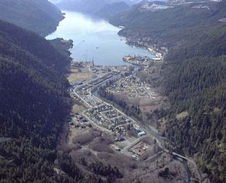
Tahsis is a village municipality on the west coast of Vancouver Island, British Columbia, Canada, about 300 km (186 mi) northwest of the provincial capital Victoria at 49°55′33″N126°37′16″W. As of 2011, the Canadian census listed 316 residents, a decline from the 2006 Census count of 366 residents. The Village of Tahsis economy used to be dependent on forestry, but after the closure of the local sawmill in 2001, the economy became heavily dependent on sport fishing for salmon and halibut, outdoor recreation and tourism.

<span class="mw-page-title-main">Maquinna</span>

Maquinna was the chief of the Nuu-chah-nulth people of Nootka Sound, during the heyday of the maritime fur trade in the 1780s and 1790s on the Pacific Northwest Coast. The name means "possessor of pebbles". His people are today known as the Mowachaht and reside today with their kin, the Muchalaht, at Gold River, British Columbia, Canada.

Nuu-chah-nulth, a.k.a.Nootka, is a Wakashan language in the Pacific Northwest of North America on the west coast of Vancouver Island, from Barkley Sound to Quatsino Sound in British Columbia by the Nuu-chah-nulth peoples. Nuu-chah-nulth is a Southern Wakashan language related to Nitinaht and Makah.

The Mowachaht/Muchalaht First Nations are a First Nations government on the west coast of Vancouver Island in the Canadian province of British Columbia. The Mowachaht/Muchalaht First Nations are a member nation of the Nuu-chah-nulth Tribal Council, which spans all Nuu-chah-nulth-aht peoples except for the Pacheedaht First Nation.

Nootka may refer to:

The Nuu-chah-nulth Tribal Council is a First Nations Tribal Council in the Canadian province of British Columbia, located on the west coast of Vancouver Island. The organization is based in Port Alberni, British Columbia.

<span class="mw-page-title-main">Esteban José Martínez Fernández y Martínez de la Sierra</span> Spanish navigator and explorer

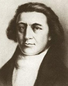
Esteban José Martínez Fernández y Martínez de la Sierra, or simply José Esteban Martínez (1742–1798) was a Spanish naval officer, navigator and explorer, native of Seville. He was a key figure in the Spanish exploration of the Pacific Northwest and the Nootka Crisis.

<span class="mw-page-title-main">Fort San Miguel</span> 1789–1795 Spanish fort in Vancouver Island, Canada

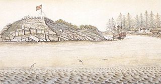
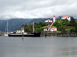
Fort San Miguel was a Spanish fortification at Yuquot on Nootka Island, just west of north-central Vancouver Island. It protected the Spanish settlement, called Santa Cruz de Nuca, the first colony in British Columbia.

<span class="mw-page-title-main">Nootka Crisis</span> Naval confrontation between the United States, Great Britain and Spain near Vancouver Island

The Nootka Crisis, also known as the Spanish Armament, was an international incident and political dispute between the Nuu-chah-nulth Nation, Spain, the Kingdom of Great Britain, and the fledgling United States of America triggered by a series of events revolving around sovereignty claims and rights of navigation and trade. It took place during the summer of 1789 at the Spanish outpost Santa Cruz de Nuca, in Nootka Sound on Vancouver Island in present-day British Columbia, Canada. The commander of the outpost, Jose Esteban Martínez, seized some British commercial ships which had come for the maritime fur trade and to build a permanent post at Nootka Sound. Public outcry in Great Britain led to the mobilization of the Royal Navy, and the possibility of war. Both sides called upon allies, the Dutch joined the side of Great Britain; Spain mobilized her navy and her key ally France also mobilized theirs, but the latter soon announced they would not go to war. Without French help, Spain had little hope against the British and the Dutch, resulting in Spain seeking a diplomatic solution and making concessions.

Princess Royal was a British merchant ship that sailed on fur trading ventures in the late 1780s, and was captured at Nootka Sound by Esteban José Martínez of Spain during the Nootka Crisis of 1789. Called Princesa Real while under the Spanish Navy, the vessel was one of the important issues of negotiation during the first Nootka Convention and the difficulties in carrying out the agreements. The vessel also played an important role in both British and Spanish exploration of the Pacific Northwest and the Hawaiian Islands. In 1790, while under Spanish control, Princesa Real carried out the first detailed examination of the Strait of Juan de Fuca by non-indigenous peoples, finding, among other places, the San Juan Islands, Haro Strait, Esquimalt Harbour near present-day Victoria, British Columbia, and Admiralty Inlet.

<span class="mw-page-title-main">Opitsaht</span>

Opitsaht, spelled also as Opitsat and Opitsitah, is a Tla-o-qui-aht settlement/community in the Southwest area of the Meares Islands, Clayoquot South, British Columbia. This peninsula-like region is the home to the Tla-o-qui-aht people from the Nuu-chah-nulth nation, a tribe from the Pacific Northwest region in the lower Vancouver area, known for their lifestyle revolving around the marine life trade and culture within the community.

<span class="mw-page-title-main">Santa Cruz de Nuca</span> 1789–1795 Spanish settlement in Vancouver Island, Canada

Santa Cruz de Nuca was a Spanish colonial fort and settlement and the first European colony in what is now known as British Columbia. The settlement was founded on Vancouver Island in 1789 and abandoned in 1795, with its far northerly position making it the "high-water mark" of verified northerly Spanish settlement along the North American west coast. The colony was established with the Spanish aim of securing the entire west coast of the continent from Alaska southwards, for the Spanish crown.

<span class="mw-page-title-main">Yuquot Whalers' Shrine</span> Collection of carved figures previously serving as a Yuquot ritual site

The Yuquot Whalers' Shrine, previously located on Vancouver Island, British Columbia, was a site of purification rituals, passed down through the family of a Yuquot chief. It contained a collection of 88 carved human figures, four carved whale figures, and sixteen human skulls. Since the early twentieth century, it has been in the possession of the American Museum of Natural History in New York City, but is rarely displayed. Talks are underway regarding repatriation.

<span class="mw-page-title-main">James Charles Stuart Strange</span> British politician

James Charles Stuart Strange was a British officer of the East India Company, one of the first maritime fur traders, a banker, and a Member of Parliament.

<span class="mw-page-title-main">Whaling on the Pacific Northwest Coast</span>

Whaling on the Pacific Northwest Coast encompasses both aboriginal and commercial whaling from Washington State through British Columbia to Alaska. The indigenous peoples of the Pacific Northwest Coast have whaling traditions dating back millennia, and the hunting of cetaceans continues by Alaska Natives and to a lesser extent by the Makah people.

References

  1. 1 2 "Yuquot (Friendly Cove)". The Bill Reid Centre. Retrieved 15 March 2021.
  2. 1 2 "Nootka Lighthouse". www.pc.gc.ca. Retrieved 2020-07-29.
  3. Inshore Rescue Boat Station

Further reading