Related Research Articles

Vancouver Island is an island in the northeastern Pacific Ocean and part of the Canadian province of British Columbia. The island is 456 km (283 mi) in length, 100 km (62 mi) in width at its widest point, and 32,134 km2 (12,407 sq mi) in area. The island is the largest by area and the most populous along the west coasts of the Americas.
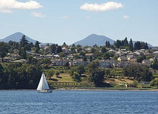
Ladysmith, originally Oyster Harbour, is a town located on the 49th parallel north on the east coast of Vancouver Island, British Columbia, Canada. The local economy is based on forestry, tourism, and agriculture. A hillside location adjacent to a sheltered harbour forms the natural geography of the community.
There are many roads in the southwestern part of British Columbia and Vancouver Island that were designated as Highway 1A. These roads were sections of the original 1941 route of Highway 1 before its various re-alignments, and are used today as service routes and frontage roads. The "B.C. Highway 1A" designations were removed from these sections by the province between 2005 and 2010, although signage remains along some of the route and the designation on some maps.

Duncan is a city on southern Vancouver Island in British Columbia, Canada. It is the smallest city by area in Canada. It was incorporated in 1912.
Crofton is a small west coast town within the District of North Cowichan of southern Vancouver Island in British Columbia, east of BC Highway 1 about 74 kilometres (46 mi) north of Victoria.

Chemainus is a community in the Chemainus Valley on the east coast of southern Vancouver Island, British Columbia, Canada.

North Cowichan is a district municipality established in 1873 on Vancouver Island, in British Columbia, Canada. The municipality is part of the Cowichan Valley Regional District. North Cowichan is noted for a landscape including forests, beaches, rivers, and lakes. The municipality encompasses the communities of Chemainus; Westholme; Crofton; Maple Bay; and "the South End". The latter is an informal name for a built-up area which is essentially a suburb of the City of Duncan, a separate municipality.

Cowichan Bay is a bay and community located on the east coast of southern Vancouver Island near Duncan, in British Columbia. The mouth of the Cowichan River is near Cowichan Bay. Mount Tzouhalem and its hiking trails and ecological reserve stands to the north. The bay is known for its fishing and scenic value. The area's main industries are fishing and tourism.
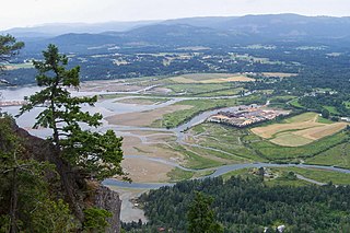
The Cowichan Valley is a region around the Cowichan River, Cowichan Bay and Cowichan Lake on Vancouver Island, in British Columbia, Canada. There is some debate as to the origin of the name Cowichan, which many believe to be an anglicized form of the First Nations tribal name Quw'utsun.
Saltair is an unincorporated community with a population of 2,069 on the east coast of Vancouver Island, British Columbia, Canada, or the Georgia Strait. It is a predominantly rural community located between the urban centers of Ladysmith and Chemainus. Saltair is within the Cowichan Valley Regional District. It is home to a number of parks: Stocking Creek Park, Diana, Princess of Wales Wilderness Park, and Saltair Centennial Park. In part, Saltair is a community of artists, scenery and farmland. It provides panoramic ocean and mountain views and a rural ambiance its residents treasure. Community news and updates can be found on Saltair websites. The area is served by the coast-spanning Island Highway and the Island Rail Corridor.

The Cowichan Valley Regional District is a regional district in the Canadian province of British Columbia is on the southern part of Vancouver Island, bordered by the Nanaimo and Alberni-Clayoquot Regional Districts to the north and northwest, and by the Capital Regional District to the south and east. As of the 2021 Census, the Regional District had a population of 89,013. The regional district offices are in Duncan.
The Comox Valley is a region on the east coast of Vancouver Island, British Columbia, Canada, that includes the city of Courtenay, the town of Comox, the village of Cumberland, and the unincorporated settlements of Royston, Union Bay, Fanny Bay, Black Creek, and Merville. The communities of Denman Island and Hornby Island are also considered part of the Comox Valley. The Comox Valley contains the 47th largest metropolitan area in Canada with a population of about 66,000 as of 2016.

The Cowichan River is a moderately sized river on Vancouver Island, in British Columbia, Canada. It originates in Cowichan Lake, flowing east towards its end at Cowichan Bay. Its drainage basin is 795 square kilometres (307 sq mi) in size.
Malahat is an unincorporated area in the Cowichan Valley, with municipal-type services delivered by the Cowichan Valley Regional District. What could be considered the hub of the community is a small collection of businesses that includes the Malahat Gas station and the Malahat Chalet and the Moon Water Lodge.

The Musqueam Indian Band is a First Nations band government in the Canadian province of British Columbia. It is the only First Nations band whose reserve community lies within the boundaries of the City of Vancouver.
Mount Sicker is in southern Vancouver Island, British Columbia. The twin summits of Big Sicker Mountain, at 716 metres (2,349 ft), and Little Sicker Mountain, at 660 metres (2,170 ft), are near Crofton, Chemainus and Duncan.

Koksilah Ridge (Hwsalu'utsum) is an elevated area located south of the Cowichan Valley on Vancouver Island, British Columbia. It is centered at 48°42′

Cowichan Tribes is the band government of the Cowichan, a group of Coast Salish peoples who live in the Cowichan Valley region on Vancouver Island. With over 3,800 registered members, it is the single largest First Nations band in British Columbia.
The Chemainus River is located on southern Vancouver Island, British Columbia, Canada. Its source is in the Vancouver Island Ranges, and it flows eastwards to the Strait of Georgia near the town of Chemainus, British Columbia. The valley that surrounds the river additionally includes the communities of Crofton and Westholme as well as the Halalt First Nation Reserve and several smaller reserves. Located on one of the largest islands at the mouth of the river, an old now-deserted village called Xulel-thw stands on the northeast corner; Coast Salish peoples lived there and in other now-deserted villages in the area, constantly moving throughout history.
Alistair Bruce MacGregor is a Canadian politician, who was elected to the House of Commons of Canada in the 2015 Canadian federal election to represent the electoral district of Cowichan—Malahat—Langford. He is a member of the New Democratic Party. During the 42nd Canadian Parliament, MacGregor sponsored three private member bills, though none reached second reading stage: Bill 252 to add Shawnigan Lake to the list of navigable waters regulated under the Navigation Protection Act, Bill C-279 to limit federal election campaigns to a maximum of 46 days, Bill C-430 to create an organic farming tax credit.
References
Coordinates: 48°52′N123°42′W / 48.867°N 123.700°W
| | This article about a location on the Coast of British Columbia, Canada is a stub. You can help Wikipedia by expanding it. |