Sea lane

Last updated

A sea lane, sea road or shipping lane is a regularly used navigable route for large water vessels (ships) on wide waterways such as oceans and large lakes, and is preferably safe, direct and economic. During the Age of Sail, they were determined by the distribution of land masses but also by the prevailing winds, whose discovery was crucial for the success of long maritime voyages. Sea lanes are very important for seaborne trade.

Contents

History

The westerlies and trade winds Map prevailing winds on earth.png
The westerlies and trade winds
The ocean currents Corrientes-oceanicas.png
The ocean currents

The establishment of the North Atlantic sea lanes was inspired by the sinking of the US mail steamer SS Arctic by collision with the French steamer SS Vesta in October 1854 which resulted in the loss of over 300 lives. Lieutenant M. F. Maury of the US Navy first published a section titled "Steam Lanes Across the Atlantic" in his 1855 Sailing Directions proposing sea lanes along the 42 degree latitude. A number of international conferences and committees were held in 1866, 1872, 1887, 1889, and 1891 all of which left the designation of sea lanes to the principal trans-Atlantic steamship companies at the time; Cunard, White Star, Inman, National Line, and Guion Lines. In 1913–1914 the International Convention for Safety of Life at Sea held in London again reaffirmed that the selection of routes across the Atlantic in both directions is left to the responsibility of the steamship companies. [1]

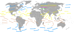
Shipping lanes came to be by analysing the prevailing winds. The trade winds allowed ships to sail towards the west quickly, and the westerlies allowed ships to travel to the east quickly. As such, the sea lanes are mostly chosen to take full advantage of these winds. Currents are also similarly followed as well, which also gives an advantage to the vessel.[ citation needed ] Some routes, such as that from Cape Town to Rio de Janeiro (passing Tristan da Cunha), were not able to take advantage of these natural factors.

Main sea lanes may also attract pirates.[ citation needed ] Pax Britannica was the period from 1815–1914 during which the British Royal Navy controlled most of the key maritime trade routes, and also suppressed piracy and the slave trade. During World War I, as German U-boats began hitting American and British shipping, the Allied trade vessels began to move out of the usual sea lanes to be escorted by naval ships.

Advantages

Behind the cardinal mark is a sea lane opened on an ice-covered sea. Cardinal mark (east) in ice in front of South Harbor Helsinki Finland.jpg
Behind the cardinal mark is a sea lane opened on an ice-covered sea.

Although most ships no longer use sails (having switched them for engines), the wind still creates waves, and this can cause heeling. As such following the overall direction of the trade winds and westerlies is still very useful. However, it is best for any vessel that is not engaged in trading, or is smaller than a certain length, to avoid the lanes. This is not only because the slight chance of a collision with a large ship that can easily cause a smaller ship to sink, but also because large vessels are much less maneuverable than smaller ships, and need much more depth. Smaller ships can thus easily take courses that are nearer to the shore. Unlike with road traffic, there is no exact "road" a ship must follow, so this can easily be done.

Shipping lanes are the busiest parts of the sea, thus being a useful place for stranded boaters whose boats are sinking or people on a liferaft to boat to, and be rescued by a passing ship.

Threats from shipping lanes

Shipping routes red black.png
16th century Portuguese Spanish trade routes.png
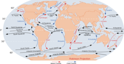
Left: This map of shipping routes illustrates the present-day density of commercial shipping in the world's oceans. Right: 16th century and current day trade routes prey to pirating and privateering.

Shipping lanes may pose threats to some ocean-going craft. Small boats risk conflicts with bigger ships if they follow the shipping lanes. Sections of lanes exist which can be shallow or have some kind of obstruction (such as sand banks). This threat is greatest when passing some narrows, such as between islands in the Indian Ocean (e.g. in Indonesia) as well as between islands in the Pacific (e.g. near the Marquesas islands, Tahiti) Some shipping lanes, such as the Straits of Malacca off Indonesia and Malaysia, and the waters off Somalia, are frequented by pirates operating independently or as privateers (for companies and countries). Passing ships run the risk of being attacked and held for ransom.

Busiest shipping lanes

The world's busiest shipping lane is the Dover Strait. 500–600 vessels per day traverse the narrow strait and in 1999 1.4 billion tonnes gross, carried by 62,500 vessels passed through the strait. [2]

See also

Related Research Articles

<span class="mw-page-title-main">Sailing</span> Propulsion of a vehicle by wind power

Sailing employs the wind—acting on sails, wingsails or kites—to propel a craft on the surface of the water, on ice (iceboat) or on land over a chosen course, which is often part of a larger plan of navigation.

<span class="mw-page-title-main">Strait of Malacca</span> Strait between the Malay Peninsula and the Indonesian island of Sumatra

The Strait of Malacca is a narrow stretch of water, 500 mi long and from 40 to 155 mi wide, between the Malay Peninsula to the northeast and the Indonesian island of Sumatra to the southwest, connecting the Andaman Sea and the South China Sea. As the main shipping channel between the Indian and Pacific oceans, it is one of the most important shipping lanes in the world. It is named after the Malacca Sultanate that ruled over the strait between 1400 and 1511, the center of administration of which was located in the modern-day state of Malacca, Malaysia.

<span class="mw-page-title-main">Steamship</span> Type of steam-powered vessel

A steamship, often referred to as a steamer, is a type of steam-powered vessel, typically ocean-faring and seaworthy, that is propelled by one or more steam engines that typically move (turn) propellers or paddlewheels. The first steamships came into practical usage during the early 1800s; however, there were exceptions that came before. Steamships usually use the prefix designations of "PS" for paddle steamer or "SS" for screw steamer. As paddle steamers became less common, "SS" is assumed by many to stand for "steamship". Ships powered by internal combustion engines use a prefix such as "MV" for motor vessel, so it is not correct to use "SS" for most modern vessels.

<span class="mw-page-title-main">Ocean liner</span> Ship designed to transport people from one seaport to another

An ocean liner is a type of passenger ship primarily used for transportation across seas or oceans. Ocean liners may also carry cargo or mail, and may sometimes be used for other purposes. Only one ocean liner remains in service today.

<span class="mw-page-title-main">Age of Sail</span> Historical era when sailing ships dominated global trade and warfare

The Age of Sail is a period that lasted at the latest from the mid-16th to the mid-19th centuries, in which the dominance of sailing ships in global trade and warfare culminated, particularly marked by the introduction of naval artillery, and ultimately reached its highest extent at the advent of the analogue Age of Steam. Enabled by the advances of the related Age of Navigation, it is identified as a distinctive element of the early modern period and the Age of Discovery. Especially in context of the latter, it refers to a more particular Eurocentric Age of Sail, while generally the Age of Sail is the culminating period of a long intercontinental history of sailing.

<span class="mw-page-title-main">Cargo ship</span> Ship or vessel that carries goods and materials

A cargo ship or freighter is a merchant ship that carries cargo, goods, and materials from one port to another. Thousands of cargo carriers ply the world's seas and oceans each year, handling the bulk of international trade. Cargo ships are usually specially designed for the task, often being equipped with cranes and other mechanisms to load and unload, and come in all sizes. Today, they are almost always built of welded steel, and with some exceptions generally have a life expectancy of 25 to 30 years before being scrapped.

<span class="mw-page-title-main">Tramp trade</span> Cargo shipping without a fixed schedule

A boat or ship engaged in the tramp trade is one which does not have a fixed schedule, itinerary nor published ports of call, and trades on the spot market as opposed to freight liners. A steamship engaged in the tramp trade is sometimes called a tramp steamer; similar terms, such as tramp freighter and tramper, are also used. Chartering is done chiefly on London, New York, and Singapore shipbroking exchanges. The Baltic Exchange serves as a type of stock market index for the trade.

<span class="mw-page-title-main">Choke point</span> Critical pathway through land or water, through which an armed force must pass

In military strategy, a choke point is a geographical feature on land such as a valley, defile or bridge, or maritime passage through a critical waterway such as a strait, which an armed force is forced to pass through in order to reach its objective, sometimes on a substantially narrowed front and therefore greatly decreasing its combat effectiveness by making it harder to bring superior numbers to bear. A choke point can allow a numerically inferior defending force to use the terrain as a force multiplier to thwart or ambush a much larger opponent, as the attacker cannot advance any further without first securing passage through the choke point.

<span title="Portuguese-language text"><i lang="pt">Volta do mar</i></span> Archaic navigational technique

Volta do mar, volta do mar largo, or volta do largo is a navigational technique perfected by Portuguese navigators during the Age of Discovery in the late fifteenth century, using the dependable phenomenon of the great permanent wind circle, the North Atlantic Gyre. This was a major step in the history of navigation, when an understanding of winds in the age of sail was crucial to success: the European sea empires would not have been established without an understanding of the trade winds.

<span class="mw-page-title-main">Maritime history</span> Study of human activity at sea

Maritime history is the study of human interaction with and activity at sea. It covers a broad thematic element of history that often uses a global approach, although national and regional histories remain predominant. As an academic subject, it often crosses the boundaries of standard disciplines, focusing on understanding humankind's various relationships to the oceans, seas, and major waterways of the globe. Nautical history records and interprets past events involving ships, shipping, navigation, and seafarers.

<span class="mw-page-title-main">Maritime history of California</span> Aspect of history

The maritime history of California can be divided into several periods: the Native American period; European exploration period from 1542 to 1769; the Spanish colonial period, 1769 to 1821; the Mexican period, 1821 to 1847; and United States statehood period, which continues to the present day. In the history of the California coast, the use of ships and the Pacific Ocean has historically included water craft, fisheries, shipbuilding, Gold Rush shipping, ports, shipwrecks, naval ships and installations, and lighthouses.

<span class="mw-page-title-main">Clipper route</span> Sailing route around the world

The clipper route was the traditional route derived from the Brouwer Route and sailed by clipper ships between Europe and the Far East, Australia and New Zealand. The route ran from west to east through the Southern Ocean, to make use of the strong westerly winds of the Roaring Forties. Many ships and sailors were lost in the heavy conditions along the route, particularly at Cape Horn, which the clippers had to round on their return to Europe.

<span class="mw-page-title-main">Cape Horn</span> Headland of the Tierra del Fuego archipelago located in Chile

<span class="mw-page-title-main">Great Tea Race of 1866</span> Sailing ship race from China to London

In the middle third of the 19th century, the clippers which carried cargoes of tea from China to Britain would compete in informal races to be first ship to dock in London with the new crop of each season. The Great Tea Race of 1866 was keenly followed in the press, with an extremely close finish. Taeping docked 28 minutes before Ariel - after a passage of more than 14,000 miles. Ariel had been ahead when the ships were taken in tow by steam tugs off Deal, but after waiting for the tide at Gravesend the deciding factor was the height of tide at which one could enter the different docks used by each ship. The third finisher, Serica, docked an hour and 15 minutes after Ariel. These three ships had left China on the same tide and arrived at London 99 days later to dock on the same tide. The next to arrive, 28 hours later, was Fiery Cross, followed, the next day, by Taitsing.

<i>Sechelt</i> (steamboat)

Sechelt was an American steamship which operated from 1893 to 1911 on Lake Washington, Puget Sound and the Strait of Georgia, mostly as a passenger ferry with routes between Washington state and British Columbia. For most of her career, she was called Hattie Hansen. She became well known following her unexplained sinking with no survivors near Race Rocks Lighthouse in 1911.

<span class="mw-page-title-main">Packet boat</span> Medium-sized boat designed for domestic mail, passenger, and freight transportation

Packet boats were medium-sized boats designed for domestic mail, passenger, and freight transportation in European countries and in North American rivers and canals, some of them steam driven. They were used extensively during the 18th and 19th centuries and featured regularly scheduled service.

<i>Lahloo</i> (clipper)

Lahloo was a British tea clipper known for winning the Tea Race of 1870, and finishing second in the Tea Race of 1871. She sailed from Fuzhou to London with over a million pounds of tea in 1868.

Henry Ramey Upcher Historic lifeboat in Norfolk

Henry Ramey Upcher was the second private lifeboat to be stationed in the English town of Sheringham in the county of Norfolk. She was launched on 4 September 1894 and stayed on station for 41 years until she was slowly retired from duty and by 1935 had ceased rescue work completely. The lifeboat is now on permanent display in her converted original boat shed.

<span class="mw-page-title-main">Cape Route</span> Shipping route around the Cape of Good Hope

The European-Asian sea route, commonly known as the sea route to India or the Cape Route, is a shipping route from the European coast of the Atlantic Ocean to Asia's coast of the Indian Ocean passing by the Cape of Good Hope and Cape Agulhas at the southern edge of Africa. The first recorded completion of the route was made in 1498 by Portuguese explorer Vasco da Gama, the admiral of the first Portuguese Armadas bound eastwards to make the discovery. The route was important during the Age of Sail, but became partly obsolete as the Suez Canal opened in 1869.

This glossary of nautical terms is an alphabetical listing of terms and expressions connected with ships, shipping, seamanship and navigation on water. Some remain current, while many date from the 17th to 19th centuries. The word nautical derives from the Latin nauticus, from Greek nautikos, from nautēs: "sailor", from naus: "ship".

References

  1. Encyclopædia Britannica, Fourteenth Edition, Volume 20 pp. 539, 1938
  2. "Busiest shipping lane". Guinness World Records. Archived from the original on 2015-05-03. Retrieved 2018-12-11.