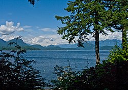
Keats Island (British Columbia)

Last updated

Keats Island
Keats Island from water.jpg
Keats Island (centre) from the BC Ferry
Coordinates: 49°24′N123°27′W / 49.400°N 123.450°W / 49.400; -123.450
CountryCanada
Province British Columbia
Region Howe Sound
Area
  Total6 km2 (2.3 sq mi)
  Land6 km2 (2.3 sq mi)
Elevation
242 m (795 ft)
Time zone UTC−8 (PST)
  Summer (DST) UTC−7 (PDT)
Area code(s) 604, 778
Keats Island from the north. Keats-Island-from-the-north.jpg
Keats Island from the north.
The view north from Keats Island, including Gambier island. North-from-Keats-Island.jpg
The view north from Keats Island, including Gambier island.

Keats Island is an inhabited island located in Howe Sound near Vancouver, British Columbia. Around eighty people live on Keats Island year-round.

Contents

Physical geography, settlements and climate

Keats Island is one of the larger islands in Howe Sound, located offshore from the community of Gibsons on the Sunshine Coast and directly west of Bowen Island. The island is part of West Howe Sound, Electoral Area F within the Sunshine Coast Regional District (SCRD) in British Columbia, Canada.

Other than a few cleared fields, the entire island is covered in forest. There are several beaches scattered around the island, and a prominent rocky outcrop called Salmon Rock at the Southwest tip.

Name

Keats Island's indigenous name is Lheḵ’tínes. [1]

Like many of the features in Howe Sound, Keats Island was named by George Henry Richards, who surveyed the British Columbia Coast from 1857 to 1862, first in HMS Plumper (which is commemorated by the name of Plumper Cove) until 1861, and then in HMS Hecate. Keats Island is named after Sir Richard Goodwin Keats, a British Admiral. Admiral Keats served under Horatio Nelson, 1st Viscount Nelson and was famous for sailing HMS Superb through a blockade at Gibraltar in 1801 during the Napoleonic wars. In 1813 Admiral Keats was also a governor of the Island of Newfoundland. Keats Island is the only large island in Howe Sound named for an officer who did not take part in the Battle of Trafalgar, as his ship was undergoing refit at the time. However, he had already established his fame in the Second Battle of Algeciras.

Settlement and services

Residential development on Keats Island is mostly summer cabins, with about 40 full-time residents. Most residents shop and obtain other services in Gibsons, the nearest town of any size.

The communities on Keats Island are clustered around the two government wharves: Keats Landing on the west coast, facing Gibsons and having a view of Shoal Channel separating the island from the mainland, and the larger community of Eastbourne located on the southeast shore. In addition, Plumper Cove extends along the west shore of the island from Freeman's Bluff (just north of the government wharf at Keats Landing) to Plumper Cove Marine Provincial Park, and Melody Point is on the northwest tip of the island, facing Langdale on the mainland.

Keats Camps is a Baptist summer camp, founded in 1926 on the site of a former orchard, operated on 93 hectares of land on the west part of the island. Keats Landing grew up around the camp, on lots leased from the Baptist Convention of British Columbia. Because the majority of the island's summer visitors are Christians, Keats Camps hosts public churches on Sundays for the whole island and the campers of Keats Camps.

Barnabas Family Ministries is a Christian camp and retreat centre operated on 64 hectares on the north side of the island. This land was formerly owned by the Corkum family, and was referred to as "Corky's Farm". It is now owned by Barnabas.

Access

Visitors to Keats Island can take a BC Ferry vessel from Horseshoe Bay north of Vancouver to Langdale Ferry Terminal on the Sunshine Coast. Keats Island and nearby Gambier Island are served by foot passenger ferry from the ferry terminal at Langdale, and Keats is accessible by water taxi from Gibsons and Horseshoe Bay. For years, Keats was served from Langdale by the ferry Dogwood Princess and is now served by the ferry Stormaway. Visitors may also drive from Langdale to Gibsons and take a water taxi to Keats Landing.

There are a few rough roads connecting locations on the island, but there is very little vehicle use. Most of the residential properties are accessible only from the water.

Amenities

Plumper Cove Marine Provincial Park, one of the oldest marine parks in BC, is a popular overnight destination for boats from nearby Gibsons and Vancouver.

Related Research Articles

<span class="mw-page-title-main">Bowen Island</span> Island municipality in British Columbia, Canada

Bowen Island, British Columbia, is an island municipality that is part of Metro Vancouver, and within the jurisdiction of the Islands Trust. Located in Howe Sound, it is approximately 6 kilometres (3.7 mi) wide by 12 kilometres (7.5 mi) long, and at its closest point is about 3 kilometres (1.9 mi) west of the mainland. There is regular ferry service from Horseshoe Bay provided by BC Ferries, and semi-regular water taxi services. The population of 4,256 is supplemented in the summer by about 1,500 visitors. It has a land area of 50.12 km2 (19.35 sq mi).

British Columbia Ferry Services Inc., operating as BC Ferries (BCF), is a former provincial Crown corporation, now operating as an independently managed, publicly owned Canadian company. BC Ferries provides all major passenger and vehicle ferry services for coastal and island communities in the Canadian province of British Columbia. Set up in 1960 to provide a similar service to that provided by the Black Ball Line and the Canadian Pacific Railway, which were affected by job action at the time, BC Ferries has become the largest passenger ferry line in North America, operating a fleet of 41 vessels with a total passenger and crew capacity of over 27,000, serving 47 locations on the B.C. coast.

<span class="mw-page-title-main">Pender Island</span> Island in British Columbia, Canada

Pender Island is one of the Southern Gulf Islands located in the Salish Sea, British Columbia, Canada. Pender Island is approximately 34 km2 (13 sq mi) in area and is home to about 2,250 permanent residents, as well as a large seasonal population. Like most of the rest of the Southern Gulf Islands, Pender Island enjoys a sub-Mediterranean climate and features open farmland, rolling forested hills, several lakes and small mountains, as well as many coves and beaches.

British Columbia Highway 101, also known as the Sunshine Coast Highway, is the main north–south thoroughfare on the Sunshine Coast, British Columbia, Canada.

<span class="mw-page-title-main">Sunshine Coast (British Columbia)</span> Subregion of British Columbia in Canada

The Sunshine Coast is a geographic subregion of the British Columbia Coast that generally comprises the regional districts of qathet and Sunshine Coast.

<span class="mw-page-title-main">Sunshine Coast Regional District</span> Regional district in British Columbia, Canada

The Sunshine Coast Regional District is a regional district in British Columbia, Canada. It is located on the southern mainland coast, across Georgia Strait from Vancouver Island. It borders on the qathet Regional District to the north, the Squamish-Lillooet Regional District to the east, and, across Howe Sound, the Metro Vancouver District to the south. The regional district offices are located in the District Municipality of Sechelt.

<span class="mw-page-title-main">Earls Cove, British Columbia</span> Locality in British Columbia, Canada

Earls Cove is a small settlement located on Jervis Inlet in the Sunshine Coast region of British Columbia. It is a terminal for the BC Ferries route across the inlet to Saltery Bay, linking the Lower Sunshine Coast with the Upper Sunshine Coast. Earls Cove is at the north end of the Sechelt Peninsula and on the east side of the mouth of Jervis Inlet, adjacent to Agamemnon Channel, across which is Nelson Island.

<span class="mw-page-title-main">Howe Sound</span> Sound in Canada

Howe Sound is a roughly triangular sound, that joins a network of fjords situated immediately northwest of Vancouver, British Columbia, Canada. It was designated as a UNESCO Biosphere Reserve in 2021.

<span class="mw-page-title-main">Jervis Inlet</span> Inlet in British Columbia, Canada

Jervis Inlet is one of the principal inlets of the British Columbia Coast, about 95 km (59 mi) northwest of Vancouver, and the third of such inlets north of the 49th parallel, the first of which is Burrard Inlet, Vancouver's harbour.

<span class="mw-page-title-main">Plumper Cove Marine Provincial Park</span> Provincial park in British Columbia

Plumper Cove Marine Provincial Park is a provincial park in British Columbia, Canada. The park is located on Keats Island in Howe Sound, northwest of Vancouver, British Columbia.

HMS <i>Plumper</i> (1848) Sloop of the Royal Navy

HMS Plumper was part of the 1847 programme, she was ordered on the 25 of April as a steam schooner from Woolwich Dockyard with the name Pincher. However, the reference Ships of the Royal Navy, by J.J. College, (c) 2020 there is no entry that associates this name to this build. The vessel was reordered on August 12 as an 8-gun sloop as designed by John Fincham, Master Shipwright at Portsmouth. Launched in 1848, she served three commissions, firstly on the West Indies and North American Station, then on the West Africa Station and finally in the Pacific Station. It was during her last commission as a survey ship that she left her most enduring legacy; in charting the west coast of British Columbia she left her name and those of her ship's company scattered across the charts of the region. She paid off for the last time in 1861 and was finally sold for breaking up in 1865.

MV <i>Queen of Surrey</i>

MV Queen of Surrey is a double-ended C-class roll-on/roll-off ferry in the BC Ferries fleet. The ship was launched in 1980 and entered service in 1981. The ferry normally operates on BC Ferries' Horseshoe Bay to Langdale route. She is named for the city of Surrey. On May 12, 2003, Queen of Surrey suffered an engine fire that disabled the ferry in Howe Sound. No one was injured and the ship was returned to service. In 2004, the ferry was involved in a collision with a tugboat, and in 2019 she struck a fixed structure at the Langdale terminal. The 2019 crash lead to passengers being stranded on the vessel for over ten hours.

Gambier Island is an island located in Howe Sound near Vancouver, British Columbia. It is about 17,049 acres in size and is located about 10 kilometres north of the Horseshoe Bay community and ferry terminal in westernmost West Vancouver.

<span class="mw-page-title-main">Langdale, British Columbia</span> Unincorporated community in British Columbia, Canada

Langdale is a small residential community in British Columbia, Canada, located within the territory of the Squamish Nation, and part of West Howe Sound, Electoral Area F within the Sunshine Coast Regional District (SCRD).

<span class="mw-page-title-main">Bowyer Island</span> Island in British Columbia, Canada

Bowyer Island is a small private island in Howe Sound. It comprises Kildare Estates, Bowyer Island Estates, and B and A Estates. It is located east of Bowen Island and Horseshoe Bay. BC Liberal politician, formerly Attorney-General of British Columbia, Geoff Plant is a seasonal resident.

<span class="mw-page-title-main">Port Mellon</span> Place in British Columbia, Canada

Port Mellon is a settlement in British Columbia, Canada, located within the territory of the Squamish Nation, and part of West Howe Sound, Electoral Area F within the Sunshine Coast Regional District (SCRD). Port Mellon is the home to the region's largest employer, the Howe Sound Pulp & Paper Mill.

<span class="mw-page-title-main">Horseshoe Bay ferry terminal</span> Ferry terminal in British Columbia, Canada

Horseshoe Bay is a major ferry terminal owned and operated by BC Ferries in British Columbia, Canada. Located in the community of Horseshoe Bay, a neighbourhood of West Vancouver, the terminal provides a vehicle ferry link from the Lower Mainland to Vancouver Island, the Sunshine Coast, and to Bowen Island, a small island in the southern part of Howe Sound.

West Howe Sound, also known as SCRD Electoral Area F, is an electoral area of the Sunshine Coast Regional District (SCRD), in British Columbia, Canada. It is bound on the south by the Town of Gibsons, on the west by Elphinstone, on the east by Howe Sound, on the north by Squamish-Lillooet Regional District Electoral Area D, and on the southeast by Metro Vancouver Regional District Electoral Area A.

<span class="mw-page-title-main">Bowen Island Ferry</span> Ferry service in Metro Vancouver, Canada

The Bowen Island ferry travels between Snug Cove on Bowen Island, and Horseshoe Bay in the District of West Vancouver, British Columbia, Canada, a trip of three nautical miles across Queen Charlotte Channel. A scheduled ferry has been in operation since 1921, when Bowen Island was a popular holiday destination. Prior to that year, transportation to the island was by steamship from Vancouver, with only one trip daily. The Bowen Island ferry used a fleet of small passenger vessels until 1956, when a single car ferry began passenger service, and that ferry began carrying vehicles in 1958. In 2022 the route carried in excess of 1.2 million passengers plus 570,000 vehicles.

<span class="mw-page-title-main">Langdale ferry terminal</span> Ferry terminal in British Columbia, Canada

Langdale is a ferry terminal owned and operated by BC Ferries, which provides ferry services from the Sunshine Coast to the Lower Mainland, Gambier Island, and Keats Island in the Canadian province of British Columbia.

References

  1. Seeber, Elisia. "This serene B.C. island beach with Indigenous cultural ties is now a protected nature reserve". Toronto Star. Retrieved 23 February 2021.