The Alaska Highway was constructed during World War II to connect the contiguous United States to Alaska across Canada. It begins at the junction with several Canadian highways in Dawson Creek, British Columbia, and runs to Delta Junction, Alaska, via Whitehorse, Yukon. When it was completed in 1942, it was about 2,700 kilometres (1,700 mi) long, but in 2012, it was only 2,232 km (1,387 mi). This is due to the realignments of the highway over the years, which has rerouted and straightened many sections. The highway opened to the public in 1948. Once legendary for being a rough, challenging drive, the highway is now paved over its entire length. Its component highways are British Columbia Highway 97, Yukon Highway 1, and Alaska Route 2.

The White Pass and Yukon Route is a Canadian and U.S. Class III 3 ft narrow-gauge railroad linking the port of Skagway, Alaska, with Whitehorse, the capital of Yukon. An isolated system, it has no direct connection to any other railroad. Equipment, freight and passengers are ferried by ship through the Port of Skagway, and via road through a few of the stops along its route.
Highway 97 is a major highway in the Canadian province of British Columbia. It is the longest continuously numbered route in the province, running 2,081 km (1,293 mi) and is the only route that runs the entire north–south length of British Columbia, connecting the Canada–United States border near Osoyoos in the south to the British Columbia–Yukon boundary in the north at Watson Lake, Yukon.
The Stewart–Cassiar Highway, also known as the Dease Lake Highway and the Stikine Highway as well as the Thornhill –Kitimat Highway from Kitimat to Thornhill, is the northwesternmost highway in the Canadian province of British Columbia. A scenic route through some of the province's most isolated areas, the highway first gained designation as British Columbia Highway 37 in the year 1975. At that time, its southern terminus was at the community of New Hazelton on the BC Highway 16. In 1975, with the completion of a new bridge over the Kitimat River, the highway's Yellowhead junction was relocated to a point on Highway 16 just south of the site of Kitwanga. Highway 37 was then extended south to Kitimat in 1986 superseding what was then designated Highway 25. At the north end, the highway briefly stretches into the Yukon, becoming Yukon Highway 37.

The following lists include extreme and significant points of the geography of Canada.
The Klondike Highway is a highway that runs from the Alaska Panhandle through the province of British Columbia and the territory of Yukon in Canada, linking the coastal town of Skagway, Alaska, to Dawson City, Yukon. Its route somewhat parallels the route used by prospectors in the 1898 Klondike Gold Rush.
Northwestel Inc. is a Canadian telecommunications company that is the incumbent local exchange carrier (ILEC) and long-distance carrier in the territories of Yukon, the Northwest Territories, Nunavut, and part of Northern British Columbia. Originally established in 1979 by the Canadian National Railway from CN's northern telecommunications assets, it has been owned by BCE Inc. since 1988.

The Canol Road was part of the Canol Project and was built to construct a pipeline from Norman Wells, Northwest Territories, to Whitehorse, Yukon, during World War II. The pipeline no longer exists, but the 449 kilometres (279 mi) long Yukon portion of the road is maintained by the Yukon Government during summer months. The portion of the road that still exists in the NWT is called the Canol Heritage Trail. Both road and trail are incorporated into the Trans-Canada Trail.
Atlin/Áa Tlein Téix'i Provincial Park is a provincial park in British Columbia, Canada. Situated in the remote northwestern corner of the province, the park protects large tracts of boreal forest, alpine tundra and glaciated terrain. The southern third of Atlin Lake, the largest natural body of freshwater in the province, is within the park boundary. The park is very undeveloped; no roads traverse it and no facilities, supplies, developed campsites or maintained hiking trails are available inside the park. The area has become a focal point in controversies involving proposed hydroelectric projects affecting Atlin Lake and environmental groups who view these proposals as potentially damaging to the lake's environment and its surroundings.

Atlin is a community in northwestern British Columbia, Canada, located on the eastern shore of Atlin Lake. In addition to continued gold-mining activity, Atlin is a tourist destination for fishing, hiking and heliskiing. As of 2016, there are 477 permanent residents.
Lower Post is an aboriginal community in the Stikine Region of northern British Columbia, Canada, located on Highway 97, the Alaska Highway, approximately 15 miles southeast of Watson Lake, Yukon. Its historical mile designation is Mile 620. It is located near the confluence of the Dease and Liard Rivers.

The Bulkley Valley is in the northwest Central Interior of British Columbia, Canada.
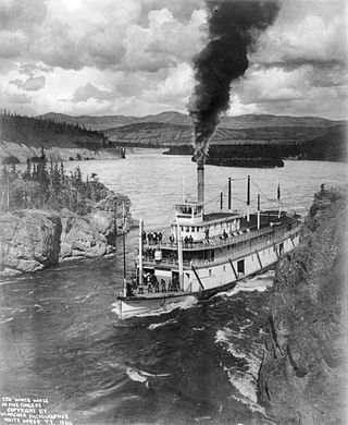
Steamboats on the Yukon River played a role in the development of Alaska and Yukon. Access to the interior of Alaska and Yukon was hindered by large mountains and distance, but the wide Yukon River provided a feasible route. The first steamers on the lower Yukon River were work boats for the Collins Overland Telegraph in 1866 or 1867, with a small steamer called Wilder. The mouth of the Yukon River is far to the west at St. Michael and a journey from Seattle or San Francisco covered some 4,000 miles (6,400 km).
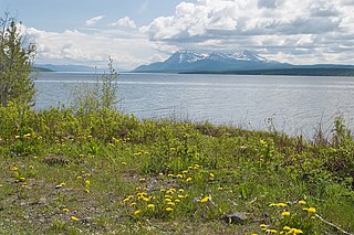
Teslin Lake is a large lake spanning the border between British Columbia and Yukon, Canada. It is one of a group of large lakes in the region of far northwestern BC, east of the upper Alaska Panhandle, which are the southern extremity of the basin of the Yukon River, and which are known in Yukon as "the Southern Lakes". The lake is fed and drained primarily by the Teslin River, south and north, but is also fed from the east by the Jennings River and the Swift River, and from the west by the Hayes River.
The Taku River Tlingit First Nation are the band government of the Inland Tlingit in far northern British Columbia, Canada and also in Yukon. They comprise two ḵwaan (tribes) of the Tlingit people, who are otherwise coastal, the Áa Tlein Ḵwáan of the Atlin Lake area and the Deisleen Ḵwáan of Teslin Lake, whose main focus is the Teslin Tlingit Council in Teslin, Yukon. Their band offices are in Atlin, British Columbia.
Pine Creek is a creek located in the Atlin Country region of British Columbia. Pine Creek flows out of Lake Surprise and empties into Atlin Lake just south of the town of Atlin. The creek is 12 miles in length. The gold bearing section is 2 miles long. This creek was staked in 1898 by Fritz Miller and Kenneth McLaren. By 1899, 3,000 prospectors stood on the banks of this creek. The largest nugget found weighed just over 48 ounces and was discovered in 1925. The creek has been worked with rockers, waterwheels, sluices and hydraulicked.
Dollis Creek is a creek that spans the border between British Columbia and the Yukon. The creek is 8 miles in length and flows from the Atlin Country region of British Columbia north across the BC-Yukon boundary into the Tatshenshini River approximately 10 miles from Old Dalton Post.

The Yukon Telegraph Trail, also known simply as the Telegraph Trail, is a historic pathway in the Canadian province of British Columbia that extends from the village of Ashcroft in the south to the community of Atlin in the north. It was used for servicing the Yukon Telegraph Line which ran from Ashcroft in the south to Dawson City, Yukon in the north. The telegraph line was constructed by the Dominion Government Telegraph Service from 1898 to 1901. It was abandoned in 1936 with the advent of radio communication. Along the length of the trail are remains of telegraph cabins, telegraph cable and other artifacts that were used during the construction of the telegraph line.
Egnell Creek is a tributary of the Hackett River in northwest part of the province of British Columbia, Canada. It flows generally southwest about 24 km (15 mi) to join the Hackett River near the Hackett's confluence with the Sheslay River, which in turn is a tributary of the Inklin River, the main southeast fork of the Taku River. Mount Egnell is located near the creek's mouth, as is the historic locality known as Egnell or Sheslay, once a telegraph station on the Yukon Telegraph Line.


