Coordinates: 48°43′49″N122°18′31″W / 48.73028°N 122.30861°W

A geographic coordinate system is a coordinate system that enables every location on Earth to be specified by a set of numbers, letters or symbols. The coordinates are often chosen such that one of the numbers represents a vertical position and two or three of the numbers represent a horizontal position; alternatively, a geographic position may be expressed in a combined three-dimensional Cartesian vector. A common choice of coordinates is latitude, longitude and elevation. To specify a location on a plane requires a map projection.

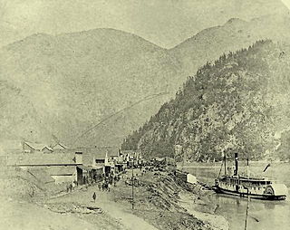
Only settlements extant in 1858 are shown
The Whatcom Trail was an overland trail from the Puget Sound area of Washington Territory during the Fraser Canyon Gold Rush of 1858. The trail began on Bellingham Bay, at Fairhaven (now a Bellingham neighbourhood), the route used went via a route known as the Columbia Valley, which is a lowland route connecting the mid-Nooksack River area with Cultus Lake and the lower Chilliwack River in the Upper Fraser Valley, about 80 km east of today's Vancouver. In 1858, T. G. Richards built the first brick building in Washington as an outfitter for those using the Whatcom Trail.

Puget Sound is a sound along the northwestern coast of the U.S. state of Washington, an inlet of the Pacific Ocean, and part of the Salish Sea. It is a complex estuarine system of interconnected marine waterways and basins, with one major and two minor connections to the open Pacific Ocean via the Strait of Juan de Fuca—Admiralty Inlet being the major connection and Deception Pass and Swinomish Channel being the minor.
The Territory of Washington was an organized incorporated territory of the United States that existed from March 2, 1853, until November 11, 1889, when the territory was admitted to the Union as the State of Washington. It was created from the portion of the Oregon Territory north of the lower Columbia River and north of the 46th parallel east of the Columbia. At its largest extent, it also included the entirety of modern Idaho and parts of Montana and Wyoming, before attaining its final boundaries in 1863.

The Fraser Canyon Gold Rush, began in 1857 after gold was discovered on the Thompson River in British Columbia at its confluence with the Nicoamen River a few miles upstream from the Thompson's confluence with the Fraser River at present-day Lytton. The rush overtook the region around the discovery, and was centered on the Fraser Canyon from around Hope and Yale to Pavilion and Fountain, just north of Lillooet.
The name "Whatcom" comes from the Lummi place name x̣ʷátqʷəm, probably meaning "noisy" with reference to a waterfall. [1]
Lummi is a dialect of the North Straits Salish language traditionally spoken by the Lummi people of northwest Washington, in the United States. Although traditionally referred to as a language, it is mutually intelligible with the other dialects of North Straits.
A more westerly route now in use for a major border crossing (at Sumas) was not usable due to the presence of Sumas Lake, a large shallow lake, now drained and turned into agricultural land. An alternate route to the main Whatcom Trail was the Skagit Trail, which went up the river of that name to its headwaters, from which another "back valley" emerges on the Fraser near Hope, then the HBC fur trading post Fort Hope.

Sumas is a small town in Whatcom County, Washington, United States. The population was 1,307 at the 2010 census. Sumas is located adjacent to the Canada–US border and borders the city of Abbotsford, British Columbia. The Sumas-Huntingdon port of entry at the north end of State Route 9 operates 24 hours a day. Sumas shares Nooksack Valley School District with the towns of Nooksack and Everson. Sumas is the northernmost settlement on Washington State Route 9 and experiences Astronomical Twilight for 22 days during the months of June and July.

Sumas Lake(Halq’eméyle: Semá:th Lake, Nooksack: Semáts Xácho7, .,) was a shallow freshwater lake surrounded by extensive wetlands. The traditional territory of the Sumas First Nation, a band of the Sto:lo Nation, it was located between Sumas and Vedder Mountains, midway between the present-day cities of Chilliwack and Abbotsford, British Columbia. The lake supported sturgeon, trout, salmon, grizzly bears and geese. Its wetland habitat was a destination for migrating birds and a breeding ground for both fish and waterfowl. Flocks of white-fronted goose as well as whistling swan and Hutchins geese also used the lake. Its partially sandy banks also provided for sturgeon spawning grounds. The lake supplied food to the Sumas Band, and their life ways were intimately connected to it. In the late 1800s, the lake drew the attention of various naturalists within the growing European populations engaged in the work of cataloging the flora and fauna of the New World.

The Fraser River is the longest river within British Columbia, Canada, rising at Fraser Pass near Blackrock Mountain in the Rocky Mountains and flowing for 1,375 kilometres (854 mi), into the Strait of Georgia at the city of Vancouver. It is the 11th longest river in Canada. The river's annual discharge at its mouth is 112 cubic kilometres (27 cu mi) or 3,550 cubic metres per second (125,000 cu ft/s), and it discharges 20 million tons of sediment into the ocean.
There are no known statistics for the number of goldseekers who travelled the Whatcom Trail during the gold rush, although certainly they may be counted in the thousands. Its existence was in open defiance of the edict from the British Governor on Vancouver Island that access to the Fraser goldfields must be made from Victoria, and then from there via the Fraser River only. In part this measure was intended to prevent the entry of large parties of armed Americans, and also to strip them of any handguns and any goods for trading with the Indians (still a Hudson's Bay Company monopoly during the gold rush).
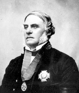
Sir James Douglas, was a Canadian fur trader and politician who became the 1st Governor of the Colony of British Columbia. He is often credited as "The Father of British Columbia". He started work at 16 for the North West Company and then the Hudson's Bay Company, becoming a high-ranking officer. From 1851 to 1864, he was Governor of the Colony of Vancouver Island. In 1858, he also became the first Governor of the Colony of British Columbia, in order to assert the authority of the British Empire during the Fraser Canyon Gold Rush, which had the potential to turn the B.C. Mainland into an American state. He remained governor of both colonies until his retirement in 1864.

Vancouver Island is in the northeastern Pacific Ocean. It is part of the Canadian province of British Columbia. The island is 460 kilometres (290 mi) in length, 100 kilometres (62 mi) in width at its widest point, and 32,134 km2 (12,407 sq mi) in area. It is the largest island on the West Coast of the Americas.

Victoria is the capital city of the Canadian province of British Columbia, located on the southern tip of Vancouver Island off Canada's Pacific coast. The city has a population of 85,792, while the metropolitan area of Greater Victoria has a population of 367,770, making it the 15th most populous Canadian metropolitan area. Victoria is the 7th most densely populated city in Canada with 4,405.8 people per square kilometre, which is a greater population density than Toronto.
The route's ongoing use was demonstration of the early colony's essential inability to prevent unregulated intrusion by US citizens, as was also the case with the Okanagan Trail. US troops of the Border Commission who were stationed near the route's southern US end were put on alert during the McGowan's War crisis, and were also stationed there during the San Juan Islands Dispute (the Pig War).

The Okanagan Trail was an inland route to the Fraser Canyon Gold Rush from the Lower Columbia region of the Washington and Oregon Territories in 1858-1859. The route was essentially the same as that used by the Hudson's Bay Company fur brigades, following the Columbia River to the confluence of the Okanogan River, and then up that river's watercourse via Osoyoos, Skaha (Dog) and Okanagan Lakes, then using a pass via Monte Creek to Fort Kamloops, at the confluence of the North and South Thompson Rivers. The route then went west from there down the Thompson River either to the lower gold-bearing bars of the Fraser River between what is now Lytton, British Columbia and Yale, British Columbia, or via Hat Creek and Marble Canyon to the upper Fraser goldfields around present-day Lillooet, British Columbia. A shorter branch-route to the lower Thompson and lower Fraser Canyon diverged from the main route at the confluence of the Similkameen River and the Okanogan. Cayoosh and The Fountains are today's Lillooet, British Columbia and environs.

McGowan's War was a bloodless war that took place in Yale, British Columbia in the fall of 1858. The conflict posed a threat to the newly established British authority on the British Columbia mainland, at the onset of the Fraser Canyon Gold Rush. It was called Ned McGowan's War after one of the conflict's main antagonists.

The San Juan Islands are an archipelago in the northwest corner of the contiguous United States between the U.S. mainland and Vancouver Island, British Columbia, Canada. The San Juan Islands are part of the U.S. state of Washington.
Similarly, on the Canadian side, the large tract of land in Sardis that for many years was Canadian Forces Base Chilliwack was laid aside as a military reserve during the scare over potential Fenian Raids in the 1870s and 1880s. That allocation, however, was as much a response to local Stó:lō First Nations numbers as it was to potential American aggression.
There is no border crossing at the Columbia Valley today, only a fence across farmland.