Lund, British Columbia

Last updated

Lund / ƛaʔamɩn (Klah ah men)
Lund BC from air.jpg
Lund, seen from a floatplane
Canada British Columbia location map 2.svg
Red pog.svg
Lund / ƛaʔamɩn (Klah ah men)
Location of Lund within British Columbia
Coordinates: 49°58′53″N124°45′42″W / 49.98139°N 124.76167°W / 49.98139; -124.76167
CountryFlag of Canada (Pantone).svg  Canada
Province Sheenu Has a Lund IN CorpFlag of British Columbia.svg  British Columbia
Regional District qathet Regional District
Founded1889 (1889)
Government
   MP Rachel Blaney (NDP)
   MLA Nicholas Simons (NDP)
Area
  Total10.57 km2 (4.08 sq mi)
Population
 (2021) [1]
  Total292
  Density28/km2 (72/sq mi)
Time zone UTC-8 (PST)
  Summer (DST) UTC-7 (PDT)
Postal code
V0N 2G0
Area code 604

Lund is a small craft harbour and unincorporated village on Tla'amin land in qathet Regional District, British Columbia, Canada. It is along the northern part of the Salish Sea on the mainland BC coast. The main landmark in the village is the Lund Hotel, established in 1905. By boat from Lund, the Copeland Islands (Copeland Islands Marine Provincial Park) and Desolation Sound, (which includes Desolation Sound Marine Provincial Park) are nearby. Lund is home to many shops and services including a general store, a restaurant overlooking the water, kayak and adventure tourism stores, and Nancy's Bakery, a favourite of locals and tourists.

Contents

History

Lund was named by brothers Frederick and Charles Thulin, who came from Tryserum near Valdemarsvik, Sweden. When they settled at the harbour in December 1889, they named it after Lund, Sweden, because it was Swedish and fairly easy for non-Scandinavians to pronounce. [2] [3] When they arrived, the harbour was a Tla'amin village named ƛaʔamɩn (Klah ah men) . [4] The Thulins built a store and in 1892 a post office was added followed by the first licensed hotel north of Vancouver two years later. Logging and fishing were the source of income in the early years. Transportation was by water. A second hotel, called the Malaspina, was built by the Thulins. When the original hotel was destroyed by a forest fire in 1918, the newer hotel, which continues to operate in the village, was renamed the Lund Hotel. A paved road leading south to Vancouver was completed in 1954 and coastal steamer service ended two years later. The original wharf built by the Thulins was damaged by a storm in 1954 and replaced by a government wharf. [4]

Transportation

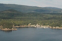
Lund is the northern terminus of Highway 101. The highway is locally known as the Sunshine Coast Highway. Powell River is 22 kilometres (14 mi) south by road, from where BC Ferries offers service to Comox on Vancouver Island to the west across the Strait of Georgia. Transportation is also available from Powell River by private aircraft or scheduled service with Pacific Coastal Airlines, which offers half-hour flights to Vancouver. Road access to Vancouver to the south involves two ferry crossings of fjords along the Sunshine Coast.

Lund harbour provides marine vessel access including regular water taxi service to Savary Island

Savary Island Ferry at Dock Savary Island Ferry at Dock.jpg
Savary Island Ferry at Dock

and is accessible by chartered float plane.

Government and politics

As an unincorporated community, municipal government is provided by the qathet Regional District.

Lund is a part of the North Island-Powell River federal riding. Rachel Blaney, of the New Democratic Party of Canada, is the Member of Parliament. She was elected to represent the riding in the 2015 federal election.

Nicholas Simons of the NDP was elected to represent Lund as part of the Powell River-Sunshine Coast constituency in the 2005 BC general election and re-elected in 2009 and in 2013.

The Northside Volunteer Fire Department (NVFD) provides fire and emergency response services to the area from just north of the Village of Lund south to Wilde Road and includes properties on the west side of Okeover Inlet as far north as Penrose Bay.

Education

Since 2010, Puddle Jumpers, a pre-school operating out of the Northside Community Recreation Center runs twice a week with about 13 children on average attending.

Media

The Lund Barnacle is a quarterly magazine published by the Lund Community Society that covers the events and stories of the community. It is available at many shops in Lund and online. It was founded in 1988 and is still completely volunteer-run.

Arts & Culture

Lund is home to a number of galleries and studios including the Tidal Art Centre, the Tug-Guhm Gallery Studio, Three Stone Soup Fibre Studio and Rare Earth Pottery.

Lund harbour panorama.jpg
Docks at Lund Harbour

Related Research Articles

British Columbia Highway 101, also known as the Sunshine Coast Highway, is the main north–south thoroughfare on the Sunshine Coast, British Columbia, Canada.

<span class="mw-page-title-main">Madeira Park</span>

Madeira Park is an unincorporated community in the area of Pender Harbour on the Sunshine Coast of southwestern British Columbia, Canada.

<span class="mw-page-title-main">Powell River, British Columbia</span> City in British Columbia, Canada

Powell River is a city on the northern Sunshine Coast of southwestern British Columbia, Canada. Most of its population lives near the eastern shores of Malaspina Strait, which is part of the larger Georgia Strait between Vancouver Island and the Mainland. With two intervening long, steep-sided fjords inhibiting the construction of a contiguous road connection with Vancouver to the south, geographical surroundings explain Powell River's remoteness as a community, despite relative proximity to Vancouver and other populous areas of the BC Coast. The city is the location of the head office of the qathet Regional District.

<span class="mw-page-title-main">Sunshine Coast (British Columbia)</span> Subregion of British Columbia in Canada

The Sunshine Coast is a geographic subregion of the British Columbia Coast that generally comprises the regional districts of qathet and Sunshine Coast.

qathet Regional District Regional district in British Columbia, Canada

The qathet Regional District is a regional district in the Canadian province of British Columbia. Its only incorporated municipality is the City of Powell River, although it includes a number of unincorporated areas. The district encompasses a land area of 5,075.33 square kilometres (1,959.60 sq mi). The district was formerly known as the Powell River Regional District. Because of frequent confusion between the identical names of Powell River district and city, the district's name was changed in 2018 to qathet, from q̓at̓ᶿət, meaning "working together, bringing together" in the Comox language of the Tla'amin Nation.

<span class="mw-page-title-main">Sechelt</span> Netherlands 23

Sechelt is a district municipality located on the lower Sunshine Coast of British Columbia. Approximately 50 km northwest of Vancouver, it is accessible from mainland British Columbia by a 40-minute ferry trip between Horseshoe Bay and Langdale, and a 25-minute drive from Langdale along Highway 101, also known as the Sunshine Coast Highway. The name Sechelt is derived from the she shashishalhem word shíshálh, the name of the First Nations people who first settled the area thousands of years ago.

<span class="mw-page-title-main">Lasqueti Island</span>

Lasqueti Island is an island off the east coast of Vancouver Island in the Strait of Georgia, qathet Regional District, British Columbia, Canada and has a population of 498. A passenger-only ferry connects the island to the community of French Creek, near Parksville. The ferry makes two to three runs per day, six days per week, weather permitting. The ferry service is run by Western Pacific Marine for BC Ferries.

<span class="mw-page-title-main">British Columbia Coast</span> Coastal region of British Columbia, Canada

The British Columbia Coast, popularly referred to as the BC Coast or simply the Coast, is a geographic region of the Canadian province of British Columbia. As the entire western continental coastline of Canada along the Pacific Ocean is in the province, it is synonymous with being the West Coast of Canada.

<span class="mw-page-title-main">Desolation Sound</span> Sound in Discovery Islands, British Columbia

Desolation Sound is a deep water sound at the northern end of the Salish Sea and of the Sunshine Coast in British Columbia, Canada.

<span class="mw-page-title-main">Copeland Islands Marine Provincial Park</span> Provincial park in British Columbia, Canada

Copeland Islands Marine Provincial Park is a provincial park in British Columbia, Canada, located in Desolation Sound to the northwest of Lund on the northern Sunshine Coast off the west coast of the Malaspina Peninsula.

<span class="mw-page-title-main">Savary Island</span>

Savary Island or Áyhus is an island in British Columbia, Canada. Located in the northern part of the Strait of Georgia, it is 144 kilometres (89 mi) northwest of Vancouver. It is approximately 0.8-1.5 km wide and 7.5 kilometres (4.7 mi) long. It has a permanent population of about 100, expanding to perhaps 2,000 or more in the summer months. Savary Island lies within the traditional territory of the Tla'amin Nation.

<span class="mw-page-title-main">Cortes Island</span> Island of the Discovery Islands in British Columbia, Canada

Cortes Island is an island in the Discovery Islands archipelago on the coast of British Columbia, Canada. The island is 25 km (16 mi) long, 13 km (8 mi) wide, and 130 km2 (50 sq mi) in area. It has a population of 1,035 permanent residents. Cortes Island lies within Electoral Area B of the Strathcona Regional District, which provides water and sewerage systems, fire protection, land use planning, parks, recreation, and emergency response.

<span class="mw-page-title-main">Vancouver Coastal Health</span> Regional health authority in British Columbia, Canada

Vancouver Coastal Health (VCH) is a regional health authority that provides health services including primary, secondary, tertiary and quaternary care, home and community care, mental health services, population and preventive health and addictions services in part of Greater Vancouver and the Coast Garibaldi area.

Gambier Island is an island located in Howe Sound near Vancouver, British Columbia. It is about 17,049 acres in size and is located about 10 kilometres north of the Horseshoe Bay community and ferry terminal in westernmost West Vancouver.

<span class="mw-page-title-main">Tla'amin Nation</span> First Nations place in Canada

The Tla'amin First Nation, formerly Sliammon Indian Band or Sliammon First Nation, is a First Nations self governing nation whose lands and traditional territories are located on the upper Sunshine Coast in southwestern British Columbia, Canada. The Tla'amin are closely related to the Klahoose and Homalco peoples and have shared their adjoining territories; formerly all three as well as K'omoks were grouped collectively as the Mainland Comox due to their shared language. They have been part of the Coast Salish indigenous peoples of the western coast of Canada since ancient times.

<span class="mw-page-title-main">Ahgykson Island</span> Island in British Columbia, Canada

Ahgykson Island, formerly Harwood Island, is a small island off the coast of Powell River, BC. It is an indian reserve and part of the traditional territory of the Sliammon First Nation.

<span class="mw-page-title-main">South Thormanby Island</span> Island in British Columbia, Canada

<span class="mw-page-title-main">Israel Wood Powell (British Columbia politician)</span> British Columbia Politician

Israel Wood Powell was B.C.'s first superintendent of Indian Affairs and a businessman, politician and doctor. He served in the Legislative Assembly of Vancouver Island from 1863 to 1866.

Grace Harbour is a harbour and traditional village site of the Tla'amin peoples in the South Coast of British Columbia, located near Desolation Sound on the south side of the Gifford Peninsula opposite the Malaspina Peninsula to the southwest. Along with the Gifford Peninsula, it is part of Desolation Sound Marine Provincial Park. Kahkaykay Indian Reserve No. 6 was located on the west side of the harbour but as of 2011 is now fee-simple land as a result of the Sliammon Treaty. at 50°02′58″N124°45′21″W The headland at the southwest corner of the harbour is similarly named from the name of the ancient village at this site, Kakaekae Point, at 50°02′32″N124°45′56″W

<span class="mw-page-title-main">Sunshine Coast Trail</span>

The Sunshine Coast Trail is a 180 km (112 mi) wilderness hiking trail in the Sunshine Coast region of British Columbia, Canada. The trail traverses the qathet Regional District from Sarah Point on the Desolation Sound in the north to the BC Ferries terminal at Saltery Bay on Jervis Inlet in the south. The trail goes within close proximity of the communities of Powell River, Lang Bay, Lund, and Teeshohsum, through public, private and Tla'amin Nation treaty lands. It connects provincial parks such as Malaspina Provincial Park and Inland Lake Provincial Park, as well as many recreation sites and regional parks.

References

  1. Census Profile, 2021 Census – Lund, Unincorporated place Designated place, British Columbia Province
  2. Akrigg, G.P.V.; Akrigg, Helen B (1973) [1969]. 1001 British Columbia Place Names (3rd [rev.] ed.). Vancouver: Discovery Press. p. 106. OCLC   923074.
  3. Radio, Sveriges. "Östgötar i Vancouver- Bröderna Thulin – Förmiddag i P4 Östergötland" . Retrieved June 20, 2016.
  4. 1 2 White, Howard, ed. (1994). "Shirley Corbett". Raincoast Chronicles Eleven Up . Madeira Park, BC: Harbour Publishing. pp.  33, 36. ISBN   978-1-55017-105-1. OCLC   30664446.