Highway 99A is a series of former highways in the southwestern part of British Columbia, Canada. It was the designation of the former 1942 alignment of Highway 99 as well a various alternate routes which existed in the 1950s and 1960s. The last official use of '99A' was decommissioned in 2006, although some present-day, commercially published road maps still show it and some remnant signage still remains. Some brand new 99A signs can be seen as well as of 2023.
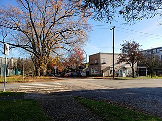
Hastings–Sunrise is a neighbourhood located in the northeastern corner of the city of Vancouver, British Columbia.

Kingsway is a major thoroughfare that crosses through the Canadian cities of Vancouver and Burnaby, British Columbia. The road runs diagonally from northwest to southeast, emerging from Vancouver's Main Street just south of East 7th Avenue and becoming 12th Street at the Burnaby–New Westminster border.

The 98 B-Line was a bus rapid transit line in Metro Vancouver, British Columbia, Canada, that began service in September 2000. It linked Richmond to Downtown Vancouver, with a connection to Vancouver International Airport. It travelled mainly along Granville Street in Vancouver and a dedicated bus lane on No. 3 Road in Richmond. It was operated by Coast Mountain Bus Company and was funded by TransLink. The route was 16 kilometres (9.9 mi) long. The line carried over 18,000 passengers daily. It was discontinued in September 2009, shortly after the opening of the Canada Line, which replaced it.
Transportation in Vancouver, British Columbia, has many of the features of modern cities worldwide. Unlike many large metropolises, Vancouver has no freeways into or through the downtown area. A proposed freeway through the downtown was rejected in the 1960s by a coalition of citizens, community leaders and planners. This event "signalled the emergence of a new concept of the urban landscape" and has been a consistent element of the city's planning ever since.

East Vancouver is a region within the city of Vancouver, British Columbia, Canada. Geographically, East Vancouver is bordered to the north by Burrard Inlet, to the south by the Fraser River, and to the east by the city of Burnaby. East Vancouver is divided from Vancouver's "West Side" by Ontario Street.

Oakridge is a neighbourhood in Vancouver, British Columbia, Canada, with a multicultural residential and commercial area. It had a population of 13,030 in 2016, of which approximately 50 percent have Chinese as their mother tongue.

Renfrew–Collingwood is a large neighbourhood that lies on the eastern side of Vancouver, British Columbia, Canada, on its boundary with Burnaby and encompassing an area that was one of the earlier developed regions of the city. It is a diverse area that includes a substantial business community in several areas, as well as some of the fastest-growing residential sectors of Vancouver. In 2011, the neighbourhood had a population of 50,500, 38.4% of whom claim Chinese as their first language.
North Burnaby is a general name for a large neighbourhood in the City of Burnaby, British Columbia, that includes a number of smaller ones. It stretches from Boundary Road in the west to Burnaby Mountain with Simon Fraser University in the east and is bounded by Burrard Inlet to the north and the Lougheed Highway to the south. It is a desirable place to live for many local and immigrant families, which is reflected by real-estate prices that keep climbing and have doubled in the last 15 years.

Georgia Street is an east–west street in the cities of Vancouver and Burnaby, British Columbia, Canada. Its section in Downtown Vancouver, designated West Georgia Street, serves as one of the primary streets for the financial and central business districts, and is the major transportation corridor connecting downtown Vancouver with the North Shore by way of the Lions Gate Bridge. The remainder of the street, known as East Georgia Street between Main Street and Boundary Road and simply Georgia Street within Burnaby, is more residential in character, and is discontinuous at several points.
Main Street is a major north–south thoroughfare bisecting Vancouver, British Columbia, Canada. It runs from Waterfront Road by Burrard Inlet in the north, to Kent Avenue alongside the north arm of the Fraser River in the south.

Broadway is a major east–west thoroughfare in the city of Vancouver, British Columbia, Canada. In Vancouver's numbered avenue grid system, it runs in place of a 9th Avenue, between 8th and 10th. The street has six lanes for most of its course. Portions of the street carry the British Columbia Highway 7 designation.
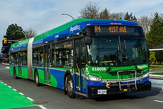
The R4 41st Ave is an express bus route with bus rapid transit elements in Metro Vancouver, British Columbia, Canada. Part of TransLink's RapidBus network, it replaced the 43 Express that travelled along 41st Avenue, a major east–west route that connects the University of British Columbia (UBC) to the SkyTrain system's Oakridge–41st Avenue station on the Canada Line and Joyce–Collingwood station on the Expo Line.
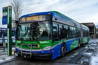
The R5 Hastings St is an express bus service with bus rapid transit elements in Metro Vancouver, Canada. Part of TransLink's RapidBus network, it travels along Hastings Street, a major east–west route, and connects Simon Fraser University to the SkyTrain system's Burrard station on the Expo Line in Downtown Vancouver. It replaced the 95 B-Line route on January 6, 2020.

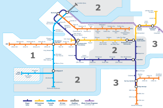
The Vancouver trolley bus system forms part of the TransLink public transport network serving Metro Vancouver in the Canadian province of British Columbia. Opened in 1948, the system was originally owned and operated by the British Columbia Electric Railway. By 1954, Vancouver had the largest trolley bus fleet in Canada, with 327 units, and the fleet grew to an all-time peak of 352 in early 1957. There were 19 routes by 1955 and a peak of 20 by the second quarter of 1957. The last route to open in the 1950s was the only express trolley bus service that ever existed in Canada. Several, mostly short, extensions to the system were constructed in the 1980s and later.
Marine Drive is the name for three major roadways in Greater Vancouver, British Columbia, Canada. The roads are known for running parallel to major bodies of water, with some sections being a major arterial road, while other serve local traffic. Marine Way is the name applied to a section of Marine Drive that was bypassed in the early 1980s.