
The Okanogan River is a tributary of the Columbia River, approximately 115 mi (185 km) long, in southern British Columbia and north central Washington. It drains a scenic plateau region called the Okanagan Country east of the Cascade Range and north and west of the Columbia, and also the Okanagan region of British Columbia. The Canadian portion of the river has been channelized since the mid-1950s.

Summerland is a town on the west side of Okanagan Lake in the interior of British Columbia, Canada. The district is between Peachland to the north and Penticton to the south. The largest centre in the region is Kelowna, approximately 50 km (31 mi) to the north, and Vancouver is approximately 425 km (264 mi) away to the west. The district is famous for "Bottleneck drive", a system of roads connecting a large number of wineries.

The Regional District of Central Okanagan (RDCO) is a regional district in the Canadian province of British Columbia, comprising the City of Kelowna, City of West Kelowna and their surrounding municipalities. The regional district's offices are located in Kelowna.

Fintry is a small community in British Columbia, Canada. It lies on the west shore of Okanagan Lake, 24 kilometres (15 mi) north of the city of Kelowna, and 50 kilometres (31 mi) south of Vernon. It has about 50 homes and is at the bottom of a three kilometre steep windy road off West Side Road. There are a few public beaches as well as a provincial campground.
Neville Langrell (Bill) Barlee was a Canadian politician who was first elected to the Legislative Assembly of British Columbia as a New Democrat in 1988. He served as Minister of Agriculture, Fisheries and Food from 1991 until 1993 and then as Minister of Small Business, Tourism and Culture from 1993 until 1996.
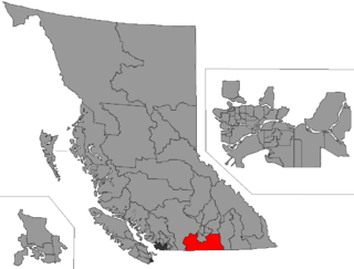
Boundary-Similkameen is a provincial riding formed in 2008. It includes the populations of Penticton-Okanagan Valley, West Kootenay-Boundary and Yale-Lillooet. The riding's name corresponds to that of a former riding in the same area, with similar but not identical boundaries.
Okanagan-Boundary was a provincial electoral district in the Canadian province of British Columbia spanning the area from the Similkameen towns of Kaleden and Keremeos to Grand Forks and Christina Lake, and including the southern Okanagan towns of Okanagan Falls, Oliver, Osoyoos, Rock Creek and Greenwood. The riding first appeared in the 1991 election as the result of a redistribution of the former riding of Boundary-Similkameen. The same area is now part of West Kootenay-Boundary.

Darke Lake Provincial Park is a provincial park in British Columbia, Canada located west of Okanagan Lake, southwest of the town of Peachland in that province's Okanagan region. The park is approximately 1,470 hectares in size and was established in 1968. Darke Lake, also mapped historically as Fish Lake, is northwest of Summerland and is named after Silas Robert Darke, an early settler in the 1890s.

Sẁiẁs Provincial Park is a provincial park in British Columbia, Canada, located on the west side of Osoyoos Lake in the town of Osoyoos, which is on the United States-Canada border at the southern end of the Okanagan region of British Columbia. Now approximately 38 ha. in size, the park was originally created in 1939 and has been decreased and then increased in size since then. The name was changed from Haynes Point to sẁiẁs, the original Okanagan (Syilx'tsn) name for the region, meaning "narrowing of the waters".
The Boundary Country is a historical designation for a district in southern British Columbia lying, as its name suggests, along the boundary between Canada and the United States. It lies to the east of the southern Okanagan Valley and to the west of the West Kootenay. It is often included in descriptions of both of those regions but historically has been considered a separate region. Originally inclusive of the South Okanagan towns of Osoyoos and Oliver, today the term continues in use to refer to the valleys of the Kettle, West Kettle, and Granby Rivers and of Boundary and Rock Creeks and that of Christina Lake and of their various tributaries, all draining the south slope of the Monashee Mountains The term Boundary District as well as the term Boundary Country can both refer to the local mining division of the British Columbia Ministry of Mines, Energy and Petroleum Resources.
The Shuswap Country, or simply the Shuswap is a term used in the Canadian province of British Columbia to refer to the environs of Shuswap Lake. The upper reaches of the Shuswap basin, southeast of Shuswap Lake and northeast of the Okanagan, are generally considered to be part of Okanagan or of the Monashee Country rather than "the Shuswap". Roughly defined, the Shuswap Country begins on its west at the town of Chase, located on Little Shuswap Lake, west of which is the South Thompson area of the Thompson Country, and includes Adams Lake to the northwest of Shuswap Lake as well as communities in the Eagle River area as far as Craigellachie and/or Three Valley Gap, which is at the summit of Eagle Pass, beyond which eastwards is the Columbia Country.

Rock Creek is an unincorporated settlement in the Boundary Country of the Southern Interior of British Columbia, Canada. Located at the confluence of the Kettle River with the eponymous Rock Creek, site of the Rock Creek Gold Rush of 1860, the community also lies at the junction of British Columbia Highway 33 and British Columbia Highway 3, otherwise known as the Crowsnest Highway, which runs across the south of the province.
Comaplix is the name of former mining town on the Incomappleux River in the northern Arrow Lakes region of British Columbia's Kootenay Country in Canada. The name of the town and an adjacent mountain and creek are derived from that of the river, which is an Okanagan word meaning "point at the head of the lake". The location, now flooded, is on the northeast side of Beaton Arm of Upper Arrow Lake, near the sites of Beaton and Camborne.
Fairview is a ghost town in British Columbia on the west side of the Okanagan River between Cawston and Oliver. It is the original townsite for what is now the town of Oliver, famous for the Fairview Hotel that burned down in the 1902.
Cherry Creek is a creek located in the Okanagan region of British Columbia. The south fork of Cherry Creek is known as Monashee Creek. Cherry Creek was discovered in the 1800s and mined for gold. The Creek was mined in the 1800s by Christian, Schneider, Bissett, and Leblanc. Chinese and European miners worked Cherry Creek. The largest gold nugget found in Cherry Creek weighed 8 to 9 ounces with a value of $130.
Harris Creek is a creek in the Okanagan region of British Columbia. The creek is located to the south of the village of Lumby in the North Okanagan. Harris Creek has been mined for gold. The total output mined for Harris Creek amounts to $125,000.
Lambly Creek is located in the Okanagan region of British Columbia. The creek flows into Okanagan Lake from the west across from Kelowna. Lambly Creek is also known as Bear Creek. In 1876, gold was discovered in the Creek. The creek was mined for gold. Gold Nuggets with a $5 value have been recovered from the creek.

Mission Creek is a large creek in the Okanagan Region of British Columbia. Originally called N'wha-kwi-sen, it was later mapped as L’Anse-au-Sable, the name Mission Creek was adopted in 1860 in honour of the Catholic Oblate Mission established by Father Pandosy and other settlers. The Creek rises in the Greystoke Mountain Range and runs west about 43 kilometres (27 mi) before emptying into Okanagan Lake south of Kelowna. Its watershed covers about 200,000 square kilometres . Mission Creek was designated a BC Heritage River by the province in 1996.
Nashwito Creek is located in the Okanagan region of British Columbia. The creek flows into Okanagan Lake from the west. Nashwito Creek is located a few miles south of Vernon, British Columbia. The creek is also called Siwash Creek which should not be confused with Siwash Creek near Princeton, British Columbia. Nashwito Creek has been mined for gold.
Whiteman Creek is a creek located in the Okanagan Region of British Columbia. The creek flows into Okanagan Lake from the west. Whiteman Creek was discovered in the 1870s. The creek has been mined.


