100 Mile House is a town and district municipality located in the South Cariboo region of central British Columbia, Canada.
Lillooet, formerly Cayoosh Flat, is a community on the Fraser River in British Columbia, Canada, about 240 kilometres (150 mi) up the British Columbia Railway line from Vancouver. Situated at an intersection of deep gorges in the lee of the Coast Mountains, it has a dry climate with an average of 329.5 millimetres (13 in) of precipitation being recorded annually. Lillooet has a long growing season, and once had prolific market gardens and orchard produce. It often vies with Lytton and Osoyoos for the title of "Canada's Hot Spot" on a daily basis in summer.
Hudson's Hope is a district municipality in northeastern British Columbia, Canada, in the Peace River Regional District. It covers an area of 927 square kilometres (358 sq mi) with a population of 1,157 people. Having been first settled along the Peace River in 1805, it is the third-oldest European-Canadian community in the province, although it was not incorporated until 1965. Most jobs in the economy are associated with the nearby W. A. C. Bennett Dam and Peace Canyon Dam, and timber logging.
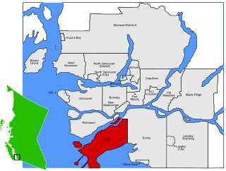
Delta is a city in British Columbia, and forms part of Greater Vancouver. Located south of Richmond, it is bordered by the Fraser River to the north, the United States to the south and the city of Surrey to the east. Delta is composed of three distinct communities: Ladner, Tsawwassen, and North Delta.

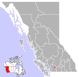
Castlegar is the second largest community in the West Kootenay region of British Columbia, Canada.
Spuzzum is an unincorporated settlement in British Columbia, Canada. Because it is on the Trans-Canada Highway, approximately 50 kilometres (31 mi) north of the community of Hope, it is often referred to as being "beyond Hope". Spuzzum was immortalized in the early 1980s by the band "Six Cylinder" in a song with the refrain "If you haven't been to Spuzzum, you ain't been anywhere."

The City of Enderby is in the North Okanagan region of the Canadian province of British Columbia, between Armstrong and Salmon Arm. It is approximately 80 km north of Kelowna and 130 km east of Kamloops. Highway 97A passes through Enderby and the Shuswap River marks the eastern and northeastern limits of the City. There are two major schools in Enderby: M.V. Beattie Elementary School and A.L. Fortune Secondary School. M.V. Beattie Elementary School was rebuilt in 2012.
Port Douglas, sometimes referred to simply as Douglas, is a remote community in British Columbia, Canada at east of the mouth of the Lillooet River, and at the head of Harrison Lake, which is the head of river navigation from the Strait of Georgia. Port Douglas was the second major settlement of any size on the British Columbia mainland during the Fraser Canyon Gold Rush.

Mount Tiedemann 3838m, prominence 848m, is one of the principal summits of the Pacific Ranges subdivision of the Coast Mountains of British Columbia. It is located 3 km (1.9 mi) northeast of Mount Waddington in the Waddington Range massif between the Homathko and Klinaklini Rivers.
Fort Babine, British Columbia (Wit'at) is a small native reserve community, located at the northern tip of Babine Lake, approximately 100 km north of Smithers. It is accessible by an all-weather gravel logging road. There are approximately 60 year-round residents. The community comprises five Indian reserves in the area, Babine Indian Reserve No. 16, Babine Indian Reserve No. 6, Casdeded Indian Reserve No. 8, No-Cut Indian Reserve No. 5, and Alphonse Tommy Indian Reserve No. 7.
Zeballos is a village located on the northwest coast of Vancouver Island in British Columbia, Canada. While legend suggests Spanish gold seekers may have explored the area in the late 16th century, Zeballos is now known for its ecotourism and sport fishing.
Spences Bridge is a community in the Canadian province of British Columbia, situated 35 km north east of Lytton and 44 km south of Ashcroft. In 1892, the population included 32 people of European ancestry and 130 First Nations people. There were five general stores, three hotels, one Church of England and one school. The principal industries are fruit growing and farming. The population as of 2016 is 99.

Joe Capilano (1850–1910), also known as Joe Mathias, was a leader of the Squamish from 1895-1910, who called him Sa7plek (Sahp-luk). He fought for the recognition of native rights and lifestyle.
150 Mile House is an unincorporated community of 893 people in the Cariboo region of British Columbia. It is located 15 km southeast of Williams Lake on Highway 97.
Mount Lehman or Mt. Lehman is a small rural community located in the Fraser Valley of south western British Columbia, Canada. The community was established in 1874 and became part of the District of Matsqui in 1892. The District of Matsqui was incorporated into the present day City of Abbotsford, British Columbia in 1995.
Whonnock is a rural, naturally treed, and hilly community on the north side of the Fraser River in the eastern part of the City of Maple Ridge, British Columbia, Canada. It is approximately 56 kilometres east of Downtown Vancouver on the Lougheed Highway Whonnock shares borders with three other Maple Ridge communities. To the west the borders are 256th Street with Albion and upper Kanaka Creek with Webster's Corners. To the east Whonnock Creek forms the border with Ruskin. To the north is the municipal border and to the south the Fraser River.
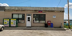
Ryder Lake is a small, sub-alpine, farming-based community located in Chilliwack, British Columbia, situated on Mount Thom to the west of Lookout Ridge. A post office operated here from 1926 to 1940 Notable features in Ryder Lake include a former small elementary school and small fire hall.
Chilliwack is a city made up of several amalgamated villages and communities. The urban core has a decidedly North-South axis bisected by the Trans-Canada Highway. The city is bounded in north by the Fraser River, in the east by the Eastern Hillsides, in the south by the Canada-U.S. border, and in the west by the Vedder Canal.

Hatzic is a historic community in the Central Fraser Valley region of the Lower Mainland of British Columbia, Canada, located on the east side of the District of Mission and including areas beyond the municipal boundary to the east and northeast.