Cartwright Natsitok [1] | |
---|---|
Town | |
Coordinates: 53°42′24″N57°01′11″W / 53.70667°N 57.01972°W | |
Country | Canada |
Province | Newfoundland and Labrador |
Settled | 1775 |
Incorporated | 1956 |
Government | |
• Mayor | Robyn Holwell |
Area | |
• Land | 3.27 km2 (1.26 sq mi) |
Elevation | 10 m (30 ft) |
Population (2021) | |
• Total | 439 |
Time zone | UTC−04:00 (AST) |
• Summer (DST) | UTC−03:00 (ADT) |
Area code | 709 |
Highways | Route 516 (Cartwright Highway) |
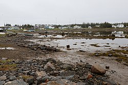
Cartwright is a community located on the eastern side of the entrance to Sandwich Bay, along the southern coast of Labrador in the province of Newfoundland and Labrador, Canada. It was incorporated in 1956.
Cartwright is located within in Sandwich Bay an area with a longstanding Inuit presence known to resident Inuit as Natsiktok or place of the ring seals. Archeological evidence, especially that excavated by Dr. Lisa Rankin indicates an early and year round Inuit presence.
Cartwright has been a settled community since 1775. In 1775, Captain George Cartwright, for whom the place is named, settled there, establishing a fish and fur trading business. He left Labrador in 1786, maintaining a business interest there until it was sold to Hunt and Henley in 1815. It was again sold in 1873 to the Hudson's Bay Company and has remained under company ownership ever since. The residents of Sandwich Bay (including Cartwright) were described by Rev. Bishop Field in 1848 as either 'pure Esquimaux' or 'Anglo-Esquimaux, with an admixture of old English settlers'.
Since 2002, Cartwright has been connected by road (a section of the Trans-Labrador Highway, Route 516) with Blanc Sablon, Quebec, where there is a car ferry to Newfoundland. [2] Since December 2009 the remaining link between Cartwright and Happy Valley-Goose Bay, Labrador has been completed and open to the public. [3] [4] [5]
Year | Pop. | ±% |
---|---|---|
2006 | 552 | — |
2011 | 504 | −8.7% |
2016 | 427 | −15.3% |
2021 | 439 | +2.8% |
[6] [7] |
In the 2021 Census of Population conducted by Statistics Canada, Cartwright, Labrador had a population of 439 living in 204 of its 243 total private dwellings, a change of 2.8% from its 2016 population of 427. With a land area of 5.87 km2 (2.27 sq mi), it had a population density of 74.8/km2 (193.7/sq mi) in 2021. [7]
Cartwright has a subarctic climate ( Dfc ) with very snowy winters and short, mild summers. Owing to its maritime location, the winters are however a little milder than on most of the Labrador Peninsula, but snow depth from the stormy Icelandic Low, which circulates cold and saturated air around the region, is extreme: it averages around 160 centimetres (63 in) at its peak early in March and has reached as high as 351 centimetres (138 in) on April 7, 2003. [8] Snow is usually fully melted early in June and is established again in early November. [8] Unlike most of Labrador, there is no permafrost because of the insulation from the deep snow cover, although the annual mean temperature is 0.0 °C (32.0 °F).
Climate data for Cartwright (1981−2010) | |||||||||||||
---|---|---|---|---|---|---|---|---|---|---|---|---|---|
Month | Jan | Feb | Mar | Apr | May | Jun | Jul | Aug | Sep | Oct | Nov | Dec | Year |
Record high °C (°F) | 11.8 (53.2) | 11.7 (53.1) | 16.4 (61.5) | 18.2 (64.8) | 30.0 (86.0) | 35.3 (95.5) | 36.1 (97.0) | 33.0 (91.4) | 30.0 (86.0) | 23.3 (73.9) | 19.7 (67.5) | 13.3 (55.9) | 36.1 (97.0) |
Average high °C (°F) | −9.5 (14.9) | −8.5 (16.7) | −3.6 (25.5) | 2.4 (36.3) | 7.7 (45.9) | 13.8 (56.8) | 17.8 (64.0) | 18.0 (64.4) | 13.3 (55.9) | 6.8 (44.2) | 1.0 (33.8) | −5.0 (23.0) | 4.5 (40.1) |
Daily mean °C (°F) | −14.3 (6.3) | −13.5 (7.7) | −8.7 (16.3) | −1.8 (28.8) | 3.3 (37.9) | 8.6 (47.5) | 12.3 (54.1) | 12.7 (54.9) | 9.0 (48.2) | 3.7 (38.7) | −2.0 (28.4) | −8.8 (16.2) | 0.0 (32.0) |
Average low °C (°F) | −18.9 (−2.0) | −18.5 (−1.3) | −13.8 (7.2) | −6.1 (21.0) | −1.1 (30.0) | 3.4 (38.1) | 6.8 (44.2) | 7.4 (45.3) | 4.6 (40.3) | 0.5 (32.9) | −4.9 (23.2) | −12.6 (9.3) | −4.4 (24.1) |
Record low °C (°F) | −37.8 (−36.0) | −34.5 (−30.1) | −32.2 (−26.0) | −25.6 (−14.1) | −15.0 (5.0) | −5.6 (21.9) | −1.7 (28.9) | −0.6 (30.9) | −5.0 (23.0) | −11.7 (10.9) | −21.1 (−6.0) | −33.9 (−29.0) | −37.8 (−36.0) |
Average precipitation mm (inches) | 86.4 (3.40) | 90.7 (3.57) | 92.1 (3.63) | 75.1 (2.96) | 68.2 (2.69) | 98.7 (3.89) | 100.8 (3.97) | 94.1 (3.70) | 89.4 (3.52) | 101.5 (4.00) | 84.7 (3.33) | 92.0 (3.62) | 1,073.5 (42.26) |
Average rainfall mm (inches) | 5.3 (0.21) | 9.8 (0.39) | 10.5 (0.41) | 21.1 (0.83) | 47.9 (1.89) | 95.0 (3.74) | 100.8 (3.97) | 94.1 (3.70) | 88.8 (3.50) | 88.6 (3.49) | 37.6 (1.48) | 17.6 (0.69) | 616.8 (24.28) |
Average snowfall cm (inches) | 83.7 (33.0) | 82.2 (32.4) | 80.7 (31.8) | 54.4 (21.4) | 20.5 (8.1) | 3.0 (1.2) | 0.0 (0.0) | 0.0 (0.0) | 0.8 (0.3) | 12.7 (5.0) | 48.0 (18.9) | 76.0 (29.9) | 462.0 (181.9) |
Average precipitation days (≥ 0.2 mm) | 16.1 | 14.5 | 16.2 | 14.2 | 16.3 | 17.7 | 19.0 | 17.5 | 17.2 | 18.0 | 15.9 | 17.0 | 199.7 |
Average rainy days (≥ 0.2 mm) | 2.2 | 2.4 | 4.0 | 6.2 | 12.5 | 17.5 | 19.0 | 17.5 | 17.2 | 16.0 | 8.1 | 4.5 | 126.9 |
Average snowy days (≥ 0.2 cm) | 15.8 | 13.7 | 14.9 | 11.1 | 6.8 | 1.2 | 0.0 | 0.0 | 0.3 | 4.6 | 11.2 | 15.1 | 94.7 |
Mean monthly sunshine hours | 85.3 | 116.0 | 122.2 | 138.0 | 164.2 | 163.5 | 186.9 | 192.5 | 116.3 | 93.2 | 70.4 | 64.8 | 1,513.2 |
Percent possible sunshine | 34.1 | 42.1 | 33.3 | 32.9 | 33.3 | 32.1 | 36.5 | 41.9 | 30.4 | 28.4 | 27.2 | 27.7 | 33.3 |
Source: Environment Canada [8] |
Labrador is a geographic and cultural region within the Canadian province of Newfoundland and Labrador. It is the primarily continental portion of the province and constitutes 71% of the province's area but is home to only 6% of its population. It is separated from the island of Newfoundland by the Strait of Belle Isle. It is the largest and northernmost geographical region in the four Atlantic provinces.
Whitbourne is a town on the Avalon Peninsula in Newfoundland and Labrador, Canada in Division 1.
Nunatsiavut is an autonomous area claimed by the Inuit in Newfoundland and Labrador, Canada. The settlement area includes territory in Labrador extending to the Quebec border. In 2002, the Labrador Inuit Association submitted a proposal for limited autonomy to the government of Newfoundland and Labrador. The constitution was ratified on December 1, 2005, at which time the Labrador Inuit Association ceased to exist, and the new Government of Nunatsiavut was established, initially being responsible for health, education and cultural affairs. It is also responsible for setting and conducting elections, the first of which was executed in October 2006. An election for the ordinary members of the Nunatsiavut Assembly was held on May 4, 2010. The Nunatsiavut Assembly was dissolved on April 6 in preparation for the election. Its incumbent president is Johannes Lampe who assumed office in 2016.
Lake Melville is an estuary of Hamilton Inlet on the Labrador coast of the Canadian province of Newfoundland and Labrador. Comprising 3,069 km2 (1,185 sq mi) and stretching 140 km (87 mi) inland to Happy Valley-Goose Bay, it forms part of the largest estuary in the province, primarily draining the Churchill River and Naskaupi River watersheds. Both Lake Melville and Hamilton Inlet are encircled by mountains, with primary settlements at Happy Valley-Goose Bay, North West River, and Sheshatshiu. It is the 46th largest lake globally.
Channel-Port aux Basques is a town at the extreme southwestern tip of Newfoundland fronting on the western end of the Cabot Strait. A Marine Atlantic ferry terminal is located in the town which is the primary entry point onto the island of Newfoundland and the western terminus of the Newfoundland and Labrador Route 1 in the province. The town was incorporated in 1945 and its population in the 2021 census was 3,547.
Kuujjuaq, formerly known as Fort Chimo and by other names, is a former Hudson's Bay Company outpost at the mouth of the Koksoak River on Ungava Bay that has become the largest northern village in the Nunavik region of Quebec, Canada. It is the administrative capital of the Kativik Regional Government. Its population was 2,668 as of the 2021 census.
Nain is the northernmost permanent settlement in the Canadian province of Newfoundland and Labrador, within the Nunatsiavut region, located about 370 km (230 mi) by air from Happy Valley-Goose Bay. The town was established as a Moravian mission in 1771 by Jens Haven and other missionaries. As of 2021, the population is 1,204 mostly Inuit and mixed Inuit-European. Nain is the administrative capital of the autonomous region of Nunatsiavut.
Hopedale is a town located in the north of Labrador, the mainland portion of the Canadian province of Newfoundland and Labrador. Hopedale is the legislative capital of the Inuit Land Claims Area Nunatsiavut, and where the Nunatsiavut Assembly meets. As of the 2021 census, it has a population of 596.
Labrador City is a town in western Labrador, near the Quebec border. With a population of 7,412 as of 2021, it is the second-largest population centre in Labrador, behind Happy Valley-Goose Bay. Neighbouring Labrador City is Wabush, a smaller town with a population of approximately 1,964 as of 2021. Together, the "twin towns" are known as Labrador West.
Happy Valley-Goose Bay is a town in the province of Newfoundland and Labrador, Canada.
Rigolet is a remote, coastal Labrador community established in 1735 by French-Canadian trader Louis Fornel. The town is the southernmost officially recognized Inuit community in the world. Located on Hamilton Inlet, which is at the entrance to fresh water Lake Melville; Rigolet is on salt water and is accessible to navigation during the winter. Although there is no road access, the community is accessible by snowmobile trail, the Rigolet Airport, or seasonally via a coastal ferry from Happy Valley-Goose Bay.
St. Lewis is a community on the coast of Labrador in the province of Newfoundland and Labrador, Canada. Formerly known as Fox Harbour, St. Lewis is the most easterly permanent community on the North American mainland. The community of St. Lewis enjoys a long and vibrant history as one of the earliest recorded places in all of Labrador by Europeans. Settled in the early 18th century, the area’s sheltered location, proximity to good fishing grounds and seal migration routes made the settlement a desired location for both the European-based migratory fishery, and the native Inuit families who inhabited the south Labrador coast.
Postville is an Inuit town in the north of Labrador, Canada. It had a population of 188 as of 2021. It is located about 40 km (25 mi) into the interior of Kaipokok Bay, 180 km (110 mi) NNE of Happy Valley-Goose Bay. Postville Airport is nearby.
Makkovik is a town in Labrador in eastern Canada. It had 365 residents in 2021. The main industry is snow crabbing and there is a fishing cooperative.
King's Point is a town on the north shore of the southwest arm of Green Bay in Newfoundland and Labrador, Canada. King's Point is 24 km (15 mi) by road from Springdale, and 10 km (6.2 mi) from the Trans-Canada Highway.
Burgeo is a town in the Canadian province of Newfoundland and Labrador. It is located mainly on Grandy Island, on the south coast of the island of Newfoundland. It is an outport community.
Burnt Islands is a small coastal community found in God Bay on the southwest coast of Newfoundland, Canada.
North West River is a small town located in central Labrador. Established in 1743 as a trading post by French Fur Trader Louis Fornel, the community later went on to become a hub for the Hudson's Bay Company and home to a hospital and school serving the needs of coastal Labrador. North West River is the oldest modern settlement in Labrador.
Lodge Bay is a local service district and designated place in the Canadian province of Newfoundland and Labrador. It is on the southeast coast of Labrador. Encompassing a population of less than one hundred residents, the community has uniquely evolved from both early European colonization of Labrador, and the inimitable patterns of land and resource use by the migratory Inuit population. The name Lodge Bay originated from the title Ranger Lodge, which was the name given to the area by trader and explorer, Captain George Cartwright in the late 18th century. "Ranger" was the name of the wooden-mercantile ship Cartwright used to trade, map and explore the Labrador coast, while "Lodge" was the name given to English hunting camps in Great Britain at that time.