Seal Cove, White Bay, Newfoundland and Labrador

Last updated
Seal Cove
Town
Canada Newfoundland location map.svg
Red pog.svg
Seal Cove
Location of Seal Cove in Newfoundland
Coordinates: 49°55′53″N56°22′24″W / 49.93139°N 56.37333°W / 49.93139; -56.37333 Coordinates: 49°55′53″N56°22′24″W / 49.93139°N 56.37333°W / 49.93139; -56.37333
Country Flag of Canada (Pantone).svg  Canada
Province Flag of Newfoundland and Labrador.svg  Newfoundland and Labrador
Population
 (2021) [1]
  Total281
Time zone UTC-3:30 (Newfoundland Time)
  Summer (DST) UTC-2:30 (Newfoundland Daylight)
Area code 709
Highways NL Route 412.svg Route 412

Seal Cove is a town in the Canadian province of Newfoundland and Labrador, located on White Bay. The town has had a stable population of just over 300 for more than a decade.

Contents


Seal Cove is a picturesque small town located on the White Bay shore of the Baie Verte Peninsula in the northern portion of Southern Arm. The town is home to 300 friendly inhabitants that work mainly in fishing, mining, forestry industries. There is a small general store, school, and church. A trip to the local wharf will generally bring out some locals for a friendly yarn.  

Seal Cove is home to The Bond Site Lookout, named in honor of DR. Bond the founder of the lookout and constructor of the initial trail in 1981.

Dr Bond was a dentist working at the Baie Verte Hospital who had a passion for hand gliding. He discovered the hill while visiting friends in the town of Seal Cove.

In the fall and winter of 1981, he constructed a trail to the top of the hill. On June 19th, 1982, Dr. Bond took his first flight off the hill while residents of the town looked on in admiration.

In the late 1980’s the Town hired students to construct steps for the trail along with constructing a platform from which visitors can hand glide or admire the view.

According to residents Dr Bond glided for 15-20 minutes before landing in the local baseball field.

When planning a trip to Seal Cove’s Bond Site be prepared for a steep climb of around 200 ft from the highway parking lot. The steps and platform are maintained by the town, but hikers should take care as the local weather can weaken the wood quickly and black bears are known to frequent the area.

A bear awareness course is a must for hikers who would like to travel trails in this area. St. John Ambulance - Bear Aware: Working in Bear Country (English) [2]

Note for travelers - Seal Cove currently doesn’t have cell phone coverage.

View from "The Bond Site" Lookout Seal Cove.jpg
View from “The Bond Site” Lookout

Demographics

In the 2021 Census of Population conducted by Statistics Canada, Seal Cove had a population of 281 living in 131 of its 167 total private dwellings, a change of

See also

Related Research Articles

<span class="mw-page-title-main">Arnold's Cove</span> Town in Newfoundland and Labrador, Canada

Arnold's Cove is a town on Newfoundland's Avalon Peninsula in the province of Newfoundland and Labrador, Canada. It is in Division 1 on Placentia Bay.

Division No. 8 is a census division on the north coast of the island of Newfoundland in the province of Newfoundland and Labrador, Canada. It has a land area of 9,314.57 km² and had a population of 35,794 at the 2016 census. Its largest communities are the towns of Lewisporte, Springdale, and Twillingate.

Burlington is an incorporated town in Newfoundland and Labrador, Canada. It is a small fishing and lumbering community on Route 413 at the north side of the mouth of Green Bay. Burlington is located approximately 40 km from Baie Verte.

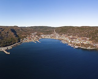
Baie Verte is a town located on the north coast of the island portion of the Canadian province of Newfoundland and Labrador on the Baie Verte Peninsula.

<span class="mw-page-title-main">Trinity, Newfoundland and Labrador</span> Town in Newfoundland and Labrador, Canada

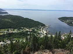
Trinity is a small town located on Trinity Bay in Newfoundland and Labrador. The town contains a number of buildings recognized as Registered Heritage Structures by the Heritage Foundation of Newfoundland and Labrador.

<span class="mw-page-title-main">Tilt Cove</span> Town in Newfoundland and Labrador, Canada

Tilt Cove is a town located southeast of Baie Verte on Notre Dame Bay and was founded in 1813. With an official population of 5 at the 2021 census, Tilt Cove is known as "Canada's smallest town." A source of gold, copper, and zinc ores, Tilt Cove was the site of the first mine in Newfoundland. The Tilt Cove mine opened in 1864 and "was soon employing several hundred men at good wages". Postal service was established in 1869.

Garden Cove is a local service district and designated place in the Canadian province of Newfoundland and Labrador. It is southeast of Swift Current. The residents of Sound Island moved without government assistance during a period around 1953. They moved to the mainland into Garden Cove and surrounding communities. Today Garden Cove has an active close community. There is a tour boat, Merasheen which is part of the Woody Island Resort hotel which gives people a Newfoundland outport experience. Garden Cove has hiking trails passing by Big Rock Hill and Placentiamans Point. There is an inshore fishery operating there. Some species caught are lobster, cod, mackerel, herring, crab, scallops, mussels, flounder and trout. Late in summer Tuna chase bill fish just off shore.

<span class="mw-page-title-main">Rattling Brook, Newfoundland and Labrador</span> Local service district / designated place in Newfoundland and Labrador, Canada

Rattling Brook is a local service district and designated place in the Canadian province of Newfoundland and Labrador. It is in the north-central portion of the island of Newfoundland near Baie Verte and Springdale. Formerly a fishing village, its main residents are retirees and seasonal tourists.

<span class="mw-page-title-main">Nipper's Harbour</span> Town in Newfoundland and Labrador, Canada

Nipper's Harbour is a town located on the east coast of the Baie Verte Peninsula of Newfoundland in the Canadian province of Newfoundland and Labrador. This incorporated community of 85 people is located on a rocky inlet that combines Nipper's Harbour and Noble's Cove, and where the primary industry is the inshore fishery. The town is approximately 58 km from Baie Verte.

<span class="mw-page-title-main">North West River</span> Town in Newfoundland and Labrador, Canada

North West River is a small town located in central Labrador. Established in 1743 as a trading post by French Fur Trader Louis Fornel, the community later went on to become a hub for the Hudson's Bay Company and home to a hospital and school serving the needs of coastal Labrador. North West River is the oldest modern settlement in Labrador.

Route 410, also known as Dorset Trail, is an 89.9-kilometre-long (55.9 mi) north-south highway on the northern coast of Newfoundland in the Canadian province of Newfoundland and Labrador. It leads from Sheppardville, at Route 1, to a dead end in Fleur de Lys, Newfoundland and Labrador. Route 410 serves as the primary roadway access on-and-off the Baie Verte Peninsula. Baie Verte is the most populous community along the route.

<span class="mw-page-title-main">Coachman's Cove</span> Town in Newfoundland and Labrador, Canada

Coachman's Cove is a town in the Canadian province of Newfoundland and Labrador. The town had a population of 111 in the Canada 2021 Census.

Fleur de Lys is a town in the Canadian province of Newfoundland and Labrador. The town had a population of 207 in the Canada 2021 Census. Fleur de Lys is located approximately 26km north of Baie Verte.

Harbour Round is a designated place in the Canadian province of Newfoundland and Labrador. It is east of Baie Verte.

<span class="mw-page-title-main">Roberts Arm, Newfoundland and Labrador</span> Town in Newfoundland and Labrador, Canada

Roberts Arm is a small town located near Crescent Lake, Newfoundland and Labrador, Canada in Division No. 8, Newfoundland and Labrador. It is found on the northern part of Newfoundland. Roberts Arm boasts of its Lake Monster, Cressie, which is claimed to be living in Crescent Lake. Recent years saw the development of a majestic hiking trail which encompasses the end of the lake nearest to the community, Hazelnut Adventure Trail.

Route 411, also known as Purbeck's Cove Road, is a 27.7-kilometre-long (17.2 mi) east–west highway on the Baie Verte Peninsula of Newfoundland in the Canadian province of Newfoundland and Labrador. It connects the town of Westport, along with the community of Purbeck's Cove, with Route 410, serving as the only road access to these aforementioned settlements.

Route 412, also known as Seal Cove Road, is a 13.5-kilometre-long (8.4 mi) east–west highway on the Baie Verte Peninsula of Newfoundland in the Canadian province of Newfoundland and Labrador. It connects the town of Seal Cove, along the community of Wild Cove, with Baie Verte and Route 410.

Route 419, also known as Wild Cove Road, is a short 12.0-kilometre-long (7.5 mi) north–south highway on the Baie Verte Peninsula of Newfoundland in the Canadian province of Newfoundland and Labrador. It connects the community of Wild Cove with the town of Baie Verte via Route 412, serving as the only road access to Wild Cove. There are no other major intersections or communities of any kind along the entire length of Route 419, with the highway being winding and curvy as it traverses very hilly terrain. As with most highways in Newfoundland and Labrador, the entire length of Route 419 is a two-lane highway.

Wild Cove is a local service district and designated place in the Canadian province of Newfoundland and Labrador. It is on the Baie Verte Peninsula of the island of Newfoundland.

References

  1. 1 2 "Population and dwelling counts: Canada, provinces and territories, census divisions and census subdivisions (municipalities), Newfoundland and Labrador". Statistics Canada. February 9, 2022. Retrieved March 15, 2022.
  2. "Bear Aware: Working in Bear Country (English) | St. John Ambulance Canada". www.sja.ca. Retrieved 2022-09-30.