
Gambo is a town and designated place in the Canadian province of Newfoundland and Labrador. It is in the northeastern portion of the island of Newfoundland on Freshwater Bay. It is in Division No. 7.
Appleton is a town in the northeastern part of Newfoundland in the province of Newfoundland and Labrador, Canada.

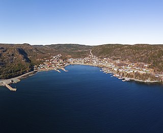
Lawn,, is a town located at the tip of the Burin Peninsula on Newfoundland's South coast, Newfoundland and Labrador. Lawn is spread around a small harbour in a relatively lush valley. According to one local tradition it was this lushness that inspired Captain James Cook to name the place Lawn Harbour. But it has also been speculated that a Frenchman named the community after a doe caribou that he spotted there.
Port Kirwan is a small incorporated fishing community located on the southern shore of the Avalon Peninsula, Newfoundland, Canada.

Sandy Cove is a town located on the Eastport Peninsula in Newfoundland and Labrador, Canada. It is located on Newman Sound, which is part of Bonavista Bay. It had a population of 120 in the 2021 census.

Stephenville Crossing is a town in the Canadian province of Newfoundland and Labrador. It is on the island of Newfoundland at the easternmost limit of Bay St. George.

Change Islands is an outport community in the Canadian province of Newfoundland and Labrador.

The Town of Cape Broyle is an incorporated community located on the Avalon Peninsula in Newfoundland and Labrador, Canada. During King William's War, the village was destroyed in the Avalon Peninsula Campaign.

Campbellton is a small lumbering and fishing community located on the island of Newfoundland at Indian Arm, Notre Dame Bay. The community was originally named Indian Arm due to a Beothuk village located on the nearby Indian Arm River. It was renamed to Campbellton in honor of the sawmill manager John Campbell.
Massey Drive is a Canadian town located on the west coast of the island of Newfoundland in the province of Newfoundland and Labrador. Its name is derived from the original road through the town, named Massey Drive, which in turn is named after Vincent Massey, former Governor General of Canada (1952–59). It is adjacent to the city of Corner Brook, from which it seceded in 1971. It is primarily a residential area.
Baytona is a small rural community found in Newfoundland and Labrador. It is situated off of Route 340, which runs from Lewisporte to Twillingate island, aptly named "Road to the Isles". A bay separates Baytona from a neighboring town called Birchy Bay. The first settlers of Baytona were fishermen, with women mainly staying home to raise children; however, with a depletion in cod stocks and lobsters, there was a shift away from the fishing industry.
Duntara is a town located north west of Catalina, Newfoundland and Labrador. Duntara was an Incorporated Community on October 21, 1961.
Purcell's Harbour is a local service district and designated place in the Canadian province of Newfoundland and Labrador. It is on the southern Twillingate island, about 4 km (2.5 mi) outside the town of Twillingate, near the community of Little Harbour.

LaScie is a town in the Canadian province of Newfoundland and Labrador. The town had a population of 820 in the Canada 2021 Census, down from 872 in 2016.
Middle Arm is a village in the Canadian province of Newfoundland and Labrador. It is located on the northern shore of an inlet of Notre Dame Bay in the north-central part of Newfoundland.
Ming's Bight is a town in the Canadian province of Newfoundland and Labrador. The town had a population of 298 in 2021 Census, down from 319 in the Canada 2016 Census.

Birchy Cove is a local service district and designated place in the Canadian province of Newfoundland and Labrador.
Roddickton-Bide Arm is a town located in the northern peninsula of the island of Newfoundland within the province of Newfoundland and Labrador. It was formed on January 1, 2009 through the amalgamation of the former towns of Roddickton and Bide Arm.
Goobies is a local service district and designated place in the Canadian province of Newfoundland and Labrador.
