Stephenville, Newfoundland and Labrador

Last updated

Stephenville
Town
Stephenville Overlook.jpg
Overlooking the town of Stephenville
Stephenville.gif
Canada Newfoundland location map.svg
Red pog.svg
Stephenville
Location of Stephenville in Newfoundland
Coordinates: 48°33′N58°34′W / 48.550°N 58.567°W / 48.550; -58.567
Country Flag of Canada (Pantone).svg  Canada
Province Flag of Newfoundland and Labrador.svg  Newfoundland and Labrador
Incorporated1952
Government
  MayorTom Rose [1]
  Governing bodyStephenville Town Council
   MHA Tony Wakeham (PC)
   MP Gudie Hutchings (Lib)
Area
  Total35.69 km2 (13.78 sq mi)
Elevation
0 - 74 m (0 - 243 ft)
Population
 (2021) [1]
  Total6,540
  Density185.6/km2 (481/sq mi)
  [2]
Time zone UTC-3:30 (Newfoundland Time)
  Summer (DST) UTC-2:30 (Newfoundland Daylight)
Postal code span
A2N
Area code 709
Telephone Exchange 643, 283, 214, 649, 641 and 721
Median Family Income*$61,184
NTS Map012B10
GNBC CodeAAXZD
Highways NL Route 460.svg Route 460
NL Route 490.svg Route 490
Website Town of Stephenville official website
  • Median income in 2015 - All census economic families ($)

Stephenville (Canada 2021 Census population 6,540) [2] is a town in Newfoundland and Labrador, Canada, on the west coast of the island of Newfoundland.

Contents

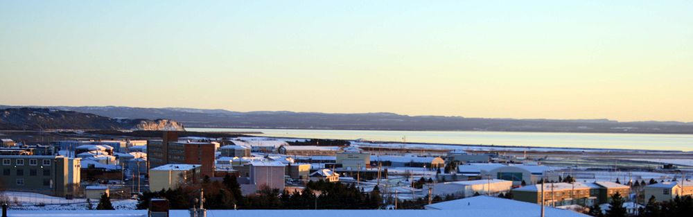
The town functions as a local service centre for the southwestern part of the island, serving a direct population of 35,000 people from surrounding areas and over 100,000 people along the entire southwestern coast of the island. [3]

The primary employer in the town was a paper mill, which closed in 2005.

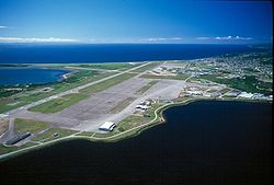
Stephenville has a modern 40-bed hospital (built in 2003), schools, grocery stores, a movie theatre, four banks, an International Airport (Stephenville International Airport, CYJT, now named Dymond International Airport), year round ice free sea port (Port Harmon), and many government institutions. The provincial community college system, College of the North Atlantic, is headquartered in Stephenville and maintains a campus there for students from the southwestern region of the island. The Newfoundland and Labrador Public Library system is also headquartered in Stephenville. [4] A provincial minimum/medium security facility was established in 1978 and provides core programs for federal and provincial offenders at the West Coast Corrections Centre (W.C.C.C) [5]

History

The Stephenville area was formerly known as the Acadian village, between 1848 and 1870. The populace of the village consisted of Roman Catholics who eked out a living, farming and fishing. The town's population continued to grow because of the stable economy. It was also formerly home to Ernest Harmon AFB, which was operated by the United States Army Air Forces and later the United States Air Force from 1941 to 1966.

The base precipitated an economic boom of sorts on Newfoundland's southwest coast during the 1940s. Corner Brook to the northeast had been considered the major population center for the region, given its industrial base and nearby recreational opportunities in the Humber River. With the massive investment of the Government of the United States in the base, the Stephenville and St. George's Bay area began to flourish. The village of Stephenville grew from a hamlet of several hundred people with no paved streets, sidewalks, water or sewage system in 1941 into a modern town of over 5,000 by the mid-1950s. By the time Ernest Harmon AFB closed in 1966, the town had more than doubled in size, partly as a result of the provincial government's forced resettlement policy toward residents of outports.

After the base was closed, the facility was turned over to the federal government which then provided it to the provincial government to diversify the local community.

The facility included the air field, which has two runways (10,000 ft x 200 ft, 4,000 ft x 150 ft) and numerous buildings which are operated as the Stephenville International Airport. An abandoned USAF Pinetree Line radar site is located on nearby Table Mountain, north of the town. The town uses many former USAF structures for housing, recreation and entertainment.

In 2005, Abitibi closed the town's pulp and paper mill. At the time of closure the mill had approximately 300 full-time and part-time employees. [6] [7] [8] [9] [10]

Transportation

The Stephenville International Airport, formerly Ernest Harmon AFB, serves a small portion of the west coast of the island; weekly summer air service is offered to Toronto Pearson with Sunwing Airlines, twice weekly international flights are offered to Saint-Pierre et Miquelon, France, in February, June and August with Air Saint Pierre,

Main Street, Stephenville Main Street Stephenville.jpg
Main Street, Stephenville

Daily intraprovincial bus service connecting to major population centres and ferry terminals across the island is provided by DRL Coachlines. Dedicated bus service between Stephenville and Corner Brook is provided by Eddy's Bus Services. Dedicated bus service between Stephenville and Port aux Basques is provided by Gateway Bus Service.

Three taxi companies serve the town: Crown Taxi, Blue Bird Taxi, and United Class Cabs.

The town is located 15 kilometres northwest of the Trans-Canada Highway, and is accessible using Provincial Highway Routes 490 and 460.

Rail service to the town, as well as all of Newfoundland, was discontinued by Terra Transport in 1988.

The density of the town core, and its flat topography, permit residents to enjoy outdoor activities such as walking, bicycling, roller blading, and cross-country skiing.

Stephenville at Night Stephenville at Night.jpg
Stephenville at Night

Education

The first educational institution in the Bay St. George area was the Roman Catholic Church. Bishop John T. Mullock established the first church of the Roman Catholic faith at Sandy Point in 1848 when the population of the area was about 2000. Father Belenger was the first priest in the St. Georges Bay area from 1850 to 1868. Father Sears, then priest in the area, established a church in the growing town of Stephenville. In 1884, there were four Catholic schools in the parish, one at Sandy Point, one at the Highlands, one at Port aux Basques and one at Campbell's Creek.

Stephenville High School, formerly St. Stephen's High School, in Stephenville, Newfoundland and Labrador Stephenville High School.JPG
Stephenville High School, formerly St. Stephen's High School, in Stephenville, Newfoundland and Labrador

Today, Stephenville is served by four schools: Stephenville Primary, Stephenville Elementary and Stephenville Middle Schools, which are feeder schools for Stephenville High School, SHS also takes in students from St. Thomas Aquinas School in Port-au-Port East.

Stephenville is also home to the Bay St. George campus of College of the North Atlantic (CNA), which is Newfoundland and Labrador's public college system. The provincial Headquarters for CNA is located in the D.S.B Fowlow Building of the campus.

Western College is also located in Stephenville. Formerly known as CompuCollege, the Western College is an affiliate of Eastern College. [11]

Geography

Stephenville Aerial View Stephenville2.jpg
Stephenville Aerial View

The town is located on the northeast coast of Bay St. George in southwestern Newfoundland, and on the Atlantic Ocean. It is situated on a small plateau and surrounded by the Long Range Mountains and Lewis Hills on either side. The downtown area lies to the north of the Stephenville International Airport, and the rest of the town expands primarily to the northwest.

The town is bisected by Blanche Brook, a small river which runs roughly north to south before meeting Warm Brook, which flows roughly east to west, before both empty in Bay St. George. The original town of Stephenville is situated on the west side of the brook while the east side consists of the area which was once part of Ernest Harmon Air Force Base. There are 4 bridges which span Blanche Brook: Hansen Highway Bridge, Blanche Brook Bridge (Main Street), Columbus Bridge (Minnesota Drive) and the newest West Street Bridge built after the 2005 flood. 3 smaller bridges span Warm Brook, located at: Mississippi Drive, Carolina Avenue and Connecticut Drive. Another waterway, Gaudon's Brook, forms the western border with Kippens.

The brooks have been used to create a greenbelt/park area that extends through the centre of town, including Blanche Brook Park which was constructed following the destruction of a neighbourhood which formerly occupied the same space. [12]

Climate

Stephenville has a maritime-influenced humid continental climate (Köppen Dfb). While continental patterns dominate with vast seasonal differences and extremely snowy winters, seasonal lag is prevalent as a result of the seawater warming slowly. As a result, summer normals peak in August, with September being warmer than June in spite of the rapidly descending sun strength. Winters are dominated by the high snowfall, but also can see rainy spells during milder weather, which can occur year-round.

Climate data for Stephenville (Stephenville International Airport, normals from 1981−2010)
MonthJanFebMarAprMayJunJulAugSepOctNovDecYear
Record high humidex 15.013.019.526.028.836.135.834.036.128.024.718.636.1
Record high °C (°F)14.6
(58.3)
12.7
(54.9)
19.7
(67.5)
23.8
(74.8)
27.2
(81.0)
30.0
(86.0)
30.6
(87.1)
29.9
(85.8)
29.1
(84.4)
22.4
(72.3)
20.6
(69.1)
16.1
(61.0)
30.6
(87.1)
Mean daily maximum °C (°F)−2.4
(27.7)
−2.6
(27.3)
0.6
(33.1)
6.4
(43.5)
11.9
(53.4)
16.4
(61.5)
20.2
(68.4)
20.6
(69.1)
16.7
(62.1)
10.8
(51.4)
5.6
(42.1)
0.7
(33.3)
8.7
(47.7)
Daily mean °C (°F)−6.0
(21.2)
−6.7
(19.9)
−3.5
(25.7)
2.6
(36.7)
7.6
(45.7)
12.1
(53.8)
16.4
(61.5)
16.7
(62.1)
12.8
(55.0)
7.4
(45.3)
2.7
(36.9)
−2.4
(27.7)
5.0
(41.0)
Mean daily minimum °C (°F)−9.4
(15.1)
−10.7
(12.7)
−7.6
(18.3)
−1.3
(29.7)
3.2
(37.8)
7.8
(46.0)
12.6
(54.7)
12.8
(55.0)
8.9
(48.0)
4.0
(39.2)
−0.2
(31.6)
−5.3
(22.5)
1.2
(34.2)
Record low °C (°F)−26.1
(−15.0)
−29.5
(−21.1)
−29.2
(−20.6)
−15.6
(3.9)
−7.1
(19.2)
−1.1
(30.0)
3.5
(38.3)
2.2
(36.0)
−0.7
(30.7)
−5.6
(21.9)
−14.9
(5.2)
−20.0
(−4.0)
−29.5
(−21.1)
Record low wind chill −38−41−38−26−13000−4−10−22−36−41
Average precipitation mm (inches)124.6
(4.91)
105.3
(4.15)
86.2
(3.39)
77.7
(3.06)
97.4
(3.83)
104.1
(4.10)
118.4
(4.66)
130.4
(5.13)
127.6
(5.02)
126.9
(5.00)
118.4
(4.66)
123.4
(4.86)
1,340.4
(52.77)
Average rainfall mm (inches)28.9
(1.14)
27.2
(1.07)
36.9
(1.45)
61.5
(2.42)
94.0
(3.70)
104.1
(4.10)
118.4
(4.66)
130.4
(5.13)
127.5
(5.02)
124.0
(4.88)
93.8
(3.69)
48.6
(1.91)
995.3
(39.19)
Average snowfall cm (inches)113
(44)
90
(35)
54
(21)
17
(6.7)
3
(1.2)
0
(0)
0
(0)
0
(0)
0
(0)
3
(1.2)
26
(10)
86
(34)
393
(155)
Average precipitation days (≥ 0.2 mm)26.121.817.715.314.914.315.215.215.719.020.825.1221.2
Average rainy days (≥ 0.2 mm)5.24.66.410.814.414.315.215.215.718.614.58.1143.1
Average snowy days (≥ 0.2 cm)24.720.414.97.01.20.00.00.00.11.59.921.6101.4
Mean monthly sunshine hours 41.973.3116.7141.7205.2204.2206.2201.6145.7114.150.126.61,527.3
Percent possible sunshine 15.425.631.734.643.542.442.445.438.533.918.010.231.8
Source: Environment Canada [13]
Stephenville town.JPG
Stephenville Cityscape

Demographics

Historical population
YearPop.±%
1901643    
1911 826+28.5%
1920817−1.1%
1935926+13.3%
19515,910+538.2%
19616,043+2.3%
197212,500+106.9%
19818,875−29.0%
19867,994−9.9%
19917,621−4.7%
1996 7,764+1.9%
2001 7,109−8.4%
2006 6,588−7.3%
2011 6,719+2.0%
2016 6,623−1.4%
2021 6,540−1.3%
[14] [15] [16] [17] [18]

In the 2021 Census of Population conducted by Statistics Canada, Stephenville had a population of 6,540 living in 3,188 of its 3,412 total private dwellings, a change of

Canada 2016 CensusPopulation % of Total Population
Visible minority group
Source: [1]
South Asian 15
Chinese 00%
Black 15
Filipino 10
Arab 0
Other visible minority15
Total visible minority population60
Aboriginal group
Source: [1]
First Nations 2,510
Métis 60
Inuit 25
Total Aboriginal population2,550
White 4,010
Total population6,623100%

Arts and entertainment

There are numerous bars and pubs operating in Stephenville. The nightlife caters to a diverse population including students attending both College of the North Atlantic and Western College in town. Live entertainment can be found most nights of the week in at least one location. On weekends, DJs are in house at several nightclubs which have also played host to upcoming DJs and performers from cities such as Montreal and Toronto, while other locations host well-known local performers.

Photo of the downtown Stephenville, Newfoundland and Labrador, during the Joe MacNeil Antique and Unique Car Show in July, 2014. Joe MacNeil Antique and Unique Car Show.JPG
Photo of the downtown Stephenville, Newfoundland and Labrador, during the Joe MacNeil Antique and Unique Car Show in July, 2014.

The Bay St. George Folk Arts Council hosts a monthly "Folk Night" at Emile's Pub in downtown Stephenville. The Council promotes local folk artists who work in both the visual arts and in music. [19]

Each summer, the Stephenville Theatre Festival produces high quality professional productions that have attracted visitors from all over Canada and the United States and has been reviewed by publications such as the New York Times. The festival employs upwards of 70 people and is the premiere tourist attraction for the island's southwest coast. [20] The festival performs at the Stephenville Arts and Culture Centre, the second largest of the six arts centres throughout the province. The centre contains a 450-seat main theatre, a 150-seat secondary theatre and an art exhibition area in a building that was once The Service Club on the Ernest Harmon Air Force Base. [21]

Following in Stephenville's strong theatre history and culture, the 2nd Stage Players provide year-round theatre productions put off by locals. The troupe was started by well-known Newfoundland theatre figure Jerry Doyle, who has also initiated acting workshops for youth and adults alike. [22]

The newly renovated Stephenville Cinema is one of only two movie theatres remaining on the west coast of Newfoundland. In its heyday it played host to the likes of Bob Hope, Mae West and Frank Sinatra. Today it hosts big Hollywood titles. [23]

Sports and recreation

The town has numerous indoor and outdoor recreation opportunities. Various schools have public gymnasiums and there are private recreation and fitness facilities in the town and surrounding areas. Stephenville often hosts atlantic, provincial, and regional championships in sports such as curling, hockey, cross-country skiing, soccer, and more.

The International Appalachian Trail has been extended through the area, providing a continuous recreational hiking trail along the Long Range Mountains. The abandoned railway corridors of the Newfoundland Railway have also been designated the "T'railway Provincial Park", providing a level wilderness trail for bicycling and walking.

Within the town itself, the Walk-a-Ways Trail System offers takes pedestrians throughout the town, from the Base, to Port Harmon, into the downtown and to the fossil forest at its northern terminus. The trail links all of Stephenville's recreation areas and complexes including Bike lanes, several soccer fields, baseball and softball diamonds and tennis courts. [24]

The town also has an 18-hole links golf course that was expanded from a 9-hole course in 1999. The course was originally built by the United States Air Force. [25] The former Caribou Club on the base was converted into a 4 sheet curling rink in the 1970s and retains its original name: The Caribou Curling Club. [26]

New Housing Development New Housing Stephenville.jpg
New Housing Development

The Stephenville Dome is home to the "Stephenville Lightning" hockey team of the Central West Senior Hockey league and is the main ice rink for the Bay St. George region, boasting an Olympic-size ice surface and seating for approximately 1,200 patrons. The rink plays host to hockey, figure skating, broomball, general skating, home shows, conventions and concerts. Along with the Pepsi Centre in Corner Brook, the Stephenville Dome co-hosted the 1999 Canada Winter Games and housed events such as figure skating and speedskating. [27] Meanwhile, the Regional Aquatic Centre provides residents with a full range of aquatic activities. This modern swimming facility built in 1995 includes a regulation sized pool, kiddie pool, hot tub, and water slide. [28]

In addition to privately owned fitness centres, the YMCA has a facility in Stephenville. The West Coast Training Centre, a facility featuring numerous amenities such as a gymnasium, weight room, steam room, squash courts, multi-purpose rooms, and office/meeting space was slated to be closed by provincial government as a cost-cutting measure in 2013. The town assumed ownership of the facility shortly afterward and reached an operation agreement with the YMCA. The organization operates a renovated, modern facility with space for sports such as basketball, volleyball, martial arts, as well as fitness classes and include workout space. [29]

Notable people

Notable events

Sister city

See also

Related Research Articles

<span class="mw-page-title-main">Paradise, Newfoundland and Labrador</span> Town in Newfoundland, Canada

Paradise is a town on the Avalon Peninsula in the province of Newfoundland and Labrador, Canada. Paradise is the third largest settlement in the province and is part of the St. John's metropolitan area, the 20th largest metropolitan area in Canada. The town borders the City of St. John's, the City of Mount Pearl, the Town of Portugal Cove-St. Philip's, and the town of Conception Bay South.

Clarenville is a town on the east coast of Newfoundland in the province of Newfoundland and Labrador, Canada. Clarenville was incorporated in 1951. It is located in the Shoal Harbour valley, fronting an arm of the Atlantic Ocean called Random Sound.

Grand Falls-Windsor is a town located in the central region of the island of Newfoundland in the province of Newfoundland and Labrador, Canada, with a population of 13,853 at the 2021 census. The town is the largest in the central region, the sixth largest in the province, and is home to the annual Exploits Valley Salmon Festival. Grand Falls-Windsor was incorporated in 1991, when the two former towns of Grand Falls and Windsor amalgamated.

<span class="mw-page-title-main">Corner Brook</span> City in Newfoundland and Labrador, Canada

Corner Brook is a city located on the west coast of the island of Newfoundland in the province of Newfoundland and Labrador, Canada. Corner Brook is the fifth largest settlement in Newfoundland and Labrador, and the largest outside the Avalon Peninsula.

<span class="mw-page-title-main">Nain, Newfoundland and Labrador</span> Inuit community in Newfoundland and Labrador, Canada

Nain is the northernmost permanent settlement in the Canadian province of Newfoundland and Labrador, within the Nunatsiavut region, located about 370 km (230 mi) by air from Happy Valley-Goose Bay. The town was established as a Moravian mission in 1771 by Jens Haven and other missionaries. As of 2021, the population is 1,204 mostly Inuit and mixed Inuit-European. Nain is the administrative capital of the autonomous region of Nunatsiavut.

<span class="mw-page-title-main">Conception Bay South</span> Town in Newfoundland and Labrador, Canada

Conception Bay South is a town in the Province of Newfoundland and Labrador, Canada. The town is commonly called CBS.

<span class="mw-page-title-main">Kippens</span> Town in Newfoundland and Labrador, Canada

Kippens is a town located in the province of Newfoundland and Labrador, Canada on the west coast of the island of Newfoundland.

<span class="mw-page-title-main">Ernest Harmon Air Force Base</span> Former Air Force base in Canada

Ernest Harmon Air Force Base is a former United States Air Force base located in Stephenville, Newfoundland and Labrador. The base was built by the United States Army Air Forces in 1941 under the Destroyers for Bases Agreement with the United Kingdom.

<span class="mw-page-title-main">Port au Port Peninsula</span>

The Port au Port Peninsula is a peninsula in the Canadian province of Newfoundland and Labrador. Roughly triangular in shape, it is located on the west coast of the island of Newfoundland.

<span class="mw-page-title-main">Pasadena, Newfoundland and Labrador</span> Town in Newfoundland and Labrador, Canada

Pasadena is an incorporated town located in census division 5 which is in the western portion of Newfoundland, Canada. The suburban community is situated on the shores of Deer Lake at the junction of the North Arm Valley and the Humber Valley.

Piccadilly Slant-Abraham's Cove is a local service district and designated place in the Canadian province of Newfoundland and Labrador. It is located on the island of Newfoundland, along St. George's Bay, on the Port au Port Peninsula. The DPL consists of the fishing villages of Abraham's Cove and Piccadilly.

<span class="mw-page-title-main">Torbay, Newfoundland and Labrador</span> Town in Newfoundland and Labrador, Canada

Torbay is a town located on the eastern side of the Avalon Peninsula in Newfoundland and Labrador, Canada.

<span class="mw-page-title-main">Stephenville International Airport</span> Airport in Newfoundland & Labrador, Canada

Stephenville Dymond International Airport is an airport located 1 nautical mile south southeast of Stephenville, Newfoundland and Labrador, Canada. It was built by the United States Army Air Forces and operated as Ernest Harmon Air Force Base from 1941 to 1966.

Route 1 is a highway in the Canada province of Newfoundland and Labrador, and is the easternmost stretch of the Trans-Canada Highway. Route 1 is the primary east–west road on the island of Newfoundland.

<span class="mw-page-title-main">Postville, Newfoundland and Labrador</span> Town in Newfoundland and Labrador, Canada

Postville is an Inuit town in the north of Labrador, Canada. It had a population of 188 as of 2021. It is located about 40 km (25 mi) inside Kaipokok Bay, 180 km (110 mi) NNE of Happy Valley-Goose Bay. Postville Airport is nearby.

<span class="mw-page-title-main">Stephenville Crossing</span> Town in Newfoundland and Labrador, Canada

Stephenville Crossing is a town in the Canadian province of Newfoundland and Labrador. It is on the island of Newfoundland at the easternmost limit of Bay St. George.

<span class="mw-page-title-main">Resettlement (Newfoundland)</span>

Resettlement in Newfoundland and Labrador terms refers to an organized approach to centralize the population into growth areas. It is used in the current context when referring to a voluntary relocation initiated from isolated communities themselves.

<span class="mw-page-title-main">Newfoundland (island)</span> Island portion of Newfoundland and Labrador, Canada

Newfoundland is a large island situated off the eastern coast of the North American mainland and the western part of the Canadian province of Newfoundland and Labrador, referred to as Labrador.

<span class="mw-page-title-main">Outline of Newfoundland and Labrador</span> Overview of and topical guide to Newfoundland and Labrador

The following outline is provided as an overview of and topical guide to Newfoundland and Labrador.

References

  1. https://www.stephenville.ca/town-hall/staff-directory
  2. 1 2 3 "Population and dwelling counts: Canada, provinces and territories, census divisions and census subdivisions (municipalities), Newfoundland and Labrador". Statistics Canada. February 9, 2022. Retrieved March 15, 2022.
  3. "Catchment area". Stephenville Economic Development Committee. Archived from the original on October 7, 2013.
  4. "Library Office Contacts - Newfoundland & Labrador Public Libraries".
  5. "Institutional Services". 12 December 2019.
  6. "Stephenville mill finished: Abitibi". CBC News Nfld. & Labrador. December 14, 2005. Retrieved October 17, 2019.
  7. "Stephenville still taking hits from mill closure". CBC News Nfld. & Labrador. February 21, 2006. Retrieved October 17, 2019.
  8. "Abitibi mill still unsold". Report on Business. The Globe and Mail. August 9, 2006. Retrieved October 17, 2019.
  9. "Abitibi closures hit Nfld. hard". Report on Business. The Globe and Mail. July 27, 2005. Retrieved October 17, 2019.
  10. "Details of task force on impact of Abitibi closure released". Government of Newfoundland and Labrador. December 19, 2005. Retrieved October 17, 2019.
  11. "Private Training Institution Directory" . Retrieved October 17, 2019.
  12. "What is up with Blanche Brook Park?". The Western Star. Saltwire Network. July 29, 2017. Retrieved October 17, 2019.
  13. "Stephenville A". Canadian Climate Normals 1981–2010. Environment Canada. July 2014. Retrieved July 31, 2014.
  14. Stephenville Municipal Records
  15. , Canada Year Book 1967
  16. , 1996 Census of Canada: Electronic Area Profiles
  17. , Community Profiles from the 2006 Census, Statistics Canada - Census Subdivision
  18. , Population and dwelling counts, for Canada, provinces and territories, and census subdivisions (municipalities), 2011 and 2006
  19. "Bay St. George Folk Arts Council". Stephenville Leisure and Recreation. Retrieved October 17, 2019.
  20. "About Us". Stephenville Theatre Festival. Retrieved October 17, 2019.
  21. "History". Arts and Culture Centres. Retrieved October 17, 2019.
  22. "2nd Stage Players". Stephenville Leisure and Recreation. Archived from the original on April 2, 2013.
  23. Gale, Frank (February 19, 2009). "Former base theatre will open again as Stephenville Cinema". The Western Star. Retrieved October 17, 2019 via PressReader.
  24. "Outdoor Recreation Fields". Town of Stephenville. Retrieved October 18, 2019.
  25. "Harmon Seaside Links" . Retrieved October 18, 2019.
  26. "Caribou Curling Club" . Retrieved October 18, 2019.
  27. "Indoor Recreation Facilities". Town of Stephenville. Retrieved October 18, 2019.
  28. "Welcome". Stephenville Aquatic Centre. Retrieved October 18, 2019.
  29. Gale, Frank (January 8, 2014). "Stephenville mayor hopes YMCA will open this month". The Telegram. Transcontinental Media G.P. Archived from the original on March 3, 2016.
  30. "Abitibi cutting paper production in Ontario and Newfoundland". CBC News. December 14, 2005. Archived from the original on November 7, 2012.
  31. "State of emergency remains in effect in flooded Newfoundland town". The Canadian Press. 2005.
  32. "Stephenville, N.L., awarded Hockey Day in Canada". CBC Sports. December 13, 2005. Archived from the original on July 8, 2007.
  33. https://www.cbc.ca/news/canada/newfoundland-labrador/canada-germany-hydrogen-1.6551250
  34. "Sister Cities". City of Castlegar. Retrieved October 18, 2019.

48°33′N58°34′W / 48.550°N 58.567°W / 48.550; -58.567 (Stephenville)