
Loch is a word meaning "lake" or "sea inlet" in Scottish and Irish Gaelic, subsequently borrowed into English. In Irish contexts, it often appears in the anglicized form "lough". A small loch is called a lochan.

Newfoundland and Labrador is the easternmost province of Canada, in the country's Atlantic region. The province comprises the island of Newfoundland and the continental region of Labrador, having a total size of 405,212 km2 (156,453 sq mi). As of 2024 the population of Newfoundland and Labrador was estimated to be 545,880. The island of Newfoundland is home to around 94 per cent of the province's population, with more than half residing in the Avalon Peninsula. Labrador has a land border with both the province of Quebec, as well as a short border with the territory of Nunavut on Killiniq Island. The French overseas collectivity of Saint Pierre and Miquelon lies about 20 km (12 mi) west of the Burin Peninsula.

Labrador is a geographic and cultural region within the Canadian province of Newfoundland and Labrador. It is the primarily continental portion of the province and constitutes 71% of the province's area but is home to only 6% of its population. It is separated from the island of Newfoundland by the Strait of Belle Isle. It is the largest and northernmost geographical region in the four Atlantic provinces.

Loch Leven is a fresh water loch located immediately to the east of the burgh of Kinross in Perth and Kinross council area, central Scotland. Roughly triangular, the loch is about 6 km (3.7 mi) at its longest. Prior to the canalisation of the River Leven, and the partial draining of the loch in 1826–36, Loch Leven was considerably larger. The drop in water level by 1.4 m reduced the loch to 75% of its former size, and exposed several small islands, as well as greatly increasing the size of the existing ones.

The International Appalachian Trail was originally a hiking trail which ran from Katahdin Woods and Waters National Monument, in Maine, through New Brunswick, to the Gaspé Peninsula of Quebec, after which it followed a ferry route to Newfoundland, and then continued to the northern-easternmost point of the Appalachian Mountains at Belle Isle, Newfoundland and Labrador. As of July 2020, there are widely geographically dispersed IAT-branded walking trails in Greenland, Iceland, Norway, Sweden, Denmark, Scotland, Northern Ireland, Ireland, Isle of Man, Wales, England, Spain, Portugal, and Morocco.
St. George's-Stephenville East is a defunct provincial electoral district for the House of Assembly of Newfoundland and Labrador. Created in 1995 from the districts of St. George's and Stephenville. In 2011, there were 7,861 eligible voters living within the district.
Lomond can refer to any of the following:

Cypress Hills Interprovincial Park is a natural park in Canada straddling the Alberta / Saskatchewan boundary and jointly administered by the two provinces. Located south-east of Medicine Hat in the Cypress Hills, it became Canada's first interprovincial park in 1989.
St. George's Bay - informally referred to as Bay St. George due to its French translation Baie St-George - is a large bay in the province of Newfoundland and Labrador, Canada. It is located on the west coast of the island of Newfoundland and comprises a sub-basin of the Gulf of St. Lawrence. The estimated population of the entire bay is 16,000, based on the demographic data of each community.
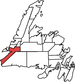
Division No. 4, Subd. B is an unorganized subdivision on St. George's Bay on the island of Newfoundland in Newfoundland and Labrador, Canada. It is in Division No. 4. According to the 2016 Statistics Canada Census:
William Joseph Browne, was a Canadian lawyer, judge and politician. He served in the Newfoundland House of Assembly and the House of Commons of Canada.
Loch Lomond was a community in Newfoundland and Labrador near St. Andrews. It had a population of 67 in 1956.
James Joseph Louis (Jim) Greene was the Newfoundland and Labrador's Opposition Leader from 1960 to 1965 and leader of the Progressive Conservative Party of Newfoundland. He led the party through the 1962 provincial election in which the party increased its seat total in the Newfoundland House of Assembly from 3 to 7, more than doubling them, and its share of the popular vote from 25% to 36%. The result was not enough to prevent the Liberal government of Joey Smallwood from returning to power with a substantial majority government.
Bay St. George South is a local service district and designated place in the Canadian province of Newfoundland and Labrador on the south coast of Bay St. George, a large bay on the west coast of the island of Newfoundland. Bay St. George South consists nine communities, namely Heatherton, Robinsons, Cartyville, McKay's, Jeffrey's, St. David's, St. Fintan's, Lock Leven en Highlands.
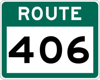
Route 406, also known as Codroy Road, is a highway on the western portion of Newfoundland in the Canadian province of Newfoundland and Labrador. It is a relatively short route, with its eastern terminus at Route 1 in the community of Doyles, and its western terminus at Cape Anguille. The route travels through the scenic Codroy Valley region.
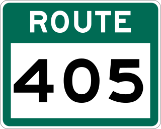
Route 405, also known as Highlands Road, is a 18.0-kilometre-long (11.2 mi) minor highway in the western region of Newfoundland in the Canadian province of Newfoundland and Labrador. The highway begins at a junction with Route 1 and continues to its west terminus, the community of Highlands.
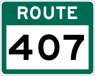
Route 407, also known as St. Andrew's-Searston Road, is a minor highway on the western portion of Newfoundland in the Canadian province of Newfoundland and Labrador. The route's southern terminus is the Trans-Canada Highway in the community of Tompkins, and its northern terminus is in the community of Millville, at an intersection with Route 406. Along with Route 406, Route 407 allows for an extensive view of the Codroy Valley.
