Division No. 8 is a census division on the north coast of the island of Newfoundland in the province of Newfoundland and Labrador, Canada. It has a land area of 9,314.57 km² and had a population of 33,940 at the 2016 census. Its largest communities are the towns of Lewisporte, Springdale, and Twillingate.

Twillingate is a town of 2,121 people located on the Twillingate Islands ("Toulinquet") in Notre Dame Bay, off the north eastern shore of the island of Newfoundland in the province of Newfoundland and Labrador, Canada. The town is about 100 kilometres (62 mi) north of Lewisporte and Gander.
Aspen Cove is a small fishing community in the province of Newfoundland and Labrador, Canada. Formerly called Aspey or Apsey Cove, Aspen Cove was named for the presence of aspen trees in the area. It first appears in the 1857 Census as Apsey Cove with a population of thirteen, all dependent on the salmon fishery. By the 1870s more families moved to Aspen Cove for the cod and lobster fisheries. In the 1921 census the population had reached 104 and the economy had changed from salmon, fur, and agriculture to cod, lobster, and lumbering.

Portugal Cove–St. Philip's is a rural seashore community located on the eastern Avalon Peninsula of Newfoundland in the province of Newfoundland and Labrador, Canada. The town is a bedroom community of the provincial capital of St. John's.

Summerford is a small town on the central coast of Newfoundland in Canada. It is located just off Route 340, along Route 344. The Town of Summerford lies mostly on New World Island in Notre Dame Bay just off the coast of the island of Newfoundland. Strong's Island, which is connected to New World Island by Island Drive, is also a part of the town. Summerford had a population of 805 in 2021, down from 906 in the Canada 2016 Census. It is close to the neighbouring communities of Virgin Arm-Carter's Cove and Cottlesville.

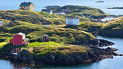
Glovers Harbour, formerly known as Thimble Tickle(s), is an unincorporated community and harbour in the Canadian province of Newfoundland and Labrador. It is located in Notre Dame Bay on the northern coast of the island of Newfoundland. As a local service district, it is led by an elected committee that is responsible for the delivery of certain essential services. It is delineated as a designated place for statistical purposes.

Boyd's Cove, also known as Boyd's Harbour, is a local service district and designated place in the Canadian province of Newfoundland and Labrador that is near Lewisporte. There is an interpretive centre dedicated to the earlier indigenous Beothuk settlement at this location.

Pool's Cove is a community located on the north west side of Fortune Bay, on the South Coast of Newfoundland, Canada. The town had a population of 143 in the 2021 Census.

Campbellton is a small lumbering and fishing community located on the island of Newfoundland at Indian Arm, Notre Dame Bay. The community was originally named Indian Arm due to a Beothuk village located on the nearby Indian Arm River. It was renamed to Campbellton in honor of the sawmill manager John Campbell.
Admirals Beach is a rural community located in Newfoundland and Labrador, Canada.
Noggin Cove is a local service district and designated place in the Canadian province of Newfoundland and Labrador. It is west of Carmanville on the south side of Hamilton Sound. It is said to be named after Noggin Island, about 5 km off its eastern point.
Ladle Cove is a designated place in the Canadian province of Newfoundland and Labrador. It is along the Straight Shore on the island of Newfoundland.
Indian Cove is a local service district and designated place in the Canadian province of Newfoundland and Labrador. It is just off Route 340 on New World Island. It is the last community before crossing the causeway to Twillingate. Before the construction of the causeway, there was a ferry that ran from Indian Cove to Twillingate. There is a hair salon and dog grooming services. Education is provided by New World Island Academy in Summerford and grocery shopping can be done in nearby Twillingate.

Elliston is an incorporated fishing settlement situated on the Bonavista Peninsula of Newfoundland, Canada. Incorporated in 1965, the town of Elliston was once called Bird Island Cove and it is composed of a number of communities, North Side, Noder Cover, Elliston Centre, Elliston Point, Porter's Point, Sandy Cove, The Neck and Maberly. Elliston is known as the Root Cellar Capital of the World and has claimed that title from the 135 root cellars that exist in the community.
Ship Cove-Lower Cove-Jerry's Nose is a local service district and designated place in the Canadian province of Newfoundland and Labrador.

Coachman's Cove is a town in the Canadian province of Newfoundland and Labrador. The town had a population of 111 in the Canada 2021 Census.

Leading Tickles is a town in the Canadian province of Newfoundland and Labrador. In 2021, the town had a population of 296, down from 407 in the Canada 2006 Census. It is located approximately 25 km Northwest of Point Leamington on the shores of Notre Dame Bay. The town boasts spectacular scenery especially in spring and early summer when many icebergs pass just off the coast.
Lushes Bight–Beaumont–Beaumont North is a town on Long Island in Notre Dame Bay in the Canadian province of Newfoundland and Labrador. The town had a population of 169 at the 2021 Census, down from 275 in the 2006 Census.
Norman's Bay is a local service district and designated place in the Canadian province of Newfoundland and Labrador. It is an isolated community at the head of Norman Bay, an extension of Martin Bay. The population of the community was 15 in the 2021 census.
New Harbour is a local service district and designated place in the Canadian province of Newfoundland and Labrador. It is on the east shore of Trinity Bay, along Provincial Route 80. Route 80's intersection with Route 73 is inside New Harbour.