Frederickton is a designated place in the Canadian province of Newfoundland and Labrador.
Contents

Frederickton is a designated place in the Canadian province of Newfoundland and Labrador.
Formerly called Bassett's Harbour, this fishing and lumbering community was named Frederickton after 1901. Early inhabitants came from Fogo Island to use Muddy Hole's resources during the winter season, such as its forest, unoccupied lands, abundant wildlife, and fishing and birding grounds. Muddy Hole first appears in the 1845 Census with a population of 45; by 1857 the population had reached 150. The growth in Muddy Hole was its advantageous location for the seal hunt and cod fishery. By the 1950s Frederickton was a lobster-fishing area with some logging as well. In 1951 the population was 235 and by 1966 it was 346. [1]
The first inhabitants of Frederickton were Church of England and there were a small number of Roman Catholics as well, in the 1840s. In the 1857 Census there was a record of Wesleyans in the community. In 1857 there was a Methodist school and by the early 1900s a Methodist church was constructed in Frederickton. [1]
In 1860 some resident fishermen of Muddy Hole were James Bonnall, George Clark, Richard Hipditch, and Thomas King. [2]
Frederickton is in Newfoundland within Subdivision L of Division No. 8. [3]
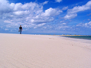
Frederickton is located on the southwest shore of Muddy Hole, north of Carmanville on the point of an open, exposed harbour. The rocky, low stretch of coastline, the shallow waters in the bay and the exposure to harsh weather can be dangerous for boats. For example, the H.M. Mosdell overturned in November 1908 due to strong wind and six men drowned. However, Frederickton's position created an excellent base for the seal hunt and cod fishery which was the basis of its growth and economy. Frederickton is also located close to excellent fishing and birding areas and has agricultural potential. [1]
As a designated place in the 2016 Census of Population conducted by Statistics Canada, Frederickton recorded a population of 221 living in 107 of its 124 total private dwellings, a change of -12.6% from its 2011 population of 253. With a land area of 1.82 km2 (0.70 sq mi), it had a population density of 121.4/km2 (314.5/sq mi) in 2016. [4]
Piccadilly Slant-Abraham's Cove is a local service district and designated place in the Canadian province of Newfoundland and Labrador. It is located on the island of Newfoundland, along St. George's Bay, on the Port au Port Peninsula. The DPL consists of the fishing villages of Abraham's Cove and Piccadilly.
Aspen Cove is a small fishing community in the province of Newfoundland and Labrador, Canada. Formerly called Aspey or Apsey Cove, Aspen Cove was named for the presence of aspen trees in the area. It first appears in the 1857 Census as Apsey Cove with a population of thirteen, all dependent on the salmon fishery. By the 1870s more families moved to Aspen Cove for the cod and lobster fisheries. In the 1921 census the population had reached 104 and the economy had changed from salmon, fur, and agriculture to cod, lobster, and lumbering.

Open Hall-Red Cliffe is a local service district and designated place in the Canadian province of Newfoundland and Labrador.
Tizzard's Harbour is a local service district and designated place in the Canadian province of Newfoundland and Labrador.
Virgin Arm–Carter's Cove is a local service district and designated place on New World Island in the Canadian province of Newfoundland and Labrador. Virgin Arm-Carter's Cove is located approximately 90 km Northwest of Gander in Subdivision H of Division No. 8.
Keels is a small town in the Canadian province of Newfoundland and Labrador, located about 3 kilometres from Duntara. The population of this municipality in the 2016 Canadian National Census was 51. This is down from 61 in 2011 and 73 in 2006. The earlier population figures show it had 85 in 2001, 101 in 1996, 128 in 1991, 115 in 1986, 206 in 1956 and 372 in 1940.
Carmanville is a Canadian community in the province of Newfoundland and Labrador.
Musgrave Harbour is a town and designated place in the Canadian province of Newfoundland and Labrador.
Bauline is a small town in the Canadian province of Newfoundland and Labrador, located on the Avalon Peninsula north of St. John's. As of the 2021 census, it had a population of 412, making it the smallest incorporated community in the St. John's metropolitan area.
Deadman's Bayis a local service district and designated place in the Canadian province of Newfoundland and Labrador. It is on the Straight Shore of Bonavista Bay near the community of Lumsden. The community is located near fishing grounds, contributing to its diversified and successful fishery despite its exposed, sandy coastline and harsh fall storms.
Noggin Cove is a local service district and designated place in the Canadian province of Newfoundland and Labrador. It is west of Carmanville on the south side of Hamilton Sound. It is said to be named after Noggin Island, about 5 km off its eastern point.
Lumsden, formerly known as Cat Harbour, is a community located on the Straight Shore of Newfoundland in Newfoundland and Labrador, Canada, near communities such as Musgrave Harbour and Newtown. Lumsden formerly consisted of two settlements, Lumsden North on the tip of a sandy peninsula and Lumsden South on the main road. Although the harbour in Lumsden is not ideal because it is not sheltered, Lumsden has excellent fishing grounds.
Ladle Cove is a designated place in the Canadian province of Newfoundland and Labrador. It is along the Straight Shore on the island of Newfoundland.
Harbour Round is a designated place in the Canadian province of Newfoundland and Labrador. It is east of Baie Verte.
Harry's Harbour is a local service district and designated place in the Canadian province of Newfoundland and Labrador. It is southeast of Baie Verte.
Merritt's Harbour is a local service district and designated place in the Canadian province of Newfoundland and Labrador. It is located near Herring Neck, on New World Island, a few kilometers south of the causeway to Twillingate.
Island Harbour is a designated place in the Canadian province of Newfoundland and Labrador.

Sop's Arm is a local service district and designated place in the Canadian province of Newfoundland and Labrador. The community was formed in the 1930s and 1940s by families moving from surrounding communities, including Jackson's Arm. In the 1950s and 1960s families from nearby Sop's Island moved to Sop's Arm, towing their houses across the channel of water.
Smith's Harbour is a local service district and designated place in the Canadian province of Newfoundland and Labrador.
Caplin Cove-Southport is a local service district and designated place in Trinity Bay in the Canadian province of Newfoundland and Labrador. Caplin Cove-Southport is approximately 50 km from Clarenville.