
Bishop's Falls is a town in the north-central part of the island of Newfoundland in the Canadian province of Newfoundland and Labrador, with a population of 3, 156 at the 2016 census.
Grand Falls-Windsor is a town located in the central region of the island of Newfoundland in the province of Newfoundland and Labrador, Canada, with a population of 14,171 at the 2016 census. The town is the largest in the central region, the fifth largest in the province, and is home to the annual Exploits Valley Salmon Festival. Grand Falls-Windsor was incorporated in 1991, when the two former towns of Grand Falls and Windsor amalgamated.
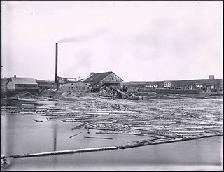
Badger is a town in north-central Newfoundland, Newfoundland and Labrador, Canada on the Exploits River. It supplied pulp and paper for the mills in Grand Falls for many years and was famous for its large spring log drives. The town is located in the interior of the island, twenty miles west of Grand Falls in Division No. 6. Badger was incorporated as a Town on September 30, 1963.

Humber—St. Barbe—Baie Verte was a federal electoral district in Newfoundland and Labrador, Canada, that was represented in the House of Commons of Canada from 1988 to 2015.

The Exploits River is a river in the province of Newfoundland and Labrador, Canada. It flows through the Exploits Valley in the central part of Newfoundland.

The Newfoundland Railway operated on the island of Newfoundland from 1898 to 1988. With a total track length of 906 miles (1,458 km), it was the longest 3 ft 6 in narrow-gauge railway system in North America.
Botwood is a town in north-central Newfoundland, Newfoundland and Labrador, Canada in Census Division 6. It is located on the west shore of the Bay of Exploits on a natural deep water harbour used by cargo ships and seaplanes throughout the town's history. Botwood was the North American terminus for the first transatlantic commercial flights.

Exploits is a provincial electoral district for the House of Assembly of Newfoundland and Labrador, Canada.

Newfoundland Power Inc. is an electric utility owned by Fortis Inc. which is the primary retailer of electric power in the Canadian province of Newfoundland and Labrador. The company was formed by the Royal Securities Corporation of Montreal in 1924 as the Newfoundland Light & Power Company.
Route 1 is a highway in the Canada province of Newfoundland and Labrador, and is the easternmost stretch of the Trans-Canada Highway. Route 1 is the primary east–west road on the island of Newfoundland.

Glovers Harbour, also written as Glover's and formerly known as Thimble Tickle(s), is an unincorporated community and harbour in Notre Dame Bay, on the northern coast of Newfoundland, Canada. It is delineated as a designated place for statistical purposes.

Peterview is a town located in the Exploits Valley area of central Newfoundland and Labrador, Canada, where Peters River empties into the Bay of Exploits, just south of Botwood, off Route 350.
Springdale is a town in Newfoundland and Labrador, Canada, which had a population of 2,971 people in 2016, up from 2,764 in the Canada 2006 Census. The community is located on the Northwestern shores of Hall's Bay in Central Newfoundland, near the mouth of Indian River.
Nova Central School District was a school district headquartered in Gander in the Canadian province of Newfoundland and Labrador. The district had 66 schools located in 50 different communities, and served about 13,000 students, including a significant rural population. The District was formed by the merger of the Lewisporte-Gander and Baie Verte-Central-Connaigre school boards in 2004. The largest school in the district was Gander Academy. The district was replaced by the Newfoundland and Labrador English School District upon provincial amalgamation in 2013.
The Exploits Valley is a valley in the province of Newfoundland and Labrador in the central part of the island of Newfoundland.
Route 350, commonly known as Botwood Highway, is a side highway in Central Newfoundland that leads from the Trans-Canada Highway in Bishop's Falls to Botwood, Point Leamington and Leading Tickles. It is 70.7 kilometres (43.9 mi) in length and contains several side roads to communities located off the route, such as Peterview, and Route 352 that leads to Point of Bay and the Cottrell's Cove-Fortune Harbour area. Route 350-17 branches off in Point Leamington and connects the small community of Pleasantview to the main route. Route 350 continues on from Point Leamington for another 25 km north to Leading Tickles where the road officially ends. Along the way there is another short road connecting Glovers Harbour to the main route as well.

Centreville–Wareham–Trinity is a town in the Canadian province of Newfoundland and Labrador, located on Bonavista Bay. The town had a population of 1,147 in the Canada 2016 Census, down from 1,161 in 2011.

Leading Tickles is a town in the Canadian province of Newfoundland and Labrador. In 2016, the town had a population of 292, down from 407 in the Canada 2006 Census. It is located approximately 25 km Northwest of Point Leamington on the shores of Notre Dame Bay. The town boasts spectacular scenery especially in spring and early summer when many icebergs pass just off the coast.

Roberts Arm is a small town located near Crescent Lake, Newfoundland and Labrador, Canada in Division No. 8, Newfoundland and Labrador. It is found on the northern part of Newfoundland. Roberts Arm boasts of its Lake Monster, Cressie, which is claimed to be living in Crescent Lake. Recent years saw the development of a majestic hiking trail which encompasses the end of the lake nearest to the community, Hazelnut Adventure Trail.
Lockesporte, also spelled Lockesport or Lockport and originally known as Lock's Harbour, was a fishing village and logging community on the eastern coast of Seal Bay, within the much larger Notre Dame Bay, Newfoundland, Canada.
