Related Research Articles
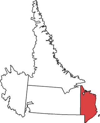
Cartwright-L'Anse au Clair is a provincial electoral district for the House of Assembly of Newfoundland and Labrador, Canada. As of 2011, there are 3,131 eligible voters living within the district.

George Cartwright was an English army officer and a trader and explorer in Newfoundland Colony. His name is borne by Cartwright, a settlement at the entrance to Sandwich Bay.

Cartwright is a community located on the eastern side of the entrance to Sandwich Bay, along the southern coast of Labrador in the province of Newfoundland and Labrador, Canada. It was incorporated in 1956.
Woody Point is a town located in the heart of Gros Morne National Park, on the western coast of Newfoundland. Situated on Bonne Bay, the Town of Woody Point encompasses three areas: Curzon Village, Woody Point and Winterhouse Brook. It has a total population of 244 residents. Woody Point is a Registered Heritage District and has a waterfront with many heritage buildings and four Registered Newfoundland and Labrador Heritage Structures. The community is served by Route 431.
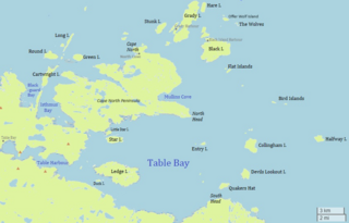
Table Bay is a natural bay and former community on the coast of Labrador in the province of Newfoundland and Labrador, Canada. It drains into the Labrador Sea to the east.
Muddy Bay is a former settlement on the coast of Labrador in the province of Newfoundland and Labrador, Canada. It was located on the shore of Muddy Bay, a small bay of Favorite Tickle. Muddy Bay was deeply impacted by the 1918 Influenza Pandemic which resulted in the deaths of 21% of its total population of 320 at the time. The Labrador Public School opened by the Anglican Church in 1920 as part of the Canadian Indian residential school system was primarily occupied by orphaned children due to the casualties.
Eddies Cove West is a local service district and designated place in the Canadian province of Newfoundland and Labrador.
Lodge Bay is a local service district and designated place in the Canadian province of Newfoundland and Labrador. It is on the southeast coast of Labrador. Encompassing a population of less than one hundred residents, the community has uniquely evolved from both early European colonization of Labrador, and the inimitable patterns of land and resource use by the migratory Inuit population. The name Lodge Bay originated from the title Ranger Lodge, which was the name given to the area by trader and explorer, Captain George Cartwright in the late 18th century. "Ranger" was the name of the wooden-mercantile ship Cartwright used to trade, map and explore the Labrador coast, while "Lodge" was the name given to English hunting camps in Great Britain at that time.

La Poile Bay is a natural bay in Newfoundland, Canada, in the southwestern area of the island, off the south coast. It subdivides into Northeast Arm and North Bay. The settlement of La Poile is located on the bay.

Ingornachoix Bay is a natural bay on the island of Newfoundland in the province of Newfoundland and Labrador, Canada. It is located approximately mid-way along the western shore of the Great Northern Peninsula. Home to three villages, Port aux Choix, Port Saunders and Hawkes Bay.

Good Bay is a natural bay on the island of Newfoundland in the province of Newfoundland and Labrador, Canada. Good Bay is located on the southern part of St. John Harbor.
Well Bay is a natural bay near St. John Harbor, off the island of Newfoundland in the province of Newfoundland and Labrador, Canada. It is located on the southern part of St. John Harbor, in a bay called Good Bay. Well Bay is a natural indentation in the northern part of Good Bay. The middle of Well Bay has depths of 9.1–10.9 m. About 0.5 mile northeast of Well Bay, there are two beacons.
Barred Bay is a natural bay near St. John Harbor, off the island of Newfoundland in the province of Newfoundland and Labrador, Canada. It is located on the southern part of St. John Harbor, in a bay called Good Bay. Well Bay is a natural indentation in the northern part of Good Bay, at its eastern end. In the western part of Barred Bay, there is an islet called Sheep Islet, which is 1.5 m high.
Muddy Bay is a bay on the coast of Labrador in the province of Newfoundland and Labrador, Canada. It is a small eastern inlet of Favorite Tickle, a strait connecting Sandwich Bay in the south with the Atlantic Ocean in the north. The bay has a maximum depth between 18 and 20 meters.
Blackguard Bay is a natural bay on the coast of Labrador in the province of Newfoundland and Labrador, Canada. The closest inhabited place is Cartwright.
Pottles Bay is a natural bay on the coast of Labrador in the province of Newfoundland and Labrador, Canada. It is fed by the Northwest Brook basin and drains into the Labrador Sea.

Division No. 1, Subdivision G is an unorganized subdivision on the Avalon Peninsula in Newfoundland and Labrador, Canada. It is in Division 1 and contains the unincorporated communities of Baccalieu Island, Besom Cove, Bradley's Cove, Burnt Point, Caplin Cove, Daniel's Cove, Grates Cove, Gull Island, Job's Cove, Kingston, Long Beach, Lower Island Cove, Low Point, Northern Bay, Ochre Pit Cove, Red Head Cove, Riverhead, Smooth Cove and Western Bay.
Division No. 1, Subdivision L is an unorganized subdivision on the Avalon Peninsula in Newfoundland and Labrador, Canada. It is in Division 1 and contains the unincorporated communities of Bareneed, Black Duck Pond, Blow Me Down, Coley's Point South, Hibb's Cove, Pick Eyes, Port de Grave, Ship Cove and The Dock
North River is a settlement in the Canadian province of Newfoundland and Labrador. It is located on the northern bank of the North River, about 10 miles north of the town of Cartwright, at the river's outlet into Sandwich Bay.
Paradise River is a community on the southwestern coastline of Sandwich Bay in southeastern Labrador, Canada.
References
- ↑ "Toponymic and Cartographic Research Conducted for the Labrador Métis Nation" (PDF). Archived from the original (PDF) on 2016-08-11.
- ↑ United States Hydrographic Office; Davenport, Richard G. (1884). Newfoundland and Labrador: The coast and banks of Newfoundland and the coast of Labrador, from Grand Point to the Koksoak River, with the adjacent islands and banks (Public domain ed.). Govt. print. off. pp. 523–. Retrieved 20 November 2011.
53°34′01″N57°10′01″W / 53.567°N 57.167°W
| | This Labrador location article is a stub. You can help Wikipedia by expanding it. |