Afro-Eurasia

Last updated
Afro-Eurasia
Afro-Eurasia (orthographic projection) political.svg
Afro-Eurasia (orthographic projection) blank.svg
LocationAfricaEurasia.png
Area84,980,532 km2 (32,811,167 sq mi)
Population6.7 billion (2019)
Population density78.5/km2 (204.2/sq mi)
Demonym Afro-Eurasian, Eurafrasian
Countries147
Dependencies17
Time zones UTC−01:00UTC+12:00
Part of Earth

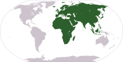
Afro-Eurasia (also Afroeurasia and Eurafrasia) is a landmass comprising the continents of Africa, Europe, and Asia. The terms are compound words of the names of its constituent parts. Afro-Eurasia has also been called the "Old World", in contrast to the "New World" referring to the Americas.

Contents

Afro-Eurasia encompasses 84,980,532 km2 (32,811,167 sq mi), 57% of the world's land area, and has a population of approximately 6.7 billion people, roughly 86% of the world population. Together with Australia, it comprises the vast majority of land in the world's Eastern Hemisphere. The Afro-Eurasian mainland is the largest and most populous contiguous landmass on Earth.

The following terms are used for similar concepts:

Geology

Although Afro-Eurasia is typically considered to comprise two or three separate continents, it is not a proper supercontinent. Instead, it is the largest present part of the supercontinent cycle. [3]

Past

The oldest part of Afro-Eurasia is probably the Kaapvaal Craton, which together with Madagascar and parts of India and western Australia formed part of the first supercontinent Vaalbara or Ur around 3 billion years ago. It has made up parts of every supercontinent since. At the breakup of Pangaea around 200 million years ago, the North American and Eurasian Plates together formed Laurasia while the African Plate remained in Gondwana, from which the Indian Plate split off. Upon impact with the Eurasian Plate, the Indian Plate created southern Asia around 50 million years ago and began the formation of the Himalayas. Around the same time, the Indian Plate also fused with the Australian Plate.

The Arabian Plate broke off of Africa around 30 million years ago and impacted the Iranian Plate between 19 and 12 million years ago during the Miocene, ultimately forming the Alborz and Zagros chains of Iranian Plate. After this initial connection of Afro-Eurasia, the Betic corridor along the Gibraltar Arc closed a little less than 6 million years ago in the Messinian, fusing northwest Africa and Iberia together. This led to the nearly complete desiccation of the Mediterranean Basin, the Messinian salinity crisis. Eurasia and Africa were then again separated with the Zanclean Flood around 5.33 million years ago refilling the Mediterranean Sea through the Strait of Gibraltar.

Present

Today, the Eurasian Plate and African Plate dominate their respective continents. However, the Somali Plate covers much of eastern Africa, creating the East African Rift. In the eastern Mediterranean, the Aegean Sea Plate, Anatolian Plate and Arabian Plate also form a boundary with the African Plate, which incorporates the Sinai Peninsula, Gulf of Aqaba and the coastal Levant via the Dead Sea Transform. Eurasia also includes the Indian Plate, Burma Plate, Sunda Plate, Yangtze Plate, Amur Plate and Okhotsk Plate, with the North American Plate incorporating the Chukotka Autonomous Okrug in the Russian Far East.

Conventionally, Africa is joined to Eurasia only by a relatively narrow land bridge (which has been split by the Suez Canal at the Isthmus of Suez) and remains separated from Europe by the straits of Gibraltar and Sicily.

Future

Paleogeologist Ronald Blakey has described the next 15 to 100 million years of tectonic development as fairly settled and predictable. [4] In that time, Africa is expected to continue drifting northward. It will close the Strait of Gibraltar, [5] quickly evaporating the Mediterranean Sea. [6] No supercontinent will form within the settled time frame, however, and the geologic record is full of unexpected shifts in tectonic activity that make further projections "very, very speculative". [4] Three possibilities are known as Novopangaea, Amasia, and Pangaea Proxima. [7] In the first two, the Pacific closes and Africa remains fused to Eurasia, but Eurasia itself splits as Africa and Europe spin towards the west; in the last, the trio spin eastward together as the Atlantic closes, creating land borders with the Americas.

Extreme points

This is a list of the points that are farther north, south, east or west than any other location as well as the highest and lowest elevations on Afro-Eurasia.

Mainland

Including islands


The 180th meridian passes through Asia, meaning that these points are in the Western Hemisphere.

Elevation

• Highest Point – Mount Everest or Qomolangma, China and Nepal

• Lowest Point (on land) – Shores of the Dead Sea, between Israel and Jordan

See also

Related Research Articles

<span class="mw-page-title-main">Supercontinent</span> Landmass comprising more than one continental core, or craton

In geology, a supercontinent is the assembly of most or all of Earth's continental blocks or cratons to form a single large landmass. However, some geologists use a different definition, "a grouping of formerly dispersed continents", which leaves room for interpretation and is easier to apply to Precambrian times. To separate supercontinents from other groupings, a limit has been proposed in which a continent must include at least about 75% of the continental crust then in existence in order to qualify as a supercontinent.

<span class="mw-page-title-main">Laurasia</span> Northern landmass that formed part of the Pangaea supercontinent

Laurasia was the more northern of two large landmasses that formed part of the Pangaea supercontinent from around 335 to 175 million years ago (Mya), the other being Gondwana. It separated from Gondwana 215 to 175 Mya during the breakup of Pangaea, drifting farther north after the split and finally broke apart with the opening of the North Atlantic Ocean c. 56 Mya. The name is a portmanteau of Laurentia and Asia.

<span class="mw-page-title-main">Tethys Ocean</span> Prehistoric ocean between Gondwana and Laurasia

The Tethys Ocean, also called the Tethys Sea or the Neo-Tethys, was a prehistoric ocean during much of the Mesozoic Era and early-mid Cenozoic Era. It was the predecessor to the modern Indian Ocean, the Mediterranean Sea, and the Eurasian inland marine basins.

Geopolitics is the study of the effects of Earth's geography on politics and international relations. While geopolitics usually refers to countries and relations between them, it may also focus on two other kinds of states: de facto independent states with limited international recognition and relations between sub-national geopolitical entities, such as the federated states that make up a federation, confederation, or a quasi-federal system.

<span class="mw-page-title-main">Landmass</span> Large area of land

A landmass, or land mass, is a large region or area of land that is in one piece and not broken up by oceans. The term is often used to refer to lands surrounded by an ocean or sea, such as a continent or a large island. In the field of geology, a landmass is a defined section of continental crust extending above sea level.

<span class="mw-page-title-main">African Plate</span> Tectonic plate underlying Africa

The African Plate, also known as the Nubian Plate, is a major tectonic plate that includes much of the continent of Africa and the adjacent oceanic crust to the west and south. It is bounded by the North American Plate and South American Plate to the west ; the Arabian Plate and Somali Plate to the east; the Eurasian Plate, Aegean Sea Plate and Anatolian Plate to the north; and the Antarctic Plate to the south.

<span class="mw-page-title-main">Pangaea Proxima</span> Hypothetical future supercontinent

Pangaea Proxima is a possible future supercontinent configuration. Consistent with the supercontinent cycle, Pangaea Proxima could form within the next 250 million years. This potential configuration, hypothesized by Christopher Scotese in November 1982, earned its name from its similarity to the previous Pangaea supercontinent. Scotese later changed Pangaea Ultima to Pangaea Proxima to alleviate confusion about the name Pangaea Ultima which could imply that it would be the last supercontinent. The concept was suggested by extrapolating past cycles of formation and breakup of supercontinents, not on theoretical understanding of the mechanisms of tectonic change, which are too imprecise to make predictions that far into the future. "It's all pretty much fantasy to start with," Scotese has said. "But it's a fun exercise to think about what might happen. And you can only do it if you have a really clear idea of why things happen in the first place."

This is a list of the extreme points of Europe: the geographical points that are higher or farther north, south, east or west than any other location in Europe. Some of these positions are open to debate, as the definition of Europe is diverse.

<span class="mw-page-title-main">Siberia (continent)</span> Ancient craton forming the Central Siberian Plateau

Siberia, also known as Siberian Craton, Angaraland and Angarida, is an ancient craton in the heart of Siberia. Today forming the Central Siberian Plateau, it formed an independent landmass prior to its fusion into Pangea during the Late Carboniferous-Permian. The Verkhoyansk Sea, a passive continental margin, was fringing the Siberian Craton to the east in what is now the East Siberian Lowland.

<span class="mw-page-title-main">Geography of Europe</span>

Europe is traditionally defined as one of seven continents. Physiographically, it is the northwestern peninsula of the larger landmass known as Eurasia ; Asia occupies the centre and east of this continuous landmass. Europe's eastern frontier is usually delineated by the Ural Mountains in Russia, which is the largest country by land area in the continent. The southeast boundary with Asia is not universally defined, but the modern definition is generally the Ural River or, less commonly, the Emba River. The boundary continues to the Caspian Sea, the crest of the Caucasus Mountains, and on to the Black Sea. The Bosporus, the Sea of Marmara, and the Dardanelles conclude the Asian boundary. The Mediterranean Sea to the south separates Europe from Africa. The western boundary is the Atlantic Ocean. Iceland is usually included in Europe because it is over twice as close to mainland Europe as mainland North America. There is ongoing debate on where the geographical centre of Europe falls.

<span class="mw-page-title-main">Geography of Asia</span>

Geography of Asia reviews geographical concepts of classifying Asia, the central and eastern part of Eurasia, comprising 58 countries and territories.

<span class="mw-page-title-main">Amasia (supercontinent)</span> Possible future supercontinent

Amasia is a possible future supercontinent which could be formed by the merge of Asia and the Americas. The prediction relies mostly on the fact that the Pacific Plate is already subducting under Eurasia and the Americas, a process which if continued will eventually cause the Pacific to close. Meanwhile, because of the Atlantic mid-ocean ridge, North America would be pushed westward. Thus, the Atlantic at some point in the future would be larger than the Pacific. In Siberia, the boundary between the Eurasian and North /South American Plates has been stationary for millions of years. The combination of these factors would cause the Americas to be combined with Asia, thus forming a supercontinent. A February 2012 study predicts Amasia will form over the North Pole, in about 50 to 200 million years.

<span class="mw-page-title-main">The Geographical Pivot of History</span> 1904 article by Halford John Mackinder

"The Geographical Pivot of History" is an article submitted by Halford John Mackinder in 1904 to the Royal Geographical Society that advances his heartland theory. In this article, Mackinder extended the scope of geopolitical analysis to encompass the entire globe. He defined Afro-Eurasia as the "world island" and its "heartland" as the area east of the Volga, south of the Arctic, west of the Yangtze, and north of the Himalayas. Due to its strategic location and natural resources, Mackinder argued that whoever controlled the "heartland" could control the world.

<span class="mw-page-title-main">Geological history of Earth</span> The sequence of major geological events in Earths past

The geological history of the Earth follows the major geological events in Earth's past based on the geological time scale, a system of chronological measurement based on the study of the planet's rock layers (stratigraphy). Earth formed about 4.54 billion years ago by accretion from the solar nebula, a disk-shaped mass of dust and gas left over from the formation of the Sun, which also created the rest of the Solar System.

<span class="mw-page-title-main">Continent</span> Large geographical region identified by convention

A continent is any of several large geographical regions. Continents are generally identified by convention rather than any strict criteria. A continent could be a single landmass or a part of a very large landmass, as in the case of Asia or Europe. Due to this, the number of continents varies; up to seven or as few as four geographical regions are commonly regarded as continents. Most English-speaking countries recognize seven regions as continents. In order from largest to smallest in area, these seven regions are Asia, Africa, North America, South America, Antarctica, Europe, and Australia. Different variations with fewer continents merge some of these regions; examples of this are merging North America and South America into America, Asia and Europe into Eurasia, and Africa, Asia, and Europe into Afro-Eurasia.

<span class="mw-page-title-main">Pangaea</span> Supercontinent from the late Paleozoic to early Mesozoic eras

Pangaea or Pangea was a supercontinent that existed during the late Paleozoic and early Mesozoic eras. It assembled from the earlier continental units of Gondwana, Euramerica and Siberia during the Carboniferous approximately 335 million years ago, and began to break apart about 200 million years ago, at the end of the Triassic and beginning of the Jurassic. In contrast to the present Earth and its distribution of continental mass, Pangaea was C-shaped, with the bulk of its mass stretching between Earth's northern and southern polar regions and surrounded by the superocean Panthalassa and the Paleo-Tethys and subsequent Tethys Oceans. Pangaea is the most recent supercontinent to have existed and the first to be reconstructed by geologists.

<span class="mw-page-title-main">Eurasia</span> Combined landmasses of Europe and Asia

Eurasia is the largest continental area on Earth, comprising all of Europe and Asia. According to some geographers, physiographically, Eurasia is a single continent. The concepts of Europe and Asia as distinct continents date back to antiquity, but their borders have historically been subject to change, for example to the ancient Greeks Asia originally included Africa but they classified Europe as separate land. Eurasia is connected to Africa at the Suez Canal, and the two are sometimes combined to describe the largest contiguous landmass on Earth, Afro-Eurasia.

<span class="mw-page-title-main">Indian subcontinent</span> Physiographical region in South Asia

The Indian subcontinent is a physiographical region in Southern Asia, mostly situated on the Indian Plate, projecting southwards into the Indian Ocean from the Himalayas. Geopolitically, it spans major landmasses from the countries of Bangladesh, Bhutan, India, the Maldives, Nepal, Pakistan, and Sri Lanka. The neighboring geographical regions around the subcontinent include the Tibetan Plateau to the north, the Indochinese Peninsula to the east, the Iranian Plateau to the west, and the Indian Ocean to the south. Although the terms "Indian subcontinent" and "South Asia" are often used interchangeably to denote the region, the geopolitical term of South Asia frequently includes Afghanistan, which is not part of the subcontinent.

This is a list of articles related to plate tectonics and tectonic plates.

References

  1. Mackinder, Halford John. The Geographical Pivot of History .
  2. See Francis P. Sempa, Mackinder's World
  3. Based upon 2019 population estimates from https://population.un.org/wpp/
  4. 1 2 Manaugh, Geoff (23 September 2013). "What Did the Continents Look Like Millions of Years Ago?". The Atlantic . Retrieved 22 July 2014.
  5. "Future World". www.scotese.com.
  6. Cloud, Preston (1988). Oasis in space. Earth history from the beginning. New York: W. W. Norton & Company Inc. p. 440. ISBN   0-393-01952-7. Only the inflow of Atlantic water maintains the present Mediterranean level. When that was shut off sometime between 6.5 to 6 MYBP, net evaporative loss set in at the rate of around 3,300 cubic kilometers yearly. At that rate, the 3.7 million cubic kilometres of water in the basin would dry up in scarcely more than a thousand years, leaving an extensive layer of salt some tens of meters thick and raising global sea level about 12 meters.
  7. Williams, Caroline; Nield, Ted (20 October 2007). "Pangaea, the comeback". New Scientist . Archived from the original on 13 April 2008. Retrieved 28 September 2009.