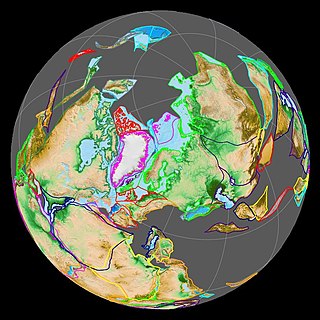
In geology, a supercontinent is the assembly of most or all of Earth's continental blocks or cratons to form a single large landmass. However, some geologists use a different definition, "a grouping of formerly dispersed continents", which leaves room for interpretation and is easier to apply to Precambrian times. To separate supercontinents from other groupings, a limit has been proposed in which a continent must include at least about 75% of the continental crust then in existence in order to qualify as a supercontinent.

Laurasia was the more northern of two large landmasses that formed part of the Pangaea supercontinent from around 335 to 175 million years ago (Mya), the other being Gondwana. It separated from Gondwana 215 to 175 Mya during the breakup of Pangaea, drifting farther north after the split and finally broke apart with the opening of the North Atlantic Ocean c. 56 Mya. The name is a portmanteau of Laurentia and Asia.
An aulacogen is a failed arm of a triple junction. Aulacogens are a part of plate tectonics where oceanic and continental crust is continuously being created, destroyed, and rearranged on the Earth’s surface. Rift zones are places where new crust is formed. An aulacogen is a rift zone that is no longer active.

The African plate, also known as the Nubian plate, is a major tectonic plate that includes much of the continent of Africa and the adjacent oceanic crust to the west and south. It is bounded by the North American plate and South American plate to the west ; the Arabian plate and Somali plate to the east; the Eurasian plate, Aegean Sea plate and Anatolian plate to the north; and the Antarctic plate to the south.

Pangaea Proxima is a possible future supercontinent configuration. Consistent with the supercontinent cycle, Pangaea Proxima could form within the next 250 million years. This potential configuration, hypothesized by Christopher Scotese in November 1982, earned its name from its similarity to the previous Pangaea supercontinent. Scotese later changed Pangaea Ultima to Pangaea Proxima to alleviate confusion about the name Pangaea Ultima which could imply that it would be the last supercontinent. The concept was suggested by extrapolating past cycles of formation and breakup of supercontinents, not on theoretical understanding of the mechanisms of tectonic change, which are too imprecise to project that far into the future. "It's all pretty much fantasy to start with," Scotese has said. "But it's a fun exercise to think about what might happen. And you can only do it if you have a really clear idea of why things happen in the first place."

The supercontinent cycle is the quasi-periodic aggregation and dispersal of Earth's continental crust. There are varying opinions as to whether the amount of continental crust is increasing, decreasing, or staying about the same, but it is agreed that the Earth's crust is constantly being reconfigured. One complete supercontinent cycle is said to take 300 to 500 million years. Continental collision makes fewer and larger continents while rifting makes more and smaller continents.

The Paleo-Tethys or Palaeo-Tethys Ocean was an ocean located along the northern margin of the paleocontinent Gondwana that started to open during the Middle Cambrian, grew throughout the Paleozoic, and finally closed during the Late Triassic; existing for about 400 million years.

The North China Craton is a continental crustal block with one of Earth's most complete and complex records of igneous, sedimentary and metamorphic processes. It is located in northeast China, Inner Mongolia, the Yellow Sea, and North Korea. The term craton designates this as a piece of continent that is stable, buoyant and rigid. Basic properties of the cratonic crust include being thick, relatively cold when compared to other regions, and low density. The North China Craton is an ancient craton, which experienced a long period of stability and fitted the definition of a craton well. However, the North China Craton later experienced destruction of some of its deeper parts (decratonization), which means that this piece of continent is no longer as stable.

The geological history of the Earth follows the major geological events in Earth's past based on the geological time scale, a system of chronological measurement based on the study of the planet's rock layers (stratigraphy). Earth formed about 4.54 billion years ago by accretion from the solar nebula, a disk-shaped mass of dust and gas left over from the formation of the Sun, which also created the rest of the Solar System.

The Longmenshan Fault is a thrust fault which runs along the base of the Longmen Mountains in Sichuan province in southwestern China. The strike of the fault plane is approximately NE. Motion on this fault is responsible for the uplift of the mountains relative to the lowlands of the Sichuan Basin to the east. Representing the eastern boundary of the Qinghai-Tibet Plateau, it is a border formation between the Bayan Kola block in the Plateau and the South China block in the Eurasian plate. The 2008 Wenchuan, 2013 Lushan and 2022 Ya'an earthquakes occurred along this fault.

Gondwana was a large landmass, sometimes referred to as a supercontinent. The remnants of Gondwana make up around two-thirds of today's continental area, including South America, Africa, Antarctica, Australia, Zealandia, Arabia, and the Indian Subcontinent.

Afro-Eurasia is a landmass comprising the continents of Africa, Europe, and Asia. The terms are compound words of the names of its constituent parts. Afro-Eurasia has also been called the "Old World", in contrast to the "New World" referring to the Americas.

Laurentia or the North American Craton is a large continental craton that forms the ancient geological core of North America. Many times in its past, Laurentia has been a separate continent, as it is now in the form of North America, although originally it also included the cratonic areas of Greenland and the Hebridean Terrane in northwest Scotland. During other times in its past, Laurentia has been part of larger continents and supercontinents and consists of many smaller terranes assembled on a network of early Proterozoic orogenic belts. Small microcontinents and oceanic islands collided with and sutured onto the ever-growing Laurentia, and together formed the stable Precambrian craton seen today.

Pangaea or Pangea was a supercontinent that existed during the late Paleozoic and early Mesozoic eras. It assembled from the earlier continental units of Gondwana, Euramerica and Siberia during the Carboniferous approximately 335 million years ago, and began to break apart about 200 million years ago, at the end of the Triassic and beginning of the Jurassic. Pangaea was C-shaped, with the bulk of its mass stretching between Earth's northern and southern polar regions and surrounded by the superocean Panthalassa and the Paleo-Tethys and subsequent Tethys Oceans. Pangaea is the most recent supercontinent to have existed and the first to be reconstructed by geologists.
This is a list of articles related to plate tectonics and tectonic plates.

The island of Taiwan was formed approximately 4 to 5 million years ago at a convergent boundary between the Philippine Sea Plate and the Eurasian Plate. In a boundary running the length of the island and continuing southwards, the Eurasian Plate is sliding under the Philippine Sea Plate. In the northeast of the island, the Philippine Sea Plate slides under the Eurasian Plate. Most of the island comprises a huge fault block tilted to the west.
The South China Sea Basin is one of the largest marginal basins in Asia. South China Sea is located to the east of Vietnam, west of Philippines and the Luzon Strait, and north of Borneo. Tectonically, it is surrounded by the Indochina Block on the west, Philippine Sea Plate on the east, Yangtze Block to the north. A subduction boundary exists between the Philippine Sea Plate and the Asian Plate. The formation of the South China Sea Basin was closely related with the collision between the Indian Plate and Eurasian Plates. The collision thickened the continental crust and changed the elevation of the topography from the Himalayan orogenic zone to the South China Sea, especially around the Tibetan Plateau. The location of the South China Sea makes it a product of several tectonic events. All the plates around the South China Sea Basin underwent clockwise rotation, subduction and experienced an extrusion process from the early Cenozoic to the Late Miocene.

The Huangling Anticline or Complex represents a group of rock units that appear in the middle of the Yangtze Block in South China, distributed across Yixingshan, Zigui, Huangling, and Yichang counties. The group of rock involves nonconformity that sedimentary rocks overlie the metamorphic basement. It is a 73-km long, asymmetrical dome-shaped anticline with axial plane orientating in the north-south direction. It has a steeper west flank and a gentler east flank. Basically, there are three tectonic units from the anticline core to the rim, including Archean to Paleoproterozoic metamorphic basement, Neoproterozoic to Jurassic sedimentary rocks, and Cretaceous fluvial deposit sedimentary cover. The northern part of the core is mainly tonalite-trondhjemite-gneiss (TTG) and Cretaceous sedimentary rock called the Archean Kongling Complex. The middle of the core is mainly the Neoproterozoic granitoid. The southern part of the core is the Neoproterozoic potassium granite. Two basins are situated on the western and eastern flanks of the core, respectively, including the Zigui basin and Dangyang basin. Both basins are synforms while Zigui basin has a larger extent of folding. Yuanan Graben and Jingmen Graben are found within the Dangyang Basin area. The Huangling Anticline is an important area that helps unravel the tectonic history of the South China Craton because it has well-exposed layers of rock units from Archean basement rock to Cretaceous sedimentary rock cover due to the erosion of the anticline.

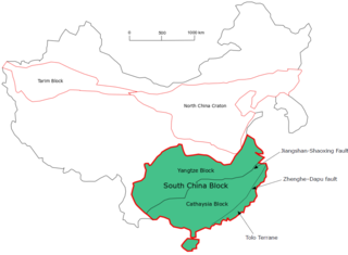
The South China Craton or South China Block is one of the Precambrian continental blocks in China. It is traditionally divided into the Yangtze Block in the NW and the Cathaysia Block in the SE. The Jiangshan–Shaoxing Fault represents the suture boundary between the two sub-blocks. Recent study suggests that the South China Block possibly has one more sub-block which is named the Tolo Terrane. The oldest rocks in the South China Block occur within the Kongling Complex, which yields zircon U–Pb ages of 3.3–2.9 Ga.

The 1626 Lingqiu earthquake had an epicentre in Lingqiu County, Shanxi Province during the Ming dynasty. The estimated surface wave magnitude (Ms ) 7.0 earthquake caused many buildings to collapse. Over 5,200 people were killed.


