Agulhas Basin

Last updated
The Agulhas Basin and some of the bathymetric structures mentioned in the text Agulhas Basin NOAA.jpg
The Agulhas Basin and some of the bathymetric structures mentioned in the text

The Agulhas Basin is an oceanic basin located south of South Africa where the South Atlantic Ocean and south-western Indian Ocean meet. Part of the African Plate, it is bounded by the Agulhas Ridge (part of the Agulhas-Falkland Fracture Zone) to the north and the Southwest Indian Ridge to the south; by the Meteor Rise to the west and the Agulhas Plateau to the east. Numerous bathymetric anomalies hint at the basin's dynamic tectonic history. [1]

Contents

Geology

In a Late Paleocene (59-56 Ma) reconstruction of the opening of the South Atlantic Ocean (i.e. the separation of South America and Africa during the Gondwana break-up) the Meteor Rise lies conjugate to the Islas Orcadas Rise (east of the Falkland Plateau). [1] The separation of the Meteor Rise and the Islas Orcadas Rise marks the beginning of the formation of the Agulhas Basin.

The Agulhas Ridge extends from the northern tip of the Meteor Rise towards the Agulhas Bank south of South Africa. The ridge, however, ends abruptly in a small plateau at 40°S15°E / 40°S 15°E / -40; 15 where it intersects a northeastward-trending spreading centre (the Agulhas Rift) that was abandoned during the Early Paleocene (61 Ma). [1] The presence of a short-lived tectonic plate between these structures was first proposed by LaBrecque & Hayes 1979. They named it the Malvinas Plate and proposed that it was active from 90 Ma until the spreading ceased in the Agulhas Basin at 65 Ma. The plate is located at a proto-Bouvet Triple Junction. [2]

Marks & Stock 2001 found that Late Cretaceous (100-66 Ma) fracture zones generated on the Agulhas Rift do not align with those north of the Agulhas Fracture Zone and cannot therefore have been formed by the spreading of South America and Africa. Furthermore, magnetic anomalies on the Malvinas Plate do not align with their conjugates on the African Plate if the spreading rates and directions of South America and Africa are used as a guide. They also noted that the Agulhas Fracture Zone do not lay perpendicular to traces of the South America-Africa spreading north of it and cannot, therefore, have been generate by this spreading. [3]

The Agulhas Rift is the abandoned Malvinas-Africa ridge crest. 97 Ma the plate boundary in the Agulhas Basin was reorganised when the Mid-Atlantic Ridge made an eastward jump. This brought the boundary towards the Agulhas Plateau where excessive volcanism was building a large igneous province. The inception of the Malvinas Plate accompanied this shortening of the Agulas Fracture Zone. 61 Ma, the Malvinas Plate was finally incorporated into the African Plate when the Malvinas-Africa ridge was abandoned as the result of a westward ridge jump along the Agulhas-Falkland Fracture Zone. [4] This second ridge jump reduced one of the most spectacular fracture zones in Earth's history 1,200 km (750 mi) in length  to 180 km (110 mi). [5]

Oceanography

The Agulhas Current flows south along the African east coast. When it reaches the southern tip of Africa, it retroflects back into the Indian Ocean. At this retroflection it leaks warm core eddies known as Agulhas rings into the South Atlantic. This mesoscale anti-cyclonic rings feed the Atlantic meridional overturning circulation (AMOC) and are therefore believed to affect the global climate, although the connection between the leakage, AMOC, and climate change is still poorly understood. [6] In the Agulhas basin, half of these rings are subdivided one or several times. A majority of the subdivided rings split at or near the bathymetric obstacles on the western side of the Agulhas Basin but almost a quarter of them also merge there either because of the obstacles or because of intense interaction with other rings. [7]

Antarctic Bottom Water (AABW) originated in the Oligocene with the opening of the Drake Passage and the Tasmanian Seaway and resulted in the thermal insulation of Antarctica. AABW mixes with other masses in the Antarctic Circumpolar Current (ACC) to form the Circumpolar Deep Water (CDW). In the Agulhas Basin CDW flows northward and is deflect mostly westward by the Agulhas Ridge. A branch of CDW, however, enters the Cape Basin west of the ridge from where it flows west along the northern side of the ridge before being deflected north-east (along the Walvis Ridge) at the eastern end of the ridge. This long detour in the Cape Basin and mixing with North Atlantic Deep Water (NADW) results in warmer water than other CDW masses. Antarctic Intermediate Water (AAIW) flows above the CDW in the Agulhas Basin in an anti-cyclonic path (in contrast to the cyclonic path followed by CDW.) [8]

Related Research Articles

<span class="mw-page-title-main">Atlantic Ocean</span> Ocean between Europe, Africa and the Americas

The Atlantic Ocean is the second-largest of the world's five oceans, with an area of about 106,460,000 km2 (41,100,000 sq mi). It covers approximately 20% of Earth's surface and about 29% of its water surface area. It is known to separate the "Old World" of Africa, Europe, and Asia from the "New World" of the Americas in the European perception of the World.

<span class="mw-page-title-main">Mid-Atlantic Ridge</span> Atlantic Ocean tectonic plate boundary

The Mid-Atlantic Ridge is a mid-ocean ridge located along the floor of the Atlantic Ocean, and part of the longest mountain range in the world. In the North Atlantic, the ridge separates the North American from the Eurasian Plate and the African Plate, north and south of the Azores Triple Junction. In the South Atlantic, it separates the African and South American plates. The ridge extends from a junction with the Gakkel Ridge northeast of Greenland southward to the Bouvet Triple Junction in the South Atlantic. Although the Mid-Atlantic Ridge is mostly an underwater feature, portions of it have enough elevation to extend above sea level, for example in Iceland. The ridge has an average spreading rate of about 2.5 centimetres (1 in) per year.

<span class="mw-page-title-main">Scotia Plate</span> Minor oceanic tectonic plate between the South American and Antarctic Plates

The Scotia Plate is a tectonic plate on the edge of the South Atlantic and Southern oceans. Thought to have formed during the early Eocene with the opening of the Drake Passage that separates South America from Antarctica, it is a minor plate whose movement is largely controlled by the two major plates that surround it: the South American Plate and the Antarctic Plate. The Scotia Plate takes its name from the steam yacht Scotia of the Scottish National Antarctic Expedition (1902–04), the expedition that made the first bathymetric study of the region.

<span class="mw-page-title-main">Mid-ocean ridge</span> Basaltic underwater mountain system formed by plate tectonic spreading

A mid-ocean ridge (MOR) is a seafloor mountain system formed by plate tectonics. It typically has a depth of about 2,600 meters (8,500 ft) and rises about 2,000 meters (6,600 ft) above the deepest portion of an ocean basin. This feature is where seafloor spreading takes place along a divergent plate boundary. The rate of seafloor spreading determines the morphology of the crest of the mid-ocean ridge and its width in an ocean basin.

<span class="mw-page-title-main">Agulhas Bank</span> Broad southernmost part of the African continental shelf

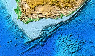
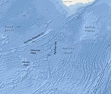
The Agulhas Bank is a broad, shallow part of the southern African continental shelf which extends up to 250 km (160 mi) south of Cape Agulhas before falling steeply to the abyssal plain.

<span class="mw-page-title-main">Antarctic bottom water</span> Cold, dense, water mass originating in the Southern Ocean surrounding Antarctica

The Antarctic bottom water (AABW) is a type of water mass in the Southern Ocean surrounding Antarctica with temperatures ranging from −0.8 to 2 °C (35 °F) and salinities from 34.6 to 34.7 psu. As the densest water mass of the oceans, AABW is found to occupy the depth range below 4000 m of all ocean basins that have a connection to the Southern Ocean at that level.

<span class="mw-page-title-main">Oceanic plateau</span> Relatively flat submarine region that rises well above the level of the ambient seabed

An oceanic or submarine plateau is a large, relatively flat elevation that is higher than the surrounding relief with one or more relatively steep sides.

<span class="mw-page-title-main">Southwest Indian Ridge</span> A mid-ocean ridge on the bed of the south-west Indian Ocean and south-east Atlantic Ocean

The Southwest Indian Ridge (SWIR) is a mid-ocean ridge located along the floors of the south-west Indian Ocean and south-east Atlantic Ocean. A divergent tectonic plate boundary separating the Somali Plate to the north from the Antarctic Plate to the south, the SWIR is characterised by ultra-slow spreading rates (only exceeding those of the Gakkel Ridge in the Arctic) combined with a fast lengthening of its axis between the two flanking triple junctions, Rodrigues (20°30′S70°00′E) in the Indian Ocean and Bouvet (54°17′S1°5′W) in the Atlantic Ocean.

<span class="mw-page-title-main">South American–Antarctic Ridge</span> Mid-ocean ridge in the South Atlantic between the South American Plate and the Antarctic Plate

The South American–Antarctic Ridge or simply American-Antarctic Ridge is the tectonic spreading center between the South American Plate and the Antarctic Plate. It runs along the sea-floor from the Bouvet Triple Junction in the South Atlantic Ocean south-westward to a major transform fault boundary east of the South Sandwich Islands. Near the Bouvet Triple Junction the spreading half rate is 9 mm/a (0.35 in/year), which is slow, and the SAAR has the rough topography characteristic of slow-spreading ridges.

<span class="mw-page-title-main">Walvis Ridge</span> Aseismic ocean ridge in the southern Atlantic Ocean

The Walvis Ridge is an aseismic ocean ridge in the southern Atlantic Ocean. More than 3,000 km (1,900 mi) in length, it extends from the Mid-Atlantic Ridge, near Tristan da Cunha and the Gough Islands, to the African coast. The Walvis Ridge is one of few examples of a hotspot seamount chain that links a flood basalt province to an active hotspot. It is also considered one of the most important hotspot tracks because the Tristan Hotspot is one of few primary or deep mantle hotspots.

<span class="mw-page-title-main">Shona hotspot</span>

The Shona or Meteor hotspot is a volcanic hotspot located in the southern Atlantic Ocean. Its zig-zag-shaped hotspot track, a chain of seamounts and ridges, stretches from its current location at or near the southern end of the Mid-Atlantic Ridge to South Africa.

Maud Rise is an oceanic plateau, which rises, at its shallowest, to depths of about a 1,000 meters. It is located in the Weddell Sea in the Southern Ocean. Its name was approved by the Advisory Committee for Undersea Features in June 1987.

<span class="mw-page-title-main">Rio Grande Rise</span> Aseismic ocean ridge in the southern Atlantic Ocean off the coast of Brazil

The Rio Grande Rise, also called the Rio Grande Elevation or Bromley Plateau, is an aseismic ocean ridge in the southern Atlantic Ocean off the coast of Brazil. Together with the Walvis Ridge off Africa, the Rio Grande Rise forms a V-shaped structure of mirrored hotspot tracks or seamount chains across the northern South Atlantic. In 2013, Brazilian scientists announced that they found granite boulders on the Rio Grande Rise and speculated that it could be the remains of a submerged continent, which they called the "Brazilian Atlantis". Other researchers, however, noted that such boulders can end-up on the ocean floor by less speculative means.

<span class="mw-page-title-main">Geology of the Pacific Ocean</span> Overview about the geology of the Pacific Ocean

The Pacific Ocean evolved in the Mesozoic from the Panthalassic Ocean, which had formed when Rodinia rifted apart around 750 Ma. The first ocean floor which is part of the current Pacific Plate began 160 Ma to the west of the central Pacific and subsequently developed into the largest oceanic plate on Earth.

<span class="mw-page-title-main">Agulhas Plateau</span>

The Agulhas Plateau is an oceanic plateau located in the south-western Indian Ocean about 500 km (310 mi) south of South Africa. It is a remainder of a large igneous province (LIP), the Southeast African LIP, that formed 140 to 95 million years ago (Ma) at or near the triple junction where Gondwana broke-up into Antarctica, South America, and Africa. The plateau formed 100 to 94 Ma together with Northeast Georgia Rise and Maud Rise when the region passed over the Bouvet hotspot.

<span class="mw-page-title-main">Agulhas Passage</span> Abyssal channel south of South Africa between the Agulhas Bank and Agulhas Plateau

The Agulhas Passage is an abyssal channel located south of South Africa between the Agulhas Bank and Agulhas Plateau. About 50 km (31 mi) wide, it connects the Natal Valley and Transkei Basin in the north to the Agulhas Basin in the south and is the only near-shore connection between the south-western Indian Ocean and South Atlantic Ocean.

<span class="mw-page-title-main">Northeast Georgia Rise</span>

The Northeast Georgia Rise is an oceanic plateau located in the South Atlantic Ocean northeast of South Georgia Island and west of the Falkland Plateau.

Discovery Seamounts are a chain of seamounts in the Southern Atlantic Ocean, which include the Discovery Seamount. The seamounts lie 850 kilometres (530 mi) east of Gough Island and once rose above sea level. Various volcanic rocks as well as glacial dropstones and sediments have been dredged from the seamounts.

References

Notes

  1. 1 2 3 Raymond & LaBrecque 1988 , Introduction, p. 27
  2. Raymond & LaBrecque 1988 , Agulhas Fracture Zone Ridge, pp. 28-29
  3. Marks & Stock 2001 , Abstract; Marks 2001
  4. Pérez-Díaz & Eagles 2014 , 4.5 The Short Life of a Small Plate in the South Atlantic (80 Ma to Present), p. 19; Figs. 13-14, pp. 16-17
  5. Bird 2001 , Agulhas-Falkland Fracture Zone, p. 152
  6. Beal et al. 2011 , p. 1
  7. Dencausse, Arhan & Speich 2010 , "Initial rings" and "sub-rings", pp. 6-7
  8. Schut, Uenzelmann-Neben & Gersonde 2002 , Oceanography, p. 187

Sources

  • Beal, L. M.; De Ruijter, W. P. M.; Biastoch, A.; Zahn, R.; SCOR/WCRP/IAPSO Working Group 136 (2011). "On the role of the Agulhas system in ocean circulation and climate". Nature. 472 (7344): 429–436. doi:10.1038/nature09983. PMID   21525925. S2CID   4424886.
  • Bird, D. (2001). "Shear margins: Continent-ocean transform and fracture zone boundaries" (PDF). The Leading Edge. 20 (2): 150–159. doi:10.1190/1.1438894 . Retrieved 4 January 2015.
  • Dencausse, G.; Arhan, M.; Speich, S. (2010). "Routes of Agulhas Rings in the southeastern Cape Basin" (PDF). Deep-Sea Research Part I: Oceanographic Research Papers. 57 (11): 1406–1421. doi:10.1016/j.dsr.2010.07.008 . Retrieved 10 July 2015.
  • LaBrecque, J. L.; Hayes, D. E. (1979). "Seafloor spreading history of the Agulhas Basin". Earth and Planetary Science Letters. 45 (2): 411–428. Bibcode:1979E&PSL..45..411L. doi:10.1016/0012-821X(79)90140-7.
  • Marks (2001). "Malvinas plate controversy resolved using altimetry" (PDF). Earth System Monitor. 11 (4): 1–2, 4. Retrieved 10 July 2015.
  • Marks, K. M.; Stock, J. M. (2001). "Evolution of the Malvinas Plate South of Africa". Marine Geophysical Researches. 22 (4): 289–302. doi:10.1023/A:1014638325616. S2CID   130601372.
  • Pérez-Díaz, L.; Eagles, G. (2014). "Constraining South Atlantic growth with seafloor spreading data" (PDF). Tectonics. 33 (9): 1848–1873. Bibcode:2014Tecto..33.1848P. doi:10.1002/2014TC003644 . Retrieved 10 July 2015.
  • Raymond, C. A.; LaBrecque, J. L. (1988). "Geophysical signatures of the Agulhas Fracture Zone Ridge and Meteor Rise, Indo-Atlantic basin" (PDF). Proceedings of the Ocean Drilling Program, Initial Reports. 114: 27–33. Retrieved 10 July 2015.
  • Schut, E. W.; Uenzelmann-Neben, G.; Gersonde, R. (2002). "Seismic evidence for bottom current activity at the Agulhas Ridge" (PDF). Global and Planetary Change. 34 (3–4): 185–198. doi:10.1016/s0921-8181(02)00114-5 . Retrieved 10 July 2015.

Coordinates: 45°S20°E / 45°S 20°E / -45; 20