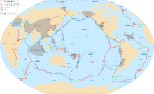
The Tonga Trench is an oceanic trench located in the southwestern Pacific Ocean. It is the deepest trench in the Southern hemisphere and the second deepest on Earth after the Mariana Trench. The fastest plate-tectonic velocity on Earth is occurring at this location, as the Pacific Plate is being subducted westward in the trench.

The Phoenix Plate was a tectonic plate that existed during the early Paleozoic through late Cenozoic time. It formed a triple junction with the Izanagi and Farallon plates in the Panthalassa Ocean as early as 410 million years ago, during which time the Phoenix Plate was subducting under eastern Gondwana.

The Kerguelen hotspot is a volcanic hotspot at the Kerguelen Plateau in the Southern Indian Ocean. The Kerguelen hotspot has produced basaltic lava for about 130 million years and has also produced the Kerguelen Islands, Naturaliste Plateau, Heard Island, the McDonald Islands, and Rajmahal Traps. One of the associated features, the Ninety East Ridge, is distinguished by its over 5,000 km (3,100 mi) length, being the longest linear tectonic feature on Earth. The total volume of magma erupted in 130 million years with associated features has been estimated to be about 25,000,000 km3 (6,000,000 cu mi). However, as well as large igneous provinces and seamounts the hotspot has interacted with other seafloor spreading features, so this volume figure has some uncertainty.

The Southwest Indian Ridge (SWIR) is a mid-ocean ridge located along the floors of the south-west Indian Ocean and south-east Atlantic Ocean. A divergent tectonic plate boundary separating the Somali Plate to the north from the Antarctic Plate to the south, the SWIR is characterised by ultra-slow spreading rates (only exceeding those of the Gakkel Ridge in the Arctic) combined with a fast lengthening of its axis between the two flanking triple junctions, Rodrigues (20°30′S70°00′E) in the Indian Ocean and Bouvet (54°17′S1°5′W) in the Atlantic Ocean.

The Macquarie Triple Junction is a geologically active tectonic boundary located at 61°30′S161°0′E at which the historic Indo-Australian Plate, Pacific Plate, and Antarctic Plate collide and interact. The term Triple Junction is given to particular tectonic boundaries at which three separate tectonic plates meet at a specific, singular location. The Macquarie Triple Junction is located on the seafloor of the southern region of the Pacific Ocean, just south of New Zealand. This tectonic boundary was named in respect to the nearby Macquarie Island, which is located southeast of New Zealand.

The Louisville Ridge, often now referred to as the Louisville Seamount Chain, is an underwater chain of over 70 seamounts located in the Southwest portion of the Pacific Ocean. As one of the longest seamount chains on Earth it stretches some 4,300 km (2,700 mi) from the Pacific-Antarctic Ridge northwest to the Tonga-Kermadec Trench, where it subducts under the Indo-Australian Plate as part of the Pacific Plate. The chains formation is best explained by movement of the Pacific Plate over the Louisville hotspot although others had suggested by leakage of magma from the shallow mantle up through the Eltanin fracture zone, which it follows closely for some of its course.

The Louisville hotspot is a volcanic hotspot responsible for the volcanic activity that has formed the Louisville Ridge in the southern Pacific Ocean.

The Marquesas hotspot is a volcanic hotspot in the southern Pacific Ocean. It is responsible for the creation of the Marquesas Islands – a group of eight main islands and several smaller ones – and a few seamounts. The islands and seamounts formed between 5.5 and 0.4 million years ago and constitute the northernmost volcanic chain in French Polynesia.

The Shona or Meteor hotspot is a volcanic hotspot located in the southern Atlantic Ocean. Its zig-zag-shaped hotspot track, a chain of seamounts and ridges, stretches from its current location at or near the southern end of the Mid-Atlantic Ridge to South Africa.

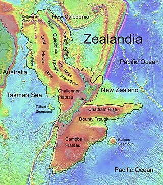
Bollons Seamount or Bollons Tablemount is a seamount just east of the international date line, a few hundred miles off the coast of New Zealand. It represents a continental fragment that separated from Zealandia as a result of rifting. The seamount was involved in a 2002 survey and collection project defined to find the edge of New Zealand's continental shelf. The Bollons Seamount has been shown to be a site of extensive Cretaceous-era rifting in the area towards the southern Chatham Rise between 83.7 and 78.5 MYA.

The Eltanin Fault System is a series of six or seven dextral transform faults that offset the Pacific-Antarctic Ridge, a spreading zone between the Pacific Plate and the Antarctic Plate. This is extending by up to 7.93 cm/year (3.12 in/year). It was named after USNS Eltanin. The affected zone of the Pacific-Antarctic Ridge is about 800 km (500 mi) long, between 56° S, 145° W and 54.5° S, 118.5° W, southwest of Easter Island, and about as far as one can get from land on planet Earth. However, the total offset is about 1600 km. The two major faults in the Eltanin Fracture Zone are the Heezen transform fault and the Tharp transform fault, usually known as fracture zones as they extend inactively from the Pacific-Antarctic Ridge. A third named after Hollister, which is the shortest to the south, also exists and its active transform region has been linked to the other transform regions of the Eltanin Fault System. They are about 1,000 km (620 mi) long and have been in the last 50 years the location of many earthquakes of up to 6.4. One segment of the Heezen transform has ruptured with an average repeat interval of 4 years. Others related faults include the Vacquier Transform Fault, the Menard Transform Fault, and the Udintsev Fault.

The Rio Grande Rise, also called the Rio Grande Elevation or Bromley Plateau, is an aseismic ocean ridge in the southern Atlantic Ocean off the coast of Brazil. Together with the Walvis Ridge off Africa, the Rio Grande Rise forms a V-shaped structure of mirrored hotspot tracks or seamount chains across the northern South Atlantic. In 2013, Brazilian scientists announced that they found granite boulders on the Rio Grande Rise and speculated that it could be the remains of a submerged continent, which they called the "Brazilian Atlantis". Other researchers, however, noted that such boulders can end-up on the ocean floor by less speculative means.

The Pacific Ocean evolved in the Mesozoic from the Panthalassic Ocean, which had formed when Rodinia rifted apart around 750 Ma. The first ocean floor which is part of the current Pacific Plate began 160 Ma to the west of the central Pacific and subsequently developed into the largest oceanic plate on Earth.
Foundation Seamounts are a series of seamounts in the southern Pacific Ocean. Discovered in 1992, these seamounts form a 1,350 kilometres (840 mi) long chain which starts from the Pacific-Antarctic Ridge. Some of these seamounts may have once emerged from the ocean.

Musicians Seamounts are a chain of seamounts in the Pacific Ocean, north of the Hawaiian Ridge. There are about 65 seamounts, some of which are named after musicians. These seamounts exist in two chains, one of which has been attributed to a probably now-extinct hotspot called the Euterpe hotspot. Others may have formed in response to plate tectonics associated with the boundary between the Pacific Plate and the former Farallon Plate.
Hollister Ridge is a group of seamounts in the Pacific Ocean. They lie west from the Pacific-Antarctic Ridge and form three ridges that form a line; one of the ridges rises to a depth of 100 metres (330 ft) and in the past formed an island. The seamounts are composed out of basaltic and other rocks and their ages range from about 2.5 million years ago to latest Pleistocene; an acoustic swarm recorded in the southern Pacific Ocean in 1991-1992 is considered to be the manifestation of a historical eruption of the Hollister Ridge.
Crough Seamount is a seamount in the Pacific Ocean, within the exclusive economic zone of Pitcairn. It rises to a depth of 650 metres (2,130 ft) and is paired with a taller but overall smaller seamount to the east. This seamount has a flat top and probably formed an island in the past. It is about 7-8 million years old, although a large earthquake recorded at its position in 1955 may indicate a recent eruption.
Erimo Seamount is a seamount off Hokkaido, Japan. Located close to the intersection between the Kuril-Kamchatka and Japan Trenches, it is in the process of being subducted. The Cretaceous seamount formed 100-120 million years ago and is covered by a limestone cap. Tiltmeters have been installed on its top.

The Wishbone scarp is a Pacific Ocean floor feature in the oceanic crust, that if it were on land would be similar to a mountain range fault system over 1,000 km (620 mi) long. It commences in the north near the Osbourn Trough although it is likely to be related tectonically to the Manihiki scarp somewhat to its north. To the south it splits into west and east scarps that have been intercepted by the Louisville hotspot with the West Wishbone scarp continuing until it intercepts the Chatham Rise. There is now evidence that the entire scarp has a fracture zone origin resolving previous uncertainty on this issue.


