Related Research Articles

The Atlantic Ocean is the second-largest of the world's oceans, with an area of about 106,460,000 km2 (41,100,000 sq mi). It covers approximately 20 percent of Earth's surface and about 29 percent of its water surface area. It is known to separate the "Old World" from the "New World" in the European perception of the World.

An ocean current is a continuous, directed movement of sea water generated by a number of forces acting upon the water, including wind, the Coriolis effect, breaking waves, cabbeling, and temperature and salinity differences. Depth contours, shoreline configurations, and interactions with other currents influence a current's direction and strength. Ocean currents are primarily horizontal water movements.

The Agulhas Current is the western boundary current of the southwest Indian Ocean. It flows south along the east coast of Africa from 27°S to 40°S. It is narrow, swift and strong. It is suggested that it is the largest western boundary current in the world ocean, with an estimated net transport of 70 sverdrups, as western boundary currents at comparable latitudes transport less — Brazil Current, Gulf Stream, Kuroshio.

In oceanography, a gyre is any large system of circulating ocean currents, particularly those involved with large wind movements. Gyres are caused by the Coriolis effect; planetary vorticity, horizontal friction and vertical friction determine the circulatory patterns from the wind stress curl (torque).
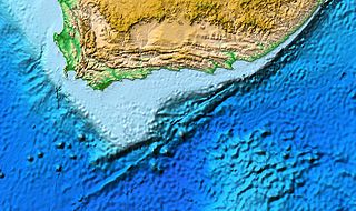
The Agulhas Bank is a broad, shallow part of the southern African continental shelf which extends up to 250 km (160 mi) south of Cape Agulhas before falling steeply to the abyssal plain.
The North Equatorial Current (NEC) is a westward wind-driven current mostly located near the equator, but the location varies from different oceans. The NEC in the Pacific and the Atlantic is about 5°-20°N, while the NEC in the Indian Ocean is very close to the equator. It ranges from the sea surface down to 400 m in the western Pacific.
The Madagascar current is an oceanic current in the west Indian Ocean.
The Tasman Outflow is a water pathway connecting water from the Pacific Ocean and the Indian Ocean. The existence of the outflow was published by scientists of the Australian CSIRO's Division of Marine and Atmospheric Research team in August 2007, interpreting salinity and temperature data captured from 1950 to 2002. The Tasman Outflow is seen as the missing link in the supergyre of the Southern Hemisphere and an important part of the thermohaline circulation.

Boundary currents are ocean currents with dynamics determined by the presence of a coastline, and fall into two distinct categories: western boundary currents and eastern boundary currents.

The Beaufort Gyre is one of the two major ocean currents in the Arctic Ocean, it is roughly located north of the Alaskan and Canadian coast. In the past, Arctic sea-ice would circulate in the Beaufort gyre up to several years, leading to the formation of very thick multi-year sea-ice. Due to warming temperatures in the Arctic, the gyre has lost an extensive amount of ice, practically turning what used to be a nursery for sea-ice to mature and grow into the thickest and oldest ice of the Arctic Ocean into a "graveyard" for older ice.

Nils Daniel Bang was a South African oceanographic scientist who was a pioneer in the study of the fine structure of coastal upwelling systems. In March 1969, Bang initiated, planned and executed South Africa's first truly multi-ship oceanographical research operation, the Agulhas Current Project, along the current's length. Although the research was conducted on a limited budget and with rudimentary equipment, Bang's studies using thousands of closely spaced bathythermograph readings were later corroborated by satellite imagery and airborne radiation thermometry.
The Rapid Climate Change-Meridional Overturning Circulation and Heatflux Array program is a collaborative research project between the National Oceanography Centre, the University of Miami’s Rosenstiel School of Marine and Atmospheric Science (RSMAS), and NOAA’s Atlantic Oceanographic and Meteorological Laboratory (AOML) that measure the meridional overturning circulation (MOC) and ocean heat transport in the North Atlantic Ocean. This array was deployed in March 2004 to continuously monitor the MOC and ocean heat transport that are primarily associated with the Thermohaline Circulation across the basin at 26°N. The RAPID-MOCHA array is planned to be continued through 2014 to provide a decade or longer continuous time series.
The Good Hope Jet is the northward-running shelf edge frontal jet of the Southern Benguela Current off the Cape Peninsula of South Africa's west coast. The jet, an intrusion of water from the Agulhas Current, was first described by South African oceanographers, Nils Bang and W.R.H. (Bill) Andrews in 1974. This warm water jet forms a sharp front as it comes into contact with the colder upwelled water over the shelf and plays a key role in carrying fish eggs and larvae from their food-poor Agulhas Bank spawning grounds to inshore nurseries.
Johann Reinder Erlers Lutjeharms, was a leading South African marine scientist and an authority in the oceanography of the Agulhas Current, who authored a definitive work on the subject, The Agulhas Current. His main field of investigation was the large-scale circulation patterns of the oceans adjacent to southern Africa and their influence on weather and climate, and he participated in 17 research cruises and was responsible for a further 48 projects undertaken on such cruises.

The Global Drifter Program (GDP), was conceived by Prof. Peter Niiler, with the objective of collecting measurements of surface ocean currents, sea surface temperature and sea-level atmospheric pressure using drifters. It is the principal component of the Global Surface Drifting Buoy Array, a branch of NOAA's Global Ocean Observations and a scientific project of the Data Buoy Cooperation Panel (DBCP). The project originated in February 1979 as part of the TOGA/Equatorial Pacific Ocean Circulation Experiment (EPOCS) and the first large-scale deployment of drifters was in 1988 with the goal of mapping the tropical Pacific Ocean's surface circulation. The current goal of the project is to use 1250 satellite-tracked surface drifting buoys to make accurate and globally dense in-situ observations of mixed layer currents, sea surface temperature, atmospheric pressure, winds and salinity, and to create a system to process the data. Horizontal transports in the oceanic mixed layer measured by the GDP are relevant to biological and chemical processes as well as physical ones.

The Agulhas Return Current (ARC) is an ocean current in the South Indian Ocean. The ARC contributes to the water exchange between oceans by forming a link between the South Atlantic Current and the South Indian Ocean Current. It can reach velocities of up to 4 knots and is therefore popular among participants in trans-oceanic sailing races.

The Agulhas Basin is an oceanic basin located south of South Africa where the South Atlantic Ocean and south-western Indian Ocean meet. Part of the African Plate, it is bounded by the Agulhas Ridge to the north and the Southwest Indian Ridge to the south; by the Meteor Rise to the west and the Agulhas Plateau to the east. Numerous bathymetric anomalies hint at the basin's dynamic tectonic history.
A Wind generated current is a flow in a body of water that is generated by wind friction on its surface. Wind can generate surface currents on water bodies of any size. The depth and strength of the current depend on the wind strength and duration, and on friction and viscosity losses, but are limited to about 400 m depth by the mechanism, and to lesser depths where the water is shallower. The direction of flow is influenced by the Coriolis effect, and is offset to the right of the wind direction in the Northern Hemisphere, and to the left in the Southern Hemisphere. A wind current can induce secondary water flow in the form of upwelling and downwelling, geostrophic flow, and western boundary currents.
Low-latitude western boundary currents (LLWBC) are western boundary currents located between the subtropical gyres, within 20° of the equator. They are important for closing the tropical circulation driven by the equatorial zonal flow, and facilitate inter-ocean transport between the subtropical gyres. They occur in regions of negative (positive) wind stress curl in the southern (northern) hemisphere, and originate at the western bifurcation point of the South or North Equatorial Current. They are typically equatorward (cyclonic) as opposed to sub-tropical western boundary currents, which tend to be poleward (anticyclonic). Some well-known examples include the Mindanao Current (MC) and the East African Coastal Current (EACC).
Ring shedding is a phenomenon in ocean currents where circle or ring-shaped eddies separate from the current. The rings are independent water current systems that can persist for several months and occur in most ocean basins. The separated rings can have both warm or cold cores and play a role in the thermohaline circulation, interocean mixing, and nutrient supply for algae and bacteria. The physical processes behind ring shedding are not fully understood yet and are thus an active subject of research.
References
- ↑ Lutjeharms, J. R. E. (2006). "Three decades of research on the greater Agulhas Current" (PDF). Ocean Sci. Discuss. 3: 939–995. OCLC 800498605.
- ↑ Bang, N. D. (1970). "Dynamic interpretations of a detailed surface temperature chart of the Agulhas Current retroflection and fragmentation area". South African Geographical Journal. 52: 67–76. doi:10.1080/03736245.1970.10559466.
- 1 2 Sciendaba, Vol XII No 48, 15 December 1977
- ↑ Lutjeharms, J. R. E (1981). "Features of the southern Agulhas Current circulation from satellite remote sensing". South African Journal of Science. 77: 231–236.
- ↑
 This article incorporates public domain material from websites or documents ofthe National Oceanic and Atmospheric Administration .
 - "Long Term Time Series of Surface Currents, North Brazil Current" (Online (website)). NOAA-AOML. June 8, 2007. Retrieved 2011-05-28.
- ↑ This article incorporates public domain material from websites or documents ofthe National Oceanic and Atmospheric Administration .
- "North Brazil Current" (Online (website)). NOAA-AOML. Retrieved 2011-05-28.
- ↑ This paragraph is copied from the section entitled Retroflection in the Wikipedia article entitled Agulhas Current. This for attribution only and it is not considered a reliable source.